 Stefanie Hautmann* explores the subsurface structure of Montserrat (West Indies) using Bouguer gravity data
Falling apples, dropped i-phones and smashed wine glasses come to most people’s minds if you mention it: gravity as nuisance. However, gravity is more than an annoyance. It is the measurable force of attraction of one mass to another. In order to measure gravity, all you need is – a gravity meter.
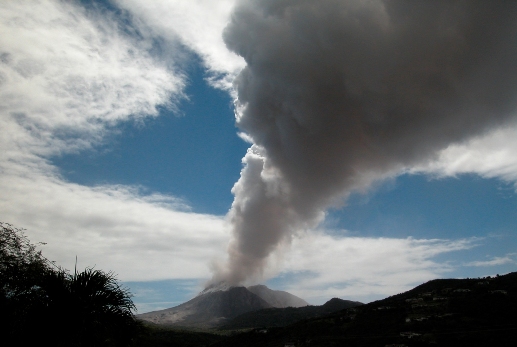
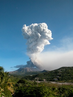
Picture, by Eric Tomme: Volcanic gas plume, Montserrat.
Gravity meters are highly sensitive instruments that comprise an evacuated box with a mass inside, attached to a spring. The attraction exerted on the mass can be measured via the mechanical extension and shortening of this spring. With a portable gravity meter one may measure very tiny differences in gravity resulting from different densities of subsurface rocks. As the density of rocks in the subsurface increases, so does the gravitational attraction measured at surface. Thus, high resolution gravity data can help us to detect spatial inhomogeneities in the density distribution of the Earth's shallow subsurface. Images of subsurface density distribution (so called ‘Bouguer anomaly maps’) and identification of structural discontinuities in the ground are of particular interest in active volcanic regions, because they bear implications for edifice stability, fluid migration in the ground, and the subsurface transmission of volcanically induced stresses.
SOUFRIÈRE
Soufrière Hills Volcano (SHV) is an andesitic dome-building volcano that dominates the small Caribbean Island Montserrat (West Indies). For almost two decades the volcano has been in a heightened state of activity, with periodically repeating episodes of lava-dome extrusion accompanied by discrete volcanic events, such as Vulcanian explosions, gas emission, ash venting, and dome collapses.
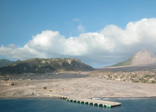 Picture:Remains of the island's capital Plymouth, which was inhabited by about 4,000 people before the volcanic eruption started. Since the onset of volcanic activity in 1995, the city has repeatedly been hit by pyroclastic flows and covered by tephra and ash. In 1997 it was finally abandoned. The active Soufrière Hills Volcano is shown on the right of the picture. (picture Eric Tomme)
Periods of increased activity usually last for several years and are interrupted by episodes of very low volcanic activity and cessation of lava extrusion at the vent1. The continuing eruption has devastated an area of more than 50km2 around the volcano, including the island's capital Plymouth and the former airport. The south of the island was abandoned in 1997 and was declared an 'exclusion zone' with restricted access. Most people left the island, while the ones who stayed had to move to northern Montserrat, which is considered as safe. Today, entry to the exclusion zone is forbidden to the public because of the threat of volcanic activity.
The persistently active SHV has been monitored since the eruption began, and the recorded data have provided unprecedented and unique insights into the eruption dynamics of an island-arc volcano. SHV is currently one of the most extensively studied actively erupting stratovolcanoes2, though a local Bouguer anomaly map of the volcano and the island of Montserrat has been missing to date. I therefore conducted a static gravity survey on Montserrat in order to map the density distribution in the subsurface and to identify structural discontinuities. This was the first step in a project that will assess the island's gravity field, including time-dependent variations relating to changes in volcanic activity. As variations in a system cannot, however, be adequately assessed without knowledge of its steady state, the construction of a conceptual model of the island’s gravity field (the Bouguer gravity map) is essential for future investigation of dynamic changes.
FIELD WORK
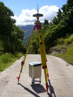 Picture: Setup at a gravity benchmark in northern Montserrat (Silver Hills). Gravity measurements were taken using a Scintrex CG-5 Autograv, while site positions and elevations were obtained via a TOPCON Hiperpro dual frequency GNSS receiver/antenna.
Setup at a gravity benchmark in northern Montserrat (Silver Hills). Gravity measurements were taken using a Scintrex CG-5 Autograv, while site positions and elevations were obtained via a TOPCON Hiperpro dual frequency GNSS receiver/antenna.
A total of 160 new gravity readings were taken across the entire island, with site positions and elevations obtained via GNSS (Global Navigation Satellite System) receiver/antenna. As data collection in the vicinity of an actively erupting volcano obviously involves some safety restrictions, some sampling sites could only be visited via helicopter during routine monitoring flights by the Montserrat Volcano Observatory. The island, however, offers challenges for a gravity survey over and above mere volcanic activity.
The inner Centre Hills are overgrown by a thick rainforest with soft soils that do not provide sufficient ground stability for precise gravity measurements; while the dense vegetation itself hampers satellite-based site positioning. Moreover, populated parts of the island can be challenging for a survey, as road conditions (not only in the exclusion zone!) render the smooth transportation of highly sensitive instruments like gravity meters difficult.
Accounting for such limitations in accessibility, a final Bouguer gravity network was established providing dense coverage (200m between adjacent sites) of the accessible regions of the older volcanic complexes. Network coverage around the active SHV is sparser, with about 1km between adjacent sites.
DATA & MODELLING
Standard techniques were applied to correct the data for the effect of benchmark elevation (free-air effect) and latitude3. Correction for topographic effects was made using an automated algorithm based on a digital elevation model and bathymetric data. The resulting gravity data allowed the construction of a Bouguer gravity map of Montserrat.
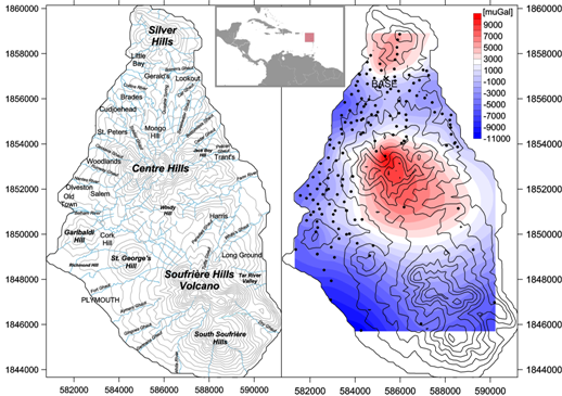 Picture: Topographic (left) and Bouguer (right) map of Montserrat. Gravity sampling sites are given by black points in the Bouguer map. Positive density anomalies are shown in red, while negative density anomalies are shown in blue. Gravity values are relative to a base site, which is located near Gerald's in the north of Montserrat and is marked with a black cross. Inlay map shows the location of Montserrat island.
The data were modelled using a non-linear inversion based on a 3D aggregation of cubic cells, which are filled in a growth process with prescribed positive and/or negative density contrasts4. This method provides, via an automatic approach, a free 3D geometry of anomalous bodies, which matches as much as possible the observed gravity anomalies. The sensitivity of the inversion routine for the gravity network established on Montserrat was tested and revealed an adequate representation of simulated structures to a depth of four kilometres.
RESULTS
The collected gravity data enabled us to determine the average terrain density of subsurface rocks within the survey area. Searching for the minimum correlation between short wavelength components of both gravity and topography revealed an average subsurface rocks density of 2300kg/m3. The best resolution of anomalous structures in the 3D modelling was obtained for density differences of ± 200kg/m3 of rocks in the survey area.
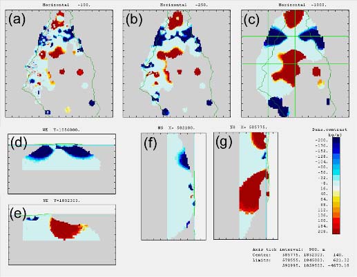 Picture: Inversion results of the reduced gravity data. (a-c) give the gravity anomalies at 100 m, 250 m and 1000 m depth bsl, while (d-g) give cross sections along the green lines shown in (c) in WE and NS direction, respectively. Best fit results were found for a density contrast of -200 to 200 kg/m3.
Both the Bouguer anomaly map and the best-fit results inferred from the 3D inversion reveal high-density bodies beneath the centres of the extinct volcanic complexes in the north of Montserrat (Silver Hills, Centre Hills. In contrast, the active Soufrière Hills and the flanks of the Silver Hills and Centre Hills are low-density zones.
The high-density bodies probably represent the sub-surface extension of exposed dome rocks in the Centre and Silver Hills, while the surrounding low-density regions may represent the volcaniclastic aprons around their flanks. The gravity field around the active Soufrière Hills Volcano may be influenced by melt aggregations in the subsurface, resulting in a low density anomaly beneath the volcanic edifice. The results agree well with observations from seismic tomography5,6; however, the higher spatial density of the gravity network enabled me to capture small-scale features at shallow depths, such as a tectonically uplifted block (Garibaldi Hill in south west Montserrat) together with its bounding faults, and the fluvial infill of eroded valleys in central Montserrat.
 OUTLOOK
Future work will focus on the collection of 4D gravity data. A smaller network of gravity benchmarks will be occupied about once or twice a year in order to document gravity changes over time relating to mass and/or density changes in the ground. Such spatio-temporal gravity changes can result from magma movement in the subsurface, but also from groundwater migration due to changes in pressurisation of the active magmatic system at SHV. The acquired knowledge on the subsurface structure of the island (the Bouguer map) will help to identify possible pathways for subsurface fluid migration and so better quantify the crustal response to volcanically induced stresses.
Note that accounting for time-dependent gravity variations will not impact the findings presented here on the static density distribution, as temporal gravity changes in volcanically active regions are about two to three orders of magnitude smaller than the spatial gravity differences reported in the Bouguer map
7. Finally, results from the static Bouguer survey and the spatio-temporal gravity campaigns will be combined and modelled in order to quantify poro-elastic behaviour of the crustal rocks and subsurface fluid dynamics in response to stress changes at SHV.
Acknowledgements
This work was funded by the German National Academy of Sciences Leopoldina (LPDS 2009-47) and by the Fearnsides Fund of the Geological Society of London. The author thanks Joachim Gottsmann (University of Bristol) and Antonio Camacho (Universidad Complutense Madrid) for sharing the geophysical equipment and the inversion software. The Montserrat Volcano Observatory and Eric Tomme provided logistical support during the survey, which is greatly acknowledged.
After extensive publicity in this magazine and elsewhere, applications for grants under the 2014 Research Funds closed on the first of this month. See www.geolsoc.org.uk/grants.
References
- Sparks, R.S.J. and Young, S.R., 2002. The eruption of Soufrière Hills Volcano, Montserrat (1995–1998): overview of scientific results. In: Druitt, T.H. and Kokelaar, B.P. (Eds.), The Eruption of Soufrière Hills Volcano, Montserrat, from 1995 to 1999: Geological Society Memoirs, 21, 45–70 (London).
- Mattioli, G.S., R. A. Herd, M.H. Strutt, G. Ryan, C. Widiwijayanti, and B. Voight (2010), Long term surface deformation of Soufrière Hills Volcano, Montserrat from GPS geodesy: Inferences from simple elastic inverse models, Geophys. Res. Lett., 37, L00E13, doi:10.1029/2009GL042268.
- Kearey, P., Brooks, M., and Hill, I. (Eds), An Introduction to Geophysical Exploration, Wiley-Blackwell, 3rd Edition (2002), pp. 272.
- Camacho, A.G., Gonzalez, P.J., Fernandez, J., and Berrino, G. (2011), Simultaneous inversion of surface deformation and gravity changes by means of extended bodies with a free geometry. Application to deforming calderas, J. Geophys. Res., 116, B10401, doi:10.1029/2010JB008165.
- Paulatto, M., et al. (2010), Upper crustal structure of an active volcano from refraction/reflection tomography, Montserrat, Lesser Antilles, Geophys. J. Int., 180, 2, 685-696.
- Shalev, E., et al. (2010), Three‐dimensional seismic velocity tomography of Montserrat from the SEA - CALIPSO offshore/onshore experiment, Geophys. Res. Lett., 37, L00E17, doi:10.1029/2010GL042498.
- Hautmann, S., Gottsmann, J., Camacho, A.G., Fournier, N., Sacks, I.S., and Sparks, R.S.J. (2010), Mass variations in response to magmatic stress changes at Soufrière Hills Volcano, Montserrat (W.I.): Insights from 4-D gravity data, Earth Planet. Sc. Lett., 290, 1-2, 83 – 89.
* School of Earth Sciences, University of Bristol, Wills Memorial Building, Queens Road, Bristol BS8 1RJ, UK