Product has been added to the basket

The wrong sort of rain


Approximate distribution of the world's water - figures in millions of cubic kilometres.

Hydrogeologist Michael Price* discusses UK geology and water supply in a changing climate.


Geoscientist 18.2 February 2008


In the spring of 1992 the east of England and Scotland were facing their fourth year of exceptionally low rainfall. I drafted an article about drought and groundwater and sent it off to The Independent. After it had matured for a few weeks, and we had had an unusually wet April and May, I was contacted: processes akin to tectonics had brought my piece to the top of the editor’s pile. Given recent rain, he reasonably asked, was the issue still relevant? Oh yes, I assured him; it would take months of heavy rain to make any impact on the situation before winter. The article was duly published and months of heavy rain were what we got. Ever since, whenever we have a dry spring, members of my family plead with me not to spoil it by writing “another rainmaking article”. In late 2007, with parts of the country disappearing under water, it seems a good time to take stock of the water-supply situation in Britain and to consider how we, and the rest of the world, might be affected by climate change.

We all need water and fortunately, Earth has plenty. The bad news is that – like money – most of it is locked up in reserves with relatively little in circulation. The water in stores is also mostly not of the right quality or in the right places for us to be able to use it easily.

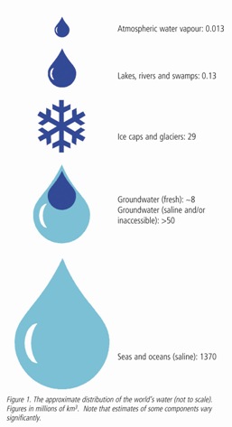
Of all the water on Earth (Fig. 1), the largest store is the oceans, which (including sea ice) are generally reckoned to hold around 1370 million cubic kilometres (km3). The next largest obvious stores are the icecaps of Antarctica and Greenland which, together with smaller land ice masses, are thought to hold about 27.65 million km3 (IPCC 4th Assessment). Although many cities – including London - are looking to sea water desalination (and there has been talk of towing icebergs from the Antarctic or elsewhere) neither of these large stores is of much direct use.

Instead, we look to more obvious sources – rivers, lakes and the ground. The circulation system – the “hydrological cycle” – means that all these are ultimately replenished by precipitation from a relatively tiny store of water in the atmosphere – about 0.013 million km3. The relative size of the oceans and the atmospheric store, and the quantity of average precipitation, mean that the average water molecule in the cycle spends about 3000 years in the ocean but only about 10 days in the atmosphere.

Three points are worth noting.

  • Water is a stable substance and the amount of water on Earth is pretty well fixed, so we are using the same water as the Romans and the dinosaurs.
  • Precipitation from that relatively tiny atmospheric store provides every man, woman and child on Earth with an average of about 60,000 litres of water a day.
  • For Great Britain, the average supply from precipitation is about 12,000 litres per person per day. In comparison, the average daily use of water from public supplies is about 340 litres/person-day of which something like 150 to 175 litres are used in the home and the remainder in offices, shops, schools, etc., supplied from the mains.

With figures like that, we may well ask why we have water shortages at all. There are two main reasons. The first is that we do not get to use all that water that falls from the sky; much evaporates, and we have to share it with other creatures. The second is that the ‘average’ doesn’t happen very often, or in many places. If everywhere on Earth received ‘average’ rainfall every day, water resources planners would be out of a job. It is interesting though to note the correspondence between average annual precipitation (Fig. 2) and world population density (Fig. 3). People tend not to live in deserts or tundra.

Fig 2 - Global average annual precipitation
Fig 3 - Global population distribution

A very British perversion

Perversely, in Britain the correlation is almost exactly negative – highest precipitation occurs in the north and west (and the lowest in the south and east), while population density is generally the opposite of this. The reasons for this owe a lot to geology, which controls the water supply of this country to a degree that few people – including most water engineers and many geologists – fully realise.

If we draw a line from near the mouth of the Tyne to the Isle of Portland then, roughly speaking, Great Britain to NW of that line is composed of pre-Permian rocks and the country to the SE is underlain by rocks that are Permian or younger. If you put a few wiggles in the line (Fig. 4) it works better. Older, harder rocks are more resistant to erosion and form high ground. The weather systems that sweep in from the Atlantic meet that high ground, are forced to rise over it and deposit much of their moisture as rain or snow. These older rocks are also largely impermeable, so water runs off them quickly. These areas therefore have rivers that are described as ‘flashy’ – they rise quickly after rain but equally, with little natural storage to sustain them, subside almost as quickly when the rainfall ceases. Many of the impermeable, steep-sided valleys make ideal sites for reservoirs.

Younger, softer rocks form much lower land that lies in the rain shadow of the western hills, so these areas are much drier. For this reason, hydrologists speak of a rainfall gradient from NW to SE across the country – a gradient that ultimately is largely dependent on geology.

High relief makes for communication difficulties and their underlying hard rocks also tend to produce poorer soils, better suited to grazing than intensive agriculture. Younger rocks are often permeable; they produce soils suited to intensive farming. They also provide better sites for building and easier communication routes. In combination, these factors mean that the south and east have become more densely populated than the north and west, creating a ‘population gradient’ counter to the rainfall gradient.

Fortunately however, the ‘storage gradient’ runs in the same sense as the population gradient. Low relief and often permeable ground may offer less scope for reservoirs; but the permeable rocks (aquifers) do two things. First, they absorb the rainfall and release it slowly through the year, meaning that most large southern rivers have fairly constant flows that can provide reliable supplies. They also provide massive natural storage – far more than in man-made reservoirs or natural lakes – that can be tapped by wells. When the water table in the Chalk outcrop falls by 1 metre, for example, it releases a volume of water equal to the gross capacity of Kielder Water, Britain’s largest storage reservoir.

Fig 6 - Geological and physical controls on water resources in Britain

Fig 5 - If precipitation (P) is greater than Evapotranspiration (E) then we have

‘Top slicing’ by soil


The source of most usable groundwater is ultimately precipitation from that small amount of atmospheric moisture; but not all of that precipitation will enter the ground. Some of it will be caught by foliage and will evaporate before it even reaches the ground. Some will evaporate from the soil surface, and some – often most – will be taken up by plant roots and transpired from leaves. In combination, this water that is returned to the atmosphere is termed “evapotranspiration”. The water that is left – the surplus of precipitation over evapotranspiration – is called “hydrologically effective precipitation” but is often referred to as “effective rainfall” (Fig. 5).

Effective rainfall can be can be disposed of in three ways.  Effective rainfall – not total rainfall – is the figure we need to bear in mind when calculating how much water is available. Fig. 6 shows an estimate of average annual effective rainfall for England and Wales superimposed on a map of the outcrops of the major aquifers. It shows how the areas of outcrop, by and large, coincide with areas of low effective rainfall - but the reality is worse than that. In dry periods, when total rainfall reduces, evapotranspiration does not go down proportionately – it is more likely to increase. Much of SE England has an average annual rainfall of less than 750mm but an average annual effective rainfall of less than 250mm. If the total rainfall in a year falls by 75mm (10%), the effective rainfall is likely to reduce by at least 75mm – a reduction of perhaps 50%. It is this potential change in effective rainfall, and the way it is distributed in time and space, that is the key to understanding how climate change will affect the water supply of Britain and many other areas of the world. Much of that key is gained by understanding how plants, soil and water interact to control evapotranspiration.

Fig 7 Potential infiltration to the principal aquifers in England and Wales (in mm). Redrawn from R A Downing, GJEG 26, 335-358

When it is not raining, plants keep growing by drawing water from the soil. This dries out the soil and creates a soil-moisture deficit (SMD). In simple terms, this is the depth of rainfall needed before recharge can occur again. Plant roots are very effective at extracting water but, as the soil dries out, it becomes harder for them. Then the plant initially slows down its rate of growth – so reducing transpiration – to compensate for the reduced water supply. If deprived of sufficient water for a long time, the plant cells start to lose their internal pressure and the plant begins to wilt. Sometimes this happens on very hot days even when the roots have adequate water, because the plant cannot move water fast enough from its roots to its leaves. In these cases the plant will usually recover overnight when transpiration stops. Failure to recover in this way means that the problem is caused not by excessive demand but by failure of supply and if water is not made available the plant will die. This will mean an end to transpiration; but by then the soil will be very dry and the SMD correspondingly large – perhaps more than 100mm.

Soil behaves like senior management anywhere – however scarce the resource, it ‘top slices’ to make sure it gets its share before anything is passed on to the lower strata. The soil will absorb the first rainfall and no recharge can take place until the SMD is satisfied. So, for example, once the SMD has reached 25mm, it will need at least 25mm of rainfall to start recharge. This represents about two weeks’ worth of average rainfall in southern England. On a warm summer day, evapotranspiration in this area can easily reach 5mm, so it is easy to see that unless that rainfall comes in an unusually short spell – as it did in many places in 2007 – the SMD will never be reduced sufficiently for recharge to take place in summer; the only exception to this is where soil is either absent or becomes cracked, allowing water to bypass it. The problem with the rainfall coming in a short, intensive spell is that the soil will simply not be able to absorb it quickly enough – in the jargon, its infiltration capacity will be exceeded. So even though the lower part of the soil and the aquifer beneath may have plenty of storage capacity, much of the rainfall will end up flowing through or even over the top of the soil to the nearest stream channel. This is why the water industry occasionally talks about ‘the wrong sort of rain’ – it may get into reservoirs (possibly causing soil erosion in the process) but it does not replenish aquifers.

In Britain, rainfall on average is fairly uniformly distributed throughout the year. Transpiration on the other hand occurs only when plants are growing actively - spring, summer and early autumn. Effective rainfall therefore occurs mostly in winter. In permeable areas, this water sinks into the ground, filling up the pore space until it overflows at low places on the ground surface. These places are usually river valleys and it is the discharge of groundwater that sustains river flows in permeable areas through dry periods. Because groundwater is flowing from an aquifer throughout the year but being recharged only for part of the year, the water level in the aquifer (the “water table”) fluctuates with the seasons. Headwater streams flow when the water table is above the stream bed, giving rise to phenomena like winterbournes.

Although the presence of a large SMD does inhibit recharge when effective rainfall returns in the autumn, it can have a beneficial effect: by absorbing some of the rain it can help to reduce the risk of flooding.

Climate change

With climate change occurring, all this becomes even more relevant. The latest IPCC predictions for changes in rainfall are, put simply, that wet areas will get wetter and dry areas, outside high latitudes, will get drier. Britain is predicted to have wetter winters and drier summers, with the net effect probably being an increase in precipitation, especially in the north. However, this increase will not come as the result of more wet days but because of increased rainfall intensity on the same number of ‘rain days’. This is likely to result in more frequent and more intense droughts in summer, especially in the south. Some potential recharge may be lost to surface runoff because of the high rainfall intensities. Storage will become even more important and groundwater even more valuable. Reservoirs should generally fill readily in the winter but will have to meet increased demand for longer periods in summer.

With increased SMDs at the start of autumn delaying the onset of recharge to aquifers, and possibly short but intense periods of recharge in winter when the SMDs have been overcome, it is probable that water levels in aquifers will display larger seasonal rises and falls. In turn, this will lead to stream networks – especially in headwaters – contracting and expanding more than we have come to expect, with consequences for ecosystems that depend on them. As we saw in 2000-01, ‘dry’ valleys may become wet, with flooded roads and cellars a side-effect. Fluctuations will be intensified by increased demand for water in dry summers - especially if we continue to expand housing in the south east. Bigger problems will arise when occasional dry winters are sandwiched between dry summers.

But, assuming that we do not get a ‘runaway’ greenhouse effect, with Earth ending up like Venus, the biggest problems of all are likely to be social. Already there are parts of the world where human existence is on a knife-edge. There are areas prone to devastating earthquakes or tsunamis, subject to volcanic eruptions, landslides, cyclones, drought or flooding. When another natural disaster strikes one of these places there is a tendency for us to ask why people live there.

Now the populations of these areas are increasingly asking themselves the same question and we are seeing their desperate attempts to move. The IPCC prediction is that equatorial and high-latitude areas will get wetter and sub-tropical areas will get drier. North Africa and southern Europe will become less attractive places to live (Spain may become a less desirable destination for Britain’s senior citizens) while northern Europe, including Britain, will become even more attractive to migrants and tourists.

In November 2007 the Office for National Statistics predicted that the UK population could reach 108 million by 2081. Others say that, if climate change and immigration continue unchecked, that figure could prove a serious underestimate. In either case, Britain’s water supplies could soon find themselves under much greater strain.


* Text and figures 1 & 5 © Dr Michael Price. Mike Price is Honorary Research Fellow, Dept of Earth Sciences and Geography, Keele University and Associate, Water Management Consultants, Shrewsbury (A Schlumberger Company).