Product has been added to the basket

Geocollaboration on the Weymouth Relief Road

Titanites sp., emerging from excavations in the Portland Stone Formation, Weymouth Relief Road. Photo - Richard Edmonds

Dorset County Council, through their Jurassic Coast Team, has recruited a stellar cast of well-known UK geologists to record the geology along the Weymouth Relief Road. Jamie Codd* reports.


Geoscientist 20.121 December 2010/January 2011


The Weymouth Relief Road is an £87.4 million single carriageway road designed to remove traffic from built-up areas and reduce journey times between Dorchester and Weymouth. The road will also improve access to Dorset’s Jurassic Coast World Heritage Site. The new 7.5km road passes through a sequence of strata dating back to the Middle Jurassic, 160 million years ago. Its construction created a temporary window of opportunity to study and record rocks and important structures normally only seen on the coast.

Dorset County Council, Skanska Civil Engineering and Amey Consulting have raced against time to ensure that stratigraphers, structural geologists and palaeontologists witness the exposures before they were covered. Plans have also been drawn up to preserve some important exposures for future generations of geologists.

Map of the route of the WRR and surroundings Progress on the scheme has been extremely rapid since March 2009 when Walters (UK), the earthworks sub-contractor, commenced the one million cubic metres of earthworks. Aided by dry weather and closely monitored by Amey’s engineers, Skanska and Walters have worked seven days a week at the northern end of the scheme to carve chalk from Ridgeway Hill and build a 23m-high embankment across the valley at Bincombe.

Working southwards, the rolling Dorset landscape has demanded substantial cuttings. These, combined with excavations for retaining walls and other structures, have provided a complete sequence of inclined Portland Stone, Portland Sand, Kimmeridge Clay, Corallian Beds and Oxford Clay. Deep foundations for bridges top and tail this extensive Jurassic sequence, revealing the Purbeck Group and lowermost Oxford Clay, respectively.

With work proceeding rapidly, and with site safety a prime consideration, access to key exposures has often been limited to short breaks during construction. However, renowned specialists have been called on, sometimes at short notice, to help Amey’s geologists interpret and record what has been found before foundations are filled with concrete and slopes are topsoiled. Regrettably however, there has been little opportunity to accommodate visits by large parties or fossil collectors.


Micraster coranguinum, from the Chalk

Jurassic Coast


The Weymouth Relief Road traverses the same strata found along the classic Dorset coastline (the “Jurassic Coast”), England’s only natural World Heritage Site. The Jurassic Coast stretches 150km from Exmouth in East Devon to Old Harry Rocks near Studland Bay in Dorset, recording over 185 million years of the Earth’s history.

At an early stage, the County Council’s planners and Richard Edmonds (Earth Science Manager, Jurassic Coast) realised that the proposed road might provide more continuous sequences of some strata than can be seen on the coast. Therefore, planning conditions included special requirements for recording the geology and, where possible, preserving sites to display the inland geology.

The construction team have been retaining fossils and other samples of geological interest discovered during the works. Recognised experts have been invited to inspect temporary exposures, log the stratigraphy, identify fossils collected and help build a more accurate geological map of the road. Specimens will eventually go to a local museum.

Richard Edmonds of the Jurassic Coast Team takes

Chalk


Chalk specialist Prof Rory Mortimore has undertaken several inspections of the chalk exposures at the Ridgeway. His finds (of echinoids, crinoids and bivalves) have allowed him to refine the stratigraphy of the Chalk in the area.

Close to the Ridgeway and Abbotsbury Fault complex, the chalk bedding is almost vertical, so much of the sequence is exposed over a short distance. Several regional marker horizons have been fixed, including the Lewes Marl and associated tubular flints in the Lewes Nodular Chalk Formation. The discovery of beds containing the bivalve Platyceramus platini has confirmed the presence of the Belle Tout Beds at the base of the Seaford Chalk Formation and fragments of the crinoid Marsupites testudinarius indicate the Splash Point Beds at the base of the Newhaven Chalk Formation and the Old Nore Beds higher up the sequence.

Purbeck Beds


Complex faulting at the Ridgeway has brought up a thin slice of Oxford Clay into contact with the Chalk and the steeply dipping Wealden and Purbeck Beds. The geology here, first described in remarkable detail by the Rev. Osmond Fisher2 in the 19th Century, has long been of interest to Dr Ian West. In a series of visits to a fine, but temporary exposures in the Purbeck Beds at Bincombe Lane, he has confirmed the remarkable observational powers and recording skills of geological pioneers such as Fisher (who wrote the first English textbook of geophysics). Excellent descriptions of the geology exposed at Bincombe and elsewhere along the scheme can be found on Dr.West’s award-winning web-site1.

Dr Bill Wimbledon has taken samples for palynological study and further investigation of the Jurassic-Cretaceous boundary which, remarkably, lies within the footprint of a new arch bridge. He has previously studied the upper part of the Purbeck succession in the nearby Upwey Quarries and Bincombe Down Site of Special Scientific Interest.

Mark Woods of the British Geological Survey has visited the site to update their records and compare the strata with the Durlston and Lulworth Formations recorded elsewhere3.

Purbeck Beds exposed in the excavations and in adjacent Upwey Quarries differ from those exposed at Lulworth and Durlston Bay because they were deposited closer to land. As a result the beds contain terrigenous material including plant, vertebrate and insect fossils.


Discoveries have included fossilised coniferous branches and pinnules, some of which have been sent to the University of Leeds for analysis by Prof Jane Francis. Bulk samples from fossil soils (dirt beds) have been passed to Paul Ensom, formerly of the Dorchester Museum, and have been found to contain micro-vertebrate remains. Drs Rob Coram and Ed Jarzembowski have both visited the Purbeck exposure at Bincombe to search for fossilised insects. They readily located the Upper and Lower Insect Beds, first noted by Osmond Fisher, and discovered an array of finely preserved insects including Trichoptera (caddisflies), Neuroptera (lacewings), Coleoptera (beetles), Orthoptera (grasshoppers and crickets), and Odonata (dragonflies and damselflies). Other fossils discovered in the Purbeck strata include fish scales, bones and teeth.

Although not part of the works, a trench was excavated by Skanska and Walters at Bincombe, to investigate the boundary between the Purbeck Beds and the underlying Portland Stone Formation. This temporary excavation successfully exposed the boundary, but unfortunately the famous “fossilised forest” (stromatolites) exposed at Lulworth were absent.
Microconch - with distinctive lappets (male). Compare with the macroconch of the same species (below)

Portland Group


The Portland Stone Formation was exposed in a cutting south of Bincombe and the contractors managed to save a number of the huge ammonites for which Portland is so famous. The ammonites are of the genus Titanites and specimens up to halfa metre iin diameter were recovered. Several smaller ammonites, bivalves and marine gastropods were also recovered. South of the cutting, the Portland Sand Formation was exposed, faulted against the Portland Stone and revealing pockets of Portland Clay.
Macroconch of species illustrated above - note larger size and absence of lappets.

Kimmeridge Clay


Continuing south, the cutting passes into the Kimmeridge Clay, a formation of particular interest to Dr Ramues Gallois (formerly of BGS). The Formation typically comprises organic rich silty mudstones with bands of thin siltstones and limestones.

Although excavations in the Kimmeridge Clay were relatively shallow, compared to the cuttings further north, site visits have proved very productive, yielding bands of septarian nodules, coccolith-rich limestones, organic rich horizons and the finely detailed crinoid, Saccacoma, preserved in pyrite,. Many familiar marker bands were identified, including the Encombe Stone Band, Freshwater Steps Stone Band, the Middle White Stone Band and the Blackstone Member. On one occasion, a bone thought to be part of the rostrum of an ichthyosaur.

Excavations for balancing ponds exposed numerous beds of oil shale together with a very distinctive weathered mudstone bed. This was weakly cemented and contained clay casts of many ammonites and bivalves, a distinctly different form of preservation from those in adjacent beds. Of particular interest was the variation in size of different ammonites of the same genus, representing a range in ammonite maturity.

Aerial photo showing distinctive colours of the Corallian of Southdown Ridge (Photo - Still Imaging).

Corallian Group


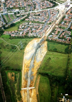
The relief road cuts through a prominent east-west ridge (the Southdown Ridge), revealing an almost uninterrupted section through most of the Corallian Group. Ian West, John Wright and Kevin Page have helped interpret this section which, freshly cut by excavators, can appear quite different from the weathered coastal exposures. Sedimentary structures and other features that may be on a coastal cliff may not be immediately apparent in a machine-created pit or wall.

Although most of the Sandsfoot Formation is absent, the junction between the Corallian and overlying Kimmeridge Clay, marked by the Ringstead Waxy Clay, was briefly exposed in the excavation for a culvert north of the ridge. The Clavellata Formation, characterised by the abundance of the bivalve Trigonia clavellata, is the most resistant of the Corallian strata at the north end of the cutting. Many fossils were found here including rare ammonites, a large nautilus and an ichthyosaur vertebra.

Beneath the Clavellata Formation lies the Osmington Oolite Formation, typically oolitic and bioclastic limestones with interbedded oolitic and pisolitic calcareous mudstones and clays. The distinct colour contrast between the white and light grey limestones and the dark grey argillaceous material makes the oolitic marker horizons relatively easy to pick out, compared to the beds of the Clavellata Formation. The ooids are usually up to about 5mm in diameter,r medium to coarse sand-size, and have a concentric structure. A well timed site visit found a horizon with many fine examples of the small echinoid, Nucleolites scutatus, less than 2cm across and 1cm tall.

Several faults occur in the Southdown Ridge, leading to variations in dip and repetition of some beds, including the Bencliff Grit. This marks the base of the Osmington Oolite Formation and the top of the Nothe Formation. The horizon is sometimes identified by the occurrence of hard cannonball-like sandstone concretions. However, where these had not been crushed by machinery , they seemed to have taken on a more tabular form than elsewhere.

The Bencliff Grit at Southdown Ridge is most easily identified by its distinctive colour, a bright orangey or reddish brown, caused by oxidation of iron. Similar to the Bencliff Grit is the Preston Grit. The two are separated by the Nothe Clay, though little of this has been exposed along the road to date. The Preston Grit can be distinguished by the occurrence of the bivalve Gryphaea dilatata. The bivalve also characterises the underlying Oxford Clay to the south.


Oxford Clay


Earthworks last autumn have been concentrated at the southern end of the scheme, close to the axis of the Weymouth Anticline. These uncovered a partially faulted boundary between the Nothe Formation and the Oxford Clay.

Where the boundary is conformable the Bowleaze Clays, at the top of the formation, have been identified by the occurrence of bands of distinctive , red siderite nodules within the pale grey clay. The Oxford Clay is typically iron-rich, thanks to the anerobic conditions under which the strata were deposited. These conditions have led to the development of pyrite nodules, siderite bands and nodules, elaborate crystals of radial selenite and gypsum crystals. Since the cutting was excavated, chalybeate springs have developed at in the cutting walls. All these factors combine to create a particularly hostile environment for steel and concrete, and have required careful consideration by the scheme’s designers.

Piling rigs working at the southern limit of the scheme have recovered mudstones containing a well-preserved Lower Oxfordian macrofauna dominated by the ammonite Kosmoceras jasoni - see illuetrations above.  Thanks to the exceptional preservation, Dr Kevin Page has been able to distinguish both sexes, the larger forms (macroconchs) being female, and the smaller microconchs being male. Ornamentation on the body chamber is limited to the outer whorl of macroconchs, but developed on the microconchs. The aperture of the body chamber tends to be more elaborate on the microconchs, with distinctive prolongations or "lappets".

Amey’s design team is continuing to work closely with Dorset County Council and Skanska to develop and retain key exposures where it is practical and safe to do so. In particular, it is hoped to develop a site near a cycleway at Bincombe revealing the Jurassic –Cretaceous boundary. Dorset County Council and their Jurassic Coast Team are acutely aware of the importance of their local geology, and, thanks to the support of Skanska, Walters UK and a number of experts, Amey’s geologists have been able to record the geology that will eventually, alas, be hidden by the new road and its landscaping.

Collaboration on this project has been particularly significant, given the sensitivity and value of Dorset’s geology and the scientific benefits it has yielded. At the same time, this has been coordinated to fit safely around site works with no consequent delays to the construction schedule. Despite exceptionally heavy rainfall in November that curtailed the earthworks, the relief road remains on schedule be completed in Spring 2011.

References

  1. WEST, I (2009) Ridgeway Railway Cutting and Weymouth Relief Road Cuttings between Dorchester [online] Available at http://www.soton.ac.uk/~imw/Ridgeway-Railway-Cutting.htm [accessed 14.12.09]
  2. FISHER , O. (1856) On the Purbeck strata of Dorsetshire. Transactions of the Cambridge Philosophic Society, 9, 555-581.
  3. WOODS, M.A. (2009) Weymouth Relief Road: temporary excavations in Jurassic and Cretaceous strata (May 2009). Cretaceous Survey and Research Programme, Open Report OR/09/035. British Geological Survey, Keyworth.
* Jamie Codd is an engineering geologist with Amey Consulting.