Product has been added to the basket

Walking the roofbeam

D N WadiaGeoff Glasby celebrates the life of D N Wadia, pioneer of Himalayan geology, on the 90th anniversary of the publication of his monumental book The Geology of India. Himalayan geologist Mike Searle (Oxford University) presents a modern perspective on his work.


Geoscientist 19.8 August 2009


Darashaw Nosherwan Wadia was born in October 1883 in Surat in Gujarat State. In 1894, in order to get a better education for their son, the family moved to Boroda (also in Gujarat) and he attended a private Gujarati school and then the Sir J J English School. Here he developed his love of science and devotion to knowledge. At the age of 16, Wadia went to Baroda College, which was then part of the University of Bombay. There he took a BSc in Botany and Zoology (1903) and a second Bachelor degree in Botany and Geology in 19051. At that time, geology was only taught in Calcutta and Madras, which means that Wadia was therefore largely self-taught as a geologist.

In 1907, at the age of 23, Wadia had the good fortune to be appointed Professor of Geology at the Prince of Wales College in Jammu in the southernmost part of the State of Jammu and Kashmir1 and stayed there until 1921. From there, he set his eyes on the distant Himalaya. His early life among the mountains of Kashmir inspired much of his later work on the structure and stratigraphy of the North-West Himalaya2.


Sketch map of the Nanga Parbat region. See how the Himalaya bend around the syntaxis, as though it were a pivot.


Wadia’s main task as a lecturer in Geology was preparing the students for the Punjab University Examinations. However, he experienced great difficulty teaching the geology of India because of the lack of suitable textbooks. He therefore took the extreme solution of writing his own. The first edition of The Geology of India for Students was published in 1919 and the sixth edition, The Geology of India, was published in 196611. The Geology of India is a remarkable book. The sixth edition is 536 pages long and divided into three main sections, the first, relatively short, on the Physical features of India, the second a huge contribution on the stratigraphy of India from the Archaean to the Pleistocene and Recent and finally a relatively short section on the Economic Geology of India. This book had a profound influence on generations of students of geology in India and is still in use today.

During his time in Jammu, Wadia used to take his students on adventure trekking and investigative field trips in the Siwalik Hills of the Jammu region. Among the fossils he collected during these years were a 10 ft-long long tusk and skull fragments of an elephant-like mammal, Stegedon ganesa, which he found in the Upper Siwalik Formation six miles north of Jammu. In 1928, Wadia subsequently identified a skull of Actinodon risinensis, collected from the Lower Gondwana beds near Zewan in Kasmir (West 1965). These two fossil discoveries were of great import ).


Nanga Parbat -

Geological Survey 1920-38


In 1920, the Geological Survey of India received authority to increase its compliment of scientific officers from 20 to 32. Wadia was appointed to one of these positions at the relatively late age of 37 in 1921. He was the first Indian to be appointed to the GSI whose degrees came from an Indian university1. At that time, the GSI was mapping in some Himalayan areas where topographic maps at one inch to the mile had become available. Wadia began his career at the GSI by mapping 2000 square miles of the mountainous Poonch State in the Lesser Himalayas and an additional 2100 square miles in the adjacent parts of the Punjab. This formed the basis of his first substantial memoir for the GSI in 19283. One of the principal findings of this study was his explanation of the unique knee-bend of the mountain chains around the knot called Nanga Parbat, as the result of the interaction of the Himalaya with the the tongue-like projection of the Archean Shield1,2,4. The tectonics of the Nanga Parbat Syntaxis have recently been the subject of a Memoir of the Geological Society5. For his work there, Wadia was awarded the Back Award of the Royal Geographical Society in 1934 and the Lyell Medal of the Geological Society in 19432.

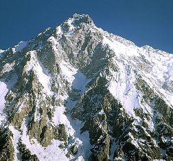
In 1930-31, Wadia continued mapping the high ground around Nanga Parbat (peak at 8113m) with only old ½ and 1 inch topographic maps available to him1,2. He described the mountain as “a peak of arresting grandeur…Its southern flank exposes a rock face whose buttressed cliffs, 12,000ft high, pierce the sky almost in one leap”. Its surrounding slopes were concealed under many square miles of uninterrupted snow fields. Wadia described the Nanga Parbat mountain mass, the central and most commanding feature of the whole district as above 15,000ft (4572m) and “almost inaccessible to the single field geologist, unequipped with elaborate mountaineering outfit, parties of carriers, etc.”4. However, Wadia was able to deduce the geology of the higher parts of the mountain above the snow line by examining the moraine deposits. On this basis, he considered the geology of the mountain to be “rather simple”: to which his Director replied that it must be rather pleasant to possess the philosophical temperament to regard such complexity as simple1. Nonetheless, fieldwork in this barren area undertaken at the age of 50 would have required great tenacity2.


Nanga Parbat Raikot. Photo - Mike Searle A decade later, in 1937, he contributed two papers on the tectonic relations of the Himalayas with the North Indian Foreland, and on palaeogeography and climate during the Permo-Carboniferous, at the International Geological Congress in Moscow, though he was unable to attend in person.

Fossils and soil


Wadia’s interests were very broad however, and from 1926-1927 he extended his studies of vertebtrate fossils from the Siwalik (Neogene) strata of Potwar and Kashmir at the British Museum (Natural History), and at geological institutions in Germany, Austria and Czechoslovakia1. In 1938, he also published a catalogue of fossil primates discovered in the Tertiary deposits in India2. Wadia’s contribution to the soil science in India was also highly significant6. Wadia bemoaned the neglect of soil science in India and showed the way for improvements. As a result, in 1935 Wadia (jointly with M S Krishnan and P N Mukherjee) published India’s first soil map. Wadia thereby exerted considerable influence on agricultural development in his country and represented India at the 3rd International Congress of Soil Science held at Oxford in 1935 and also participated in an excursion arranged by the Congress to study the soil profiles in England, Wales and Scotland.

In 1938, Wadia reached the GSI retirement age (55). In that year, he gave the Presidential Address to the Geology Section of the Indian Science Congress during its Jubilee Meeting in Calcutta1. He also provided a chapter dealing with geology and geography to the Congress Volume entitled Progress in Science during the last 25 years and gave a president’s address on the Himalayas to the Geology Section.


Ceylon 1938-1945


On his retirement, Wadia accepted an offer from the Government of Ceylon to become its Government Mineralogist. His main recommendation was that a systematic survey of the island should be undertaken in order to prepare an accurate geological map of the island. This work was impeded by lack of qualified staff, but he managed to produce a number of reports on water supply, peat, glass sands, gem gravels and minerals of economic value1. He also produced accurate geological maps of the island and geological investigations concerning water supply, dam-sites and other engineering projects6. His transfer to Ceylon was to bring other, more personal benefits. In 1940 Wadia, already a widower met and married his second wife Meher Medivala. She was a mineralogist and graduate of the University of Bombay and was his constant companion for the rest of his life. An established scientist in her own right, she published her Minerals of India in 19667.

In 1942, Wadia became General President of the Indian Science Congress. At its 1943 meeting in Calcutta, Wadia spoke on Minerals’ share in the war8. He pointed out that this was the first time in the four millennia of India’s recorded history that an enemy had assaulted the eastern frontiers of the country, and reported on India’s response, through its munitions factories, its electric, chemical and technical plants and industrial research laboratories. He also pleaded for a justly planned international minerals policy, to preserve peace and goodwill among countries1. This speech, published in Science, was an impressive and far-sighted contribution, especially for having been made in a time of war.


NP from the air - the old flight from Rawalpindi to Skardu. The flight circumnavigated the poeak. Photo - Mike Searle

Into the sixties

In 1945 Wadia was appointed Geological Adviser to the national government of Jawaharlal Nehru and asked to initiate and formulate a mineral policy for India6. He realised that the estimates of raw mineral resources needed reassessment1. Following Independence in 1947, supplies of some minerals (salt and gypsum) were indeed found to be in short supply with the passing of territory to Pakistan. In 1947, he announced the setting up of a Mineral Advisory Board to advise on mineral development. In 1948, Wadia became the first Director of the Indian Bureau of Mines, where he was assisted by two officers. The Bureau drafted the Mines and Minerals Act (1948), the Mineral Concession Rules (1949 and the Petroleum Concession Rules (1949). In 1949, Wadia left the Bureau to serve on the Atomic Energy Commission. Under his leadership the Indian AEC grew into a well-knit unit of 470 geologists and geophysicists, mining and drilling personnel. Thus Wadia had a hand in establishing almost all of India’s postwar minerals policy.

NP Steep GlacierIn 1948, Wadia attended the London International Geological Congress, presenting a paper on the fluviatile sediments of NW India1. As head of the Indian delegation, Wadia also conveyed an invitation on behalf of the Indian Government to host the XIXth Congress in New Dehli to coincide with the centenary of the formation of the GSI. However, on that occasion the conference was awarded to France, and it was not until 1964 that India was able to host the IGC (the XXIInd International Geological Congress) in Dehli - with Wadia as its President.

In 1963, Wadia gave the Meghnad Saha Lecture9 on The Himalaya Mountains: Their age, origin and sub-crustal relations, in which he essentially summarised his ideas on the formation of the Himalaya developed over a lifetime. In 1965, a D N Wadia Commemorative Volume, containing 60 separate articles, was published by the Mining, Geological and Metallurgtical Institute of India10.

Wadia was also heavily involved in founding the Indian Institutue of Himalayan Geology in Dehra Dun of which he was made the first honorary director. The institute was named the Wadia Institute of Himalayan Geology after his death.

Wadia was a field geologist through and through. For months on end, he would leave his camp at day-break for a good 20 miles traverse on foot in trackless mountain or on a much longer ride on mule or horseback, a late lunch his first meal of the day. ‘The best work is done with the least amenities’ was his favourite dictum. He died on June 15, 1969 at the age of 86. He was without doubt the best geologist India has produced.

“A giant among geologists, Darashaw Nosherwan Wadia was a great visionary who not only shaped our understanding of the geological making of the Indian subcontinent but also set the national agenda of geological activities when India won freedom.”


K S Valdiya

“Fortunately for India, it found in Wadia an eminent geologist of its own, who would enthuse generations of Indian geologists…clambering up and down the Nanga Parbat area of the Himalayas, at the height of twelve thousand feet, when he was fifty.”


Biman Nath