Product has been added to the basket

Nuclear and present danger


George Tuckwell (foreground, right) and the team in KazakhstanAs uncertainty over North Korea’s nuclear intentions raises international fears once again, STATS geophysics’ team leader George Tuckwell* (picture, right) recounts his recent role in one of the most important nuclear non-proliferation projects in history.

Geoscientist 19.8 August 2009


When the Comprehensive Nuclear-Test Ban Treaty (CTBT) comes into force, it will make any kind of nuclear explosion an illegal act. One hundred and eighty states are currently signed up to it and 145 (including every European nation) have ratified it. Only North Korea, Egypt, India, Indonesia, Iran, Israel, Pakistan and the United States have yet to commit by signature or ratification. But if his campaign rhetoric is to be believed, US president Barack Obama has plans to ratify the treaty in the near future, which will surely increase pressure on the rest.

While the Treaty itself remains idle, the “Preparatory Commission for the Comprehensive Nuclear-Test-Ban Treaty Organization” (CTBTO) has been anything but – establishing a global monitoring system across over 300 worldwide locations, ensuring that any sign of nuclear deviance will be met with a swift investigative response.


George gets kitted up Once the CTBT is active, the CTBT the UN may be requested to investigate on behalf of a member state whenever suspicious activity is recorded. After final data analysis at the International Data Centre (IDC) in Vienna a decision may be made to instigate a site inspection. This would be carried out by a 40-strong team, assembled from the CTBTO’s global network of seismology, hydroacoustics, infrasound and radionuclide monitoring experts.

The site investigation team would then deal with four specialist components: visual observation, micro-seismic monitoring, radionuclide monitoring and continuation phase technology (CPT – in other words, geophysical site investigation). This is where the expertise of my company, STATS, comes in.

Last year, our geophysics team was contracted by the United Nations (UN) to write the CPT’s standard operating procedures, and I was appointed as the field team’s lead geophysics inspector. And so it came about that in September 2008, I was asked to do my duty in the CTBTO’s first ever Integrated Field Exercise (IFE08) - since hailed as one of the most ambitious projects in the history of nuclear non-proliferation.

Taking the form of a “role-playing” exercise on the biggest scale imaginable, IFE08 entailed spending three weeks at the former Soviet Union nuclear test site of Semipalatinsk, (Kazakhstan) which was recast for the purposes of the exercise as the fictitious state of “Arcania” (with its ‘representatives’ played by CTBTO staff and other international organisations).


Coming into land at the site A magnitude 4.0 earthquake, accompanied by an inexplicable release of the radioactive substance Caesium 137 was recorded - and the inspection team was duly engaged. Once the other teams had narrowed the search area to a manageable size, we had our cue.

Wearing overalls and outer disposable coveralls at all times, together with the most important piece of protective equipment of all - the dust mask - each day we had to design, negotiate, implement and then report on field activity, all within the non-scientific terms of the treaty. This entailed short bursts of intense, time-constrained activity.

Although the other teams found no clear evidence of recent underground nuclear testing, we had plenty of leads to follow up. First, we acted on data from the microseismic monitoring team and conducted an aerial magnetic survey to define the geology of any suspicious areas. Nothing untoward was found.

Then it was on to one particular borehole site that had not been declared during the initial negotiations with the Arcanian State Party, and was not obvious from the surface. There’s no hiding from magnetic and electrical resistivity tests though, and the borehole was soon located beneath some hurriedly placed soil and vegetation. The radionuclide team was called in, but found no evidence of a recent test.

Other investigations concentrated on sites with underground nuclear test histories stretching back decades. The geophysical signature of these boreholes was broadly similar to the undeclared site implying that it could be adopted for underground test-use in the future.


The team One of the boreholes used for actual testing some 30 years ago provided a stark warning of the enduring aftermath of a nuclear explosion, with groundwater chemistry and hydrogeology impacts still noticeable in the electrical and magnetic properties of the subsurface.

The end of the simulation came when we handed over the preliminary findings report – which concluded that the information gathered did not support the assertion that “Arcania” had conducted an underground nuclear explosion. All the tell-tale signs were absent, as were the relevant radioactive substances.

The contribution of geophysics


The geophysical techniques we used for IFE08 are the same as those used, for example in reducing the risk of unforeseen ground conditions to engineering and construction projects. The activities of a rogue state seeking to conceal an underground nuclear explosion are likely to result in detectable disruption to the shallow and deep subsurface.

It also requires substantial effort to prepare, instrument and undertake a nuclear test. Although it is likely that a rogue state would try to remove or conceal any above-ground evidence, rig foundations, cable trenches, vehicle tracks, waste and contamination, excavations and other ground disturbance are likely to remain in the upper few metres. These remains should be readily detectable using such techniques as ground penetrating radar, EM ground conductivity and magnetic gradiometry, and others.


Collecting geophysical data The test itself would be expected to modify the density, and to some extent the chemistry, of the rock at depth. Because of the heat released, one would also expect that the groundwater table would be disrupted. Changes to groundwater chemistry may also be detectable. The cavity formed by the explosion may be imaged directly, as may the immediate zone of influence within the rock and groundwater. Tunnels, shafts or other excavations created to place the device at depth may also be detectable.

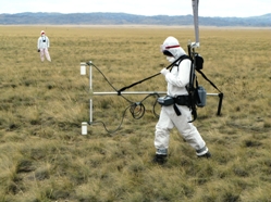
Depending on the specific case, any combination of microgravity, deep electrical imaging or active seismics would be appropriate techniques to use. They are used in mining and mineral exploration, as well as possibly during underground coal gasification projects or in the geological disposal of nuclear waste.

The inspected state may put forward its own explanation for the suspect event - a natural earthquake, for example, or an induced event caused by mining or a natural void collapse; and indeed it is perfectly possible that no illegal activity has occurred (as in our exercise). If the official line is that the area under investigation is an old industrial site, the tell-tale geophysical signatures (service runs, pipelines, foundations, storage tanks, buried waste, contamination, etc.) are something we have become very familiar with in our woirk on brownfield sites across the world. Such experience is crucial; since drilling is not allowed until the final phase of the inspection process (if at all) the correct and careful application of geophysical techniques is critical to the success of an inspection.

In the months to come, State Signatories and the CTBTO will revisit the exercise by sifting through the many reports, assessments and documents that were produced. Future exercises will be conducted to determine how much has been learned from the lessons gained at the Integrated Field Exercise 2008 in Kazakhstan.

*George Tuckwell is a director of the Geophysical division at STATS Ltd (RSK Group), and is a Vice President of the Geological Society. The views expressed herein are those of the author and do not necessarily reflect the views of the CTBTO Preparatory Commission.