The first geological map of Scotland
Geoscientist 17.8 August 2007
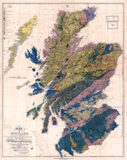
The British Geological Survey has published a poster reproduction, at half-scale, of the first large-scale geological map of Scotland, says Brighid Ó Dochartaigh.
MacCulloch's map was first printed in 1836 as four hand-coloured sections, each 34” by 27”, at a scale of four miles to the inch. The third issue from 1840 has now been reproduced, preserving additional pencil sketches, annotations and hand-drawn cross-sections.
The original map was made almost single-handedly over a period of more than 16 years by John MacCulloch MD FRS - army surgeon, chemist to the Board of Ordnance, lecturer at the Royal Military Academy, London physician and, not least, the first government-sponsored geological surveyor in Britain and one-time (1816-1817) President of the Geological Society.
The map’s reprint is welcome for its historical value and because it is a real thing of beauty, hand-coloured and printed on Samuel Arrowsmith’s striking topographic map (although MacCulloch often complained about errors in Arrowsmith’s work). It dates from a time of rapid advances in geological understanding – William Smith’s map was published in 1815 – when the efforts of MacCulloch and Smith to provide comprehensive and reliable geological mapping helped lay the foundations for our modern-day science as well as for mineral exploitation that underpinned the Industrial Revolution and, later, the oil economy. On the large scale MacCulloch's level of accuracy is quite impressive, instantly recognisable in its depiction of Scotland’s geology, and a tribute to its maker.
MacCulloch’s first geological ventures in Scotland were during the Napeolonic Wars, when hostilities had stopped imports from Belgium of the preferred millstones for the Army’s gunpowder mills, and he was sent to find replacement sources of non-siliceous limestones. By 1812 he had found suitable stone in Sutherland, Skye, and at Glen Tilt, although in the end none was successfully exploited: the millstone project was abandoned after the defeat of Napoleon at Waterloo. In 1814 MacCulloch was appointed Geologist to the Trigonometrical Survey, into which role he threw himself with great resolve. One of his most important early outputs was a series of maps of the Western Islands of Scotland, published in 1819 – this was 40 years after Boswell and Johnson made their journey to the same islands, but conditions for the map-maker were undoubtedly still quite basic.
Legend has it that in 1821 MacCulloch applied to the Treasury to have his national map printed, but nothing came of it - even though he threatened to do away with himself if it was not published! Perhaps this was because – despite his protestations – the map was not quite ready, and until 1832 most of his summers were spent continuing to survey across Scotland. His map and accompanying memoir were finished in 1834, and finally issued in 1836. Sadly, however, he never saw his life’s work in print. On 21 August 1835, while on honeymoon in Cornwall, MacCulloch died after "falling" under the wheels of his own carriage.
The value of his map was recognised by peers, whose names today are far more famous than his. Charles Darwin used it in his own geological work, including a paper in 1848 "on the transportal of erratic boulders from a lower to a higher level" in Glen Roy (Quart. Jour. Geol. Soc. Lon. 4 315-323); and Charles Lyell, in an obituary notice in 1836, acknowledged "with gratitude" that he had "received more instruction from MacCulloch’s labours in geology than from those of any living writer" (Proc. Geol. Soc. ii. 357).
Ref: The map is available from BGS, price £10
http://shop.bgs.ac.uk/Bookshop/
E:
[email protected]