Product has been added to the basket

Bhutan contact - geology on the roof of the world

Argles and Warren

Tom Argles*, supported by the Society’s Mike Coward Fund, joined Clare Warren on an ambitious trek into the heart of the Himalaya.


Geoscientist 20.03 April 2011


Bhutan, a country slightly smaller than Switzerland but no less mountainous, is rightly famed for its wildlife. The landscape of the northern reaches of the kingdom is also pretty wild, making geological fieldwork challenging at best.

In May 2010, Clare Warren and I trekked into the mountains of northern Bhutan on the trail of some of the youngest crystalline rocks in the Himalaya. Oblivious (more or less) to the bears, tigers and various species of leopard reputedly roaming the region, we explored high valleys hardly visited by geologists since the pioneering work of Augusto Gansser in the 1960s. In between teasing out the secrets of the high-grade gneisses and leucogranites, we even found time for some filming (see Postscript, below).


Looking north up the Mo Chu valley towards Laya from the trekking path My main research aim was to investigate the zone where two groups of high-grade gneisses were juxtaposed. Could structural studies explain why these two groups of rock had recently yielded different radiometric dates1? I also wanted to verify some geological and structural features on Augusto Gansser’s original map2, in particular his report of layered metasedimentary units in the upper Rodophu valley. Metamorphosed sediments in this position – deep in the heart of the mountain belt – could provide valuable samples for determining the Pressure-Temperature (P-T) conditions under which they formed. P-T and time information on such rocks is critical for helping geoscientists evaluate competing models of how the Himalaya were made and how the mountains continue to evolve.

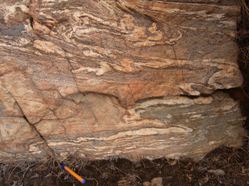
Highly deformed leucogranite veins in migmatitic gneiss, Laya shear zone

CONTINENTAL COLLISION


Not surprisingly for such a striking example of a young continental collision zone, the Himalaya has proved a hotbed of theories for mountain-building processes for over a century (see box text). A popular recent model attributes the highly-deformed, high grade gneisses of the Himalayan core to ‘channel flow’, where rocks at a certain depth in the middle crust partially melt, triggering ductile flow of these rocks back towards the mountain front, where they are then exhumed by rapid erosion. This process has been likened to squeezing toothpaste out of a tube.

However, evidence is emerging in Bhutan that motion on major shear zones, which dragged the high-grade rocks up from the middle crust, was not restricted to a single, simple episode of channel flow, but switched both southwards and northwards, exhuming different bodies of rock at different times. This may reflect doming and re-organization of the mid-crustal channel3, or the dynamic response of a large-scale orogenic wedge, for instance by out-of-sequence thrusting in northern Bhutan.

By trekking to the area around Laya village, we hoped to locate and map one of these major fault contacts, confirm how gneisses above and below the fault had been displaced by the fault, and collect samples for further analysis – to find out how hot and deep the rocks were when they were deformed.

Analysis of thin sections of the rocks should tell us the P-T conditions in the footwall and hanging wall of the shear zone, as well as the conditions during actual shearing. Combining these data with existing dates on the gneisses juxtaposed across the shear zone will provide us with a crucial piece of the Himalayan puzzle in Bhutan.


Map of route taken by Clare Warren, Tom Argles, their trekking crew and dwindling packhorse train
Sketch cross-section through the Himalaya, showing how channel flow could account for surface geology

Himalaya: how to make a mountain belt


The Himalaya (and the Tibetan plateau to the north) were born around 50 million years ago in the collision between India and Asia. The elevated topography of this vast region is a surface expression of thickened crust in this continental ‘crumple zone’. Geoscientists working on the collision zone over a decade ago relegated the spectacular mountain range to a relatively minor role – as merely the fretted edge of a plateau (Tibet) that was collapsing under its own weight after losing its supporting lithospheric mantle root4.

Several geophysical studies supported this model, showing that the plateau was apparently spreading outwards in all directions. This marginal spreading is a major cause of recent earthquakes in the area, including those in Kashmir (October 2005) and Sichuan (May 2008). A recent refinement of the collapse model (the popular channel-flow hypothesis5) was founded on two major premises: that a drastic viscosity decrease occurs in mid-crustal rocks that develop small proportions of melt, allowing them to flow in a ‘channel’ at depth, and that second, intense erosion focused in a narrow zone will act to exhume one end of such a channel rapidly to the surface5.

Many geological predictions of this model (in various permutations) chimed with what field geologists had observed in the Himalaya. Foremost among these was the observation that the intensely-deformed, high-grade core of the mountain belt (the Greater Himalayan Series) had been rapidly exhumed by coeval motion on a basal thrust and an overlying low-angle normal fault at around 23 to 17Ma.

Opposing models picture the Himalaya as a wedge of crustal material constantly deforming internally to maintain a critical ‘angle of taper’ – i.e. a shape that represents dynamic equilibrium between all the forces acting on the collision zone. This group of models emphasises the role of major thrust faults propagating through the orogenic wedge, in effect ‘shuffling’ thrust sheets to adjust the overall cross-sectional shape of the mountain belt.


Our horses tuck into breakfast at Rodophu camp. Inset: aftermath of night grazing and leeches, Gasa.

WORST CAMPSITE


We lost a day, early in the trip, as our cook succumbed to an indeterminate fever; but trekked up to Laya village (3800m) via Koina – “the worst campsite in the Himalaya” according to Lonely Planet. We located a major, thrust-sense shear zone on our very first day working west from Laya. This ductile structure separates sillimanite gneisses in the footwall formed at 21-17Ma from slightly younger (c. 14Ma) granitic gneisses in the hanging wall. Significantly, we observed undeformed leucogranites cross-cutting gneisses in both the footwall and hanging wall of this shear zone, whereas all the leucogranites we found within the shear zone were deformed into the shear fabric. Dating of these granites will therefore help constrain the timing of thrust motion here, which must post-date the main episode of channel flow in the Himalaya (c. 21-15Ma).

On the third day after this discovery, another setback. Our crew informed us that our supply of bottled gas was running low, and we would have to cut the scheduled trek short! We debated trying to save a day by climbing over a high pass from our camp at Tashimaka to Rodophu valley, while the horses trekked the long way round – but caution prevailed. We had already mislaid a couple of horses; in fact, we were to end the trek with only seven of the original 11 still present. (These loyal souls were rewarded with the tender ministrations of leeches in the torrential rain that greeted us on the return to Gasa.) We left Tashimaka with only one full day’s observations (the other highlight being a rare find indeed – the scat of a Snow Leopard), and headed for Rodophu valley.

Layered rocks at the head of Rodophu valley – Gansser’s metasediments – proved to be mainly banded granitic gneisses with leucogranites; however, we confirmed the distribution of sillimanite gneisses (to the south) and more granitic gneisses (to the north). An additional curiosity was the discovery of a body of strange, granular potassic rock, deformed and metamorphosed at the margins, within the high-grade gneisses. This was unlike the small mafic granulite boudins we saw frequently in the float throughout the area, which date from the Palaeoproterozoic. This was just one more intriguing piece of the Proterozoic puzzle to further complicate the ancient history of rocks from the Himalayan core.

On our reluctant return trek, we at least had the opportunity to boast of Snow Leopard poo and vulture sightings to Steve Backshall and a heavily-laden BBC crew, heading up for some high-altitude filming round Laya. Our early return also gave us time for a couple of detailed road sections near the capital Thimpu – in this case detailed transects across the purported tectonic contact between the Greater Himalayan Series and the underlying, lower grade ‘Paro metasediments’. We recorded a gradual transition down-section from sillimanite gneisses with minor leucosomes to garnet micaschists, with no structural evidence for a significant tectonic fault or shear zone – contrary to just about every other geological map of this section.

Snow picks out weak layering dipping south (right) in gneisses, head of Rodophu valley.

FUTURE RESEARCH

Our structural fieldwork confirms that the Laya shear zone is an out-of-sequence thrust that emplaced younger gneisses southwards over older gneisses. This discovery does not rule out channel flow in the Himalaya, but it does imply a more episodic tectonic history - perhaps switching between channel flow and dynamic wedge processes at different times.

Our fieldwork also calls into question large-scale fold structures mapped by Gansser south of Laya2, as well as his identification of layered metasediments in the upper Rodophu valley, and the tectonic ‘contact’ between Paro metasediments and overlying Greater Himalayan Series gneisses – which appears to be a metamorphic transition.
My research will continue to focus on the eastern Himalaya, including synthesising field and thin-section data arising from this trip. The Himalayan-Tibet research group at the Open University (www.open.ac.uk/himalaya-tibet) is thriving, with two PhD projects in Sikkim and Bhutan currently in full swing. We plan to collate recent data on a revised GIS-based map of the Bhutan-Sikkim region, and use the results of our structural, metamorphic and geochemical studies to resolve some remaining puzzles on how the eastern Himalaya were made.

I will also be working with Clare Warren again, investigating how the geochemistry of hot springs in Bhutan is influenced by major faults or carbonate units – in particular their role in CO2 fluxes and silicate weathering.

Acknowledgments


I am grateful to the Geological Society for the opportunity to pursue this research, and to my companions (Clare, Sonam, Bhim, Leto, Chimmi, and Ugyen) for smoothing the troubled path of fieldwork in the northern reaches of Bhutan, where such basics as fuel, oxygen, and time itself are all at a premium!

References

  1. Warren, C.J., Grujic, D., Kellett, D.A., Cottle, J., Jamieson R.A., and Ghalley, K.S. Probing the depths of the India-Asia collision: U-Th-Pb monazite chronology of granulites from NW Bhutan, Tectonics, in review.
  2. Gansser, A. 1983. Geology of the Bhutan Himalaya, 181 pp., Birkäuser Verlag, Basel.
  3. Kellett, D. A., Grujic, D. & Erdmann, S. 2009. Miocene structural reorganization of the South Tibetan detachment, eastern Himalaya: Implications for continental collision. Lithosphere 1(5), 259-281.
  4. England, P. C. & Houseman, G. A. 1989. Extension during continental convergence, with application to the Tibetan Plateau. Journal of Geophysical Research 94, 17561-79.
  5. Beaumont, C., Jamieson, R. A., Nguyen, M. H. & Lee, B. 2001. Himalayan tectonics explained by extrusion of a low-viscosity channel coupled to focused surface denudation. Nature 414, 738-742.

Postscript – further viewing


Prompted by the Broadcast Unit at the Open University, Clare Warren and I shot a variety of footage of this field season with a hand-held HD camcorder. The aim was to evaluate how feasible it was to operate a battery-driven camera in a remote region (no recharging!), and assess the quality of filming possible when research fieldwork took priority. We are editing a series of short films on different aspects of our fieldwork for YouTube and other platforms. These will serve a variety of purposes: some were deliberately filmed as teaching tools for the Open University’s distance-learning students, some will serve as promotional material for potential PhD and undergraduate students, and others will showcase the research done by the Himalaya-Tibet Research Group at the Open University (www.open.ac.uk/himalaya-tibet).

You can see one of the short films on YouTube here: www.youtube.com/watch?v=qFfxuMH8emA

* Dr Tom Argles is Senior Lecturer in the Department of Earth & Environmental Sciences, Open University.