The Black Cuillin: © Gijs de Reijke
For nearly three billion years, the crust of NW Scotland was joined to Greenland and the Canadian Shield. In the past 60 million years this has changed. The Atlantic Ocean has opened, gradually unzipping from south to north, splitting NW Europe away from North America.
| |
 |
| |
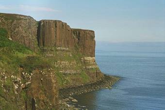
Kilt Rock, Isle of Skye exhibiting columnar jointing:
© Pam Brophy
|
The separation continues today through sea-floor spreading along the mid-Atlantic Ridge which passes through Iceland. It is interesting to ponder why the new plate boundary tore into the old continental mass – which geologists call a ‘craton’. One explanation is that the continental plate had been weakened by a ‘plume’ – an upwelling of hot mantle rocks from deep below, rather like a lava lamp. It is thought that one such plume underlies Iceland, because a plume gives rise to oceanic crust that is unusually thick – just what you see in Iceland, and the explanation of why it rises above sea level. So – long ago, when the splitting was beginning, were there precursors to this ‘extra’ magmatism now forming Iceland?
Yes! The North Atlantic is rimmed by igneous rocks of early Tertiary age (60-55 million years old) – they are collectively known as the North Atlantic Igneous Province. Western Scotland and northern Ireland have the roots of ancient volcanoes, extensive flood basalt flows, and regional vertical intrusions (dyke swarms). Dykes are sheet-like, near vertical bodies of once molten rock (usually basalt) which form when rocks are cracked by stretching, opening up fissures which are filled from below.
The most extensive site where you can see these is on the Isle of Skye. The northern part of the island is dominated by horizontal/sub-horizontal basalt lava flows, which give the landscape a characteristic ‘table-land’ morphology. Punching through these are the volcanic centres – the roots of ancient volcanoes. The most famous of these form the rugged peaks of the Cuillins.
These hills are made up of layered sheets of gabbro (a coarsely crystalline equivalent of basalt, which cooled more slowly deep in the Earth), stacked rather like nested, upside down plastic cups. The Cuillin gabbros are cut by granites of the Western Red Hills. Other granites form the Eastern Red Hills. Granites are coarsely crystalline like Gabbro, but are lighter in colour because they contain more quartz. Some of these granites formed by a process of chemical evolution called ‘fractionation’. As magma crystallizes, different components crystallize out at different times, leaving behind a melt that becomes progressively rich in silica, which forms quartz when it cools.
|
|
Dyke on Elgol: © Rob Butler
|
|
Other granites form the other way around - by partial melting of the deeper continental crust, heated up by the intrusion of very hot basic magma from the mantle. The granite in effect is like the more volatile component that gets driven off. Geochemical studies of the Skye granites indicate that both of these processes have occurred – illustrating the complexity of igneous processes that can happen as continents split apart.
Direct evidence of the splitting process comes from the dykes, which are direct evidence of a tensional regime that lasted for many millions of years. Dykes are found throughout Skye, intruding the older bedrock. Great examples are found on the coast at Elgol where basaltic dykes cross-cut Jurassic strata. Rather fewer dykes are seen to cross-cut the gabbros of the Cuillins and fewer still cut the granites. These relationships indicate that dyke intrusion happened over a very long period - throughout the igneous history, for which reason fewer dykes cross-cut the later (younger) intrusions.
Further reading:
Emeleus, C.H. & Gyopari, M.C., (1992), British Tertiary Volcanic Province, Geological Conservation Review Series, No. 4, Chapman and Hall, London, pp. 259. ISBN 0 41247 980 7
Twinned with: Mount Kilimanjaro, Tanzania
Mount Kilimanjaro, in northern Tanzania, is the largest of 20 volcanoes located near the eastern flank of the southern end of the East African Rift Valley (EAR).
The EAR is part of a ‘Y’ shaped active continental rift system where the continental lithosphere is being stretched and thinned to form two new plates; the Nubian and the Somalian plate. The rifting on the EAR began in the Miocene around ...continue reading