Geological sections, 1817-1819
|
|
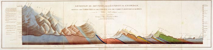
'Geological section from London to Snowdon, showing the Varieties of the Strata, and the correct altitude of the Hills', published by John Cary, 15 July 1817.
|
|
|
|
|
| Section from Smith's 1815 Map |
|
In general terms, William Smith’s 1815 Map can be interpreted as looking at the geology of the British Isles from above. Between 1817 and 1819, Smith issued six sections showing what England and Wales looked like underneath the surface. The first was the impressive 1.3 metre long 'Geological Section from London to Snowdon showing the Varieties of the Strata, and the correct altitude of the Hills’ (1817) and is a more sophisticated version of the simple diagrammatical section which appeared in the 1815 geological Map.
The sections are a further extension and explanation of Smith’s stratigraphical theories and, like his other publications after 1815, refer back to his geological Map including the use of corresponding colours to delineate the strata. Indeed these sections and the following county maps share the same publisher, John Cary.
|
|
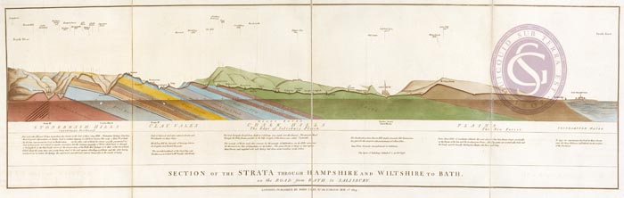
'Section of the Strata through Hampshire and Wiltshire to Bath, on the road from Bath to Salisbury', published by John Cary, 1 May 1819.
|
What the sections demonstrate is how Smith saw the stratification of rocks. He believed that most stratigraphy was inclined and the protruding edges or outcrops of each were what he primarily delineated on his maps.
The other sections can be seen on our Picture Library.
|
<<Aftermath of the Map
'New Geological Atlas of England and Wales'>>