North Pennines, England
 Spectacular Scenery
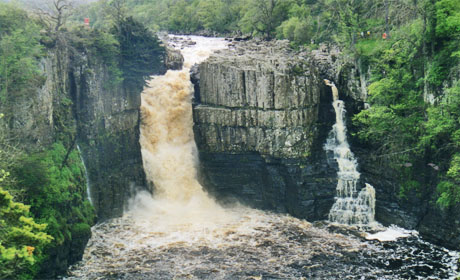
Upper Teesdale is a Site of Special Scientific Interest which has a number of nationally rare habitats linked to the geological diversity. There are several sites of national geological importance such as the Whin Sill exposures at High Force and High Cup Nick, along with many metalliferous mining sites.
Geology
The oldest rocks are those of the Ordovician period, formed between 495 and 443 million years ago. Ordovician rocks crop out only in a very restricted area, known as the Teesdale Inlier, beneath Cronkley Fell in Upper Teesdale. These are part of the Skiddaw Group, mainly slates and the Borrowdale Volcanics.
Carboniferous rocks form the majority of the area and these were formed between 350-320 million years ago when the area was submerged beneath a wide, shallow tropical sea, in clear, warm waters and beds of limestone accumulated. Influxes of sand and mud give rise to the cycles of deposition typical of the area with a repeating sequence of limestone, mudstone, sandstone.
Deposition was influenced by the underlying Weardale Granite (Devonian) which provided a buoyant basement which prevented the area subsiding. As a result a much thinner succession of Carboniferous limestones, mudstones and sandstones accumulated on this ‘block’ than in the adjoining areas. This area is known as the ‘Alston Block’.
The Great Whin Sill
Towards the end of Carboniferous times, about 295 million years ago, continuing stretching of the earth’s crust allowed the up-welling of huge volumes of molten rock from deep within the earth. This magma did not reach the surface, but spread out as sheets and layers between the existing Carboniferous rocks. As it cooled and crystallised to form the dolerite of the suite of intrusive rocks collectively known as the Whin Sill, its heat altered many of the adjoining rocks, turning limestone into marble, known in Teesdale as the ‘Sugar Limestone’ and shales into ‘hornfels’, or as it is known locally, ‘whetstone’.
Columnar joining is conspicuous in most exposures. The sill reaches its maximum known thickness of around 70 metres in Teesdale. Radiometric dating reveals an age of around 295 million years for the Whin Sill. Palaeomagnetic studies reveal that at the time of its crystallisation the area lay within tropical latitudes. It can be seen at High Force waterfall and in quarries on either side of the valley.
Shortly after the formation of the Whin Sill, mineral rich waters, warmed by heat from the Weardale Granite, began to circulate through cracks and faults in the rocks deep within the earth’s crust. As they cooled, their dissolved minerals crystallised forming the veins and associated deposits of the North Pennine Orefield. Metalliferous mining, along with glaciation, has shaped the landscape we see today with evidence of working by surface methods such as ‘hushes’ and underground. Mine spoil heaps add to the biodiversity of the area.
Text courtesy of Lesley Dunlop