Sam Cornish, supported by the Society’s Annie Greenly Fund, has been unravelling subduction and exhumation in NE Oman
 Oman is a country of exceptional natural beauty, and the geological story behind its landscape only adds to the wonder. Jagged, low mountains that surround the port cities of Muscat and Muttrah are made from rocks that once were part of the Earth’s mantle. In the enormous Jebel Akhdar dome, the same thick shelf carbonate sequence which forms the reservoir rock for much of Arabia’s oil wealth, arcs over 2000m high. Glittering green and black pods along the As Sifah coastline were subducted to depths of 80-100km before returning to the upper crust. Through the geological lens, such natural curiosities gain new significance.
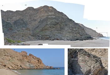
Image, right: Photographs showing the mafic eclogite boudin, enveloped by calc-schists on As Sifah beach
Ophiolite
About 95 million years (Myr) ago, newly formed Tethyan oceanic crust began to be thrust onto the Arabian continental margin in Oman. As the ophiolite was emplaced, the leading edge of the continental margin was dragged down a NE-dipping subduction zone, to depths of up to 80-100km. By 80Myr ago, the greatest depths recorded by rocks now at surface had been achieved. It is thought that at around this time a deeper part of the down-going slab broke off, allowing the positively buoyant continental crust to begin to return to the surface1.
 Oman has not yet collided with Asia (as Iran and India have), so it still displays a pristine geological record of continental subduction and ophiolite emplacement. Indeed, nowhere else in the world are the products of these processes so well exhibited, making it a tantalising destination for geologists interested in such events. (The weather, people and landscape undoubtedly add to the appeal!)
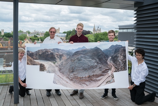
Image, left: Large inkjet print showing the northern end of the gorge, demonstrating the high-resolution of the panoramic images. Printed by Fotospeed
The aim of the game in my project, which benefited from a Geological Society field research grant, is to unravel the physical processes of continental subduction and exhumation (the latter meaning uplift of rocks relative to surface) through a careful study of the deformation experienced in the continental margin. This comprises work from the macro- to micro-scales; from resolving the structure of 25km of deformed margin, down to microstructural and electron backscatter diffraction studies.
Fieldwork
Fieldwork was carried out over two weeks in December 2015, a time of year when you can step outside without fear of melting under the sun like butter. I undertook the fieldwork with my supervisor, Mike Searle, who did his PhD on the emplacement of Oman’s ophiolite in 1980 and has been back to untangle its geological puzzles many times since.
 We worked in an area southeast of Muscat, capturing all the major structural units in the study area: from eclogite at the base in As Sifah, upwards across shear zones in As Sheik and from Yenkit to Ruwi, into carpholite-grade limestones and schists along Wadi Mayh, to the ophiolite and its unconformable Cenozoic carbonate cover at the coast.
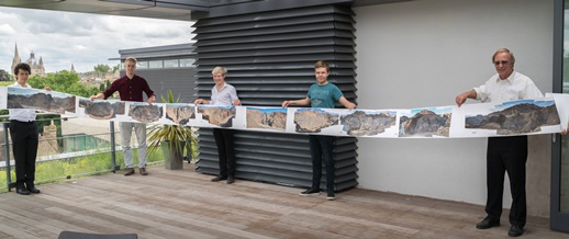
Image, right: A fold out book was made to display all 10 structurally interpreted panoramas. Kindly modelled by Sam’s friends and supervisor, Mike Searle (right).
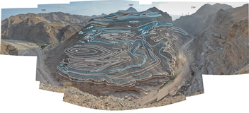
A particularly important part of the project is the Wadi Mayh mega-sheath fold2; a package of sheath folds stacked atop and beside one another, spectacularly exposed in the sheer-sided Wadi Mayh gorge. These folds are distinctively three-dimensional. Individual sheaths show isoclinal folds hundreds of metres long in the NNE-SSW section, and beds that wrap right around into rugby ball shapes in perpendicular section.
As well as shortening from both NNE-SSW and ESE-WNW directions, one sees signs of flattening: boudins with ‘chocolate tablet’ shapes are present both in the limbs of sheath folds and in flat lying shear zones. Altogether this presents a real geometrical puzzle, both to resolve the current structure and to model the multistage process of formation. The limestone appears rock-solid today at surface, but its deformation patterns imply mechanical properties more like soft lasagne. A rheological perspective, informed by the microstructure and the predicted temperature and pressure history, is paramount when reconciling these two disparate impressions.
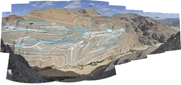
 Image, left: Panorama with structural interpretation overlain. White lines and blue lines show where bedding planes and shear planes, respectively, intersect the surface. Note how beds wrap into rugby ball shaped exposures, boudins are found along shears, how the competent limb on the right hand side sweeps around the sheath. This panorama is centred on a direction slightly oblique to the principal transport direction (which is NNE-SSW). The extent, magnitude and complexity of deformation in the continental margin is striking. Deformation is distributed throughout the study area; metre-scale tight to isoclinal folds are commonly found throughout rock that from a distance appears undisturbed. Deformation is most focused, however, on several major shear zones, across which metamorphic grade increases structurally down-section.
The story goes that activity on these NE-dipping shear zones was initially top-to-SW thrusting, associated with the subduction of the continent beneath oceanic crust, followed by bottom-to-SW shearing accompanying the exhumation from depth of the buoyant continental rocks, along the same subduction channel (though debate continues1,3,4). I am using microstructural relationships in shear zone samples to distinguish phases of deformation, and temperatures of deformation as recorded by crystallographic indicators in quartz to constrain the evolution of these shear zones.
Mangle
 The incredible complexity of the deformation becomes believable in light of the tectonic setting – a jammed subduction zone in which rocks were really put through the mangle.
Image, right: Panorama with structural interpretation overlain. This panorama looks at the western side of the gorge. Parity with the structures in the WM5 panorama can be seen.
Any hope of progress in such a complicated structural setting requires detailed, testable data. Unfortunately, traditional methods of structural mapping require trust in the observer’s interpretation; it is hard to test a field sketch without seeing the outcrop for yourself.
With the advent of high quality digital photography, however, it is now possible to collect rigorous data against which to evaluate structural interpretations. When mapping along cliffs, gorges and mountainsides with near perfect exposure, the photographic method allows excellent documentation of geological structure.
My technique was to take a series of panoramic photo-merges along sections of interest. In total, I made over 100 photo-merges and did two drone surveys. I am currently resolving the structure in individual images, and will progress to resolving the entire section. Care must be taken regarding perspective and in visualising the planar geometry of beds and shears. In the Wadi Mayh sheath fold area photographic coverage was dense enough to allow construction of a three-dimensional model from the collection of images, using stereo-photogrammetry software (Agisoft Photoscan). This software works on the principle that multiple images of the same object, taken from different perspectives, can be combined by matching up common features into a 3D model.
Day in the life
 A typical field day begins in a tent on As Sifah beach, when the coming dawn rouses the sleeping geologist. Coffee. Staring blearily at the sun, rising above the ocean horizon. It is already hot, and the flies are up, too. Go easy on the gas when leaving the beach for a day’s work, or spend the rest of the morning digging the car out.
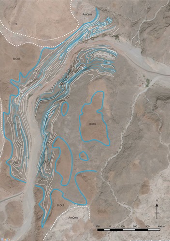
Image, left: Map showing the basic structure as determined using the panoramas
The days are hot, but manageable. A lunchtime dip when working on the coastal eclogite exposures is just the ticket and a good opportunity to check out the marine biology. Roadside geologising invites the friendly horn honks and waves of passing locals, while up high there are only goats for company. The views are spectacular; warm sunlight illuminates the canyons and mountainsides.
Returning to the beach, an after-dark swim among bioluminescent phytoplankton brings the day to a magical end. My swimming agitates them, sending green sparks of light off into the water. Can anyone doubt that geology PhD projects are the best?
Much has already been established about the tectonic history of NE Oman’s continental margin. Pressure and temperature studies, geochronology and biostratigraphy, large-scale mapping5 and structural studies combine to give a workable picture of the tectonic evolution6.
However, previous studies have not assessed the style and magnitude of deformation throughout key areas in a sufficiently precise or rigorous manner. This is a fundamental piece of the overall puzzle, taking us from coarse block-type models to a more ‘continuum’ understanding, connecting large-scale ideas of stress and strain to actual rock behaviour.
Acknowledgments
My thanks go to The Geological Society for financial assistance through the Annie Greenly fund. I also thank my supervisors: Mike Searle, for knowledge and company in the field; and Lars Hansen, for lab-based expertise. Thanks also to local drone pilot Mohamed Alnamani for giving up his time to help us produce drone surveys in Wadi Mayh and As Sifah.
For more information on how to apply for a Geological Society Fieldwork Grant, visit Awards Grants and Bursaries.
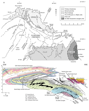
Image, below right: Simplified geological map and cross-section of NE Oman. Modified from Searle et al. 2004 fig. 3
 References
- Searle, M P, C J Warren, D J Waters, and R R Parrish (2004), Structural evolution, metamorphism and restoration of the Arabian continental margin, Saih Hatat region, Oman Mountains, J. Struct. Geol., 26, 451–473, doi:10.1016/j.jsg. 2003.08.005.
- Searle, M P, and G I Alsop (2007), Eye‐to‐eye with a mega‐sheath fold: A case study from Wadi Mayh, northern Oman Mountains, Geology, 35, 1043–1046, doi:10.1130/G23884A.1.
- Breton, J‐P, F Béchennec, J Le Métour, L Moen‐Maurel, and P Razin (2004), Eoalpine (Cretaceous) evolution of the Oman Tethyan continental margin: Insights from a structural field study in Jabal Akhdar (Oman Mountains), GeoArabia, 9, 1–18.
- Gray, D R, and R T Gregory (2003), Ophiolite obduction and the Samail ophiolite: The behaviour of the underlying margin, in Ophiolites and Earth History, edited by Y. Dilek and P T Robinson, Geol. Soc. Spec. Publ., 218, 449–466.
- Le Métour, J, de Gramont, X, Villey, M, 1986. Geological map of Masqat and Quryat and accompanying notes. Scale 1:100,000, Ministry of Petroleum and Minerals, Sultanate of Oman.
- Agard, P, M P Searle, G I Alsop, and B Dubacq (2010), Crustal stacking and expulsion tectonics during continental subduction: P‐T deformation constraints from Oman, Tectonics, 29, TC5018, doi:10.1029/2010TC002669.