New picture library, and Smith County maps
The Library has launched its own Picture Library, write Caroline Lam and Paul Johnson.
The Society Library’s new Picture Library, showcases some of the drawings, prints, maps and book illustrations to be found across its unique historical collection.
Here is one of the jewels to be found on our new site, www.geolsoc.org.uk/PictureLibrary . More images will be added regularly, so keep checking back to see what's new. All the images are available to purchase, including map prints.
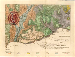 ‘Geological Map of the Environs of Lyme Regis’ published by F Dunster, 1826. [Image ref: 07-84]. Henry Thomas De la Beche (1796-1855) was raised in Lyme Regis which, thanks to Mary Anning, had become a popular fossil-hunting destination. This four-penny map, easily folded for the pocket, was published in Lyme and sold to those scouring the local rocks.
Smith county maps from the Publishing House
The Publishing House announces the availability of high-quality facsimiles of William Smith County maps, writes Emily Milroy
These may now be purchased directly from our Online Bookshop. With a choice of 20 counties, originally published between 1819 and 1824, each print is available individually on sheets of varying sizes approximately 53cm by 62cm. Order online, and a print can be shipped worldwide.