Product has been added to the basket

Testing Classical Enigmas

As geoscience edges closer to answering the riddle of “Strabo’s Channel” it may also solve one of the greatest mysteries in western literature, writes John Underhill*.


Geoscientist 18.9 September 2008


Editor's note: The web version of this feature does not contain all the figures present in the print version.  This is for a combination of space and technical reasons.  Omitted figures are indicated in the text and captions.  Captions are viewed by rolling your cursor over the figure.  This system does not allow lengthy captions, so some have been abbreviated. For full captions please refer to the print version. NB: this captioning function does not work if you are using Mozilla Firefox as your web browser.  For full functionality please switch to Internet Explorer.    Ted Nield

Figure 1: Islands of W. Greece. The disposition of modern Ithaki and its nearby islands and the Paliki peninsula (W. Kefalonia). Distances A and B, quoted by Strabo in stades, are converted to kilometres and compared with today’s measurements.

Figure 2: Aerial photograph of the Thinia isthmus on Kefalonia. The surface of the central area of the isthmus consists mainly of loose rockfall and landslide debris. Photograph by Robert Bittlestone.

The location of Homer’s enigmatic isle of Ithaca has puzzled scholars for over 2500 years. True, an Ionian island called Ithaki exists today off the western coast of Greece (Figure 1). But with a vertiginous coastline and high topography, facing east and standing nearest to the mainland of a group of three islands, it directly contradicts a key passage from the Odyssey describing Odysseus’ homeland as furthest out to sea of a group of four islands, low-lying and “facing the dusk” (i.e. west)1.


In 2003 Robert Bittlestone proposed a solution to this conundrum by suggesting that at the time of the Trojan War 3200 years ago, the low-lying western peninsula of Kefalonia (Paliki) had been an island. This idea demanded that a land bridge linking Paliki to the rest of Kefalonia had arisen since that time – posing a considerable geological challenge. Previous accounts of the project in which I and Cambridge University classicist James Diggle have been engaged were published in the book Odysseus Unbound2 and in Geoscientist3,4,5. The present article provides an update on progress since March 2007, when geoscience company Fugro agreed to sponsor the geological investigation using the latest land-based, marine and airborne technologies.

Figure 3: Geological surface survey of Thinia isthmus. The original two-dimensional survey diagram has been rendered by a digital elevation model (DEM).

Strabo’s Channel


In his 17-volume Geography, composed some time in the first two decades of the Christian era, the Greek writer Strabo described the known world, employing an astute combination of personal observation and other travellers’ reports. Describing Kefalonia he wrote:

Cephallenia lies opposite Acarnania, at a distance of about fifty stadia from Leucatas (some say forty), and about one hundred and eighty from Chelonatas. It has a perimeter of about three hundred stadia, is long, extending towards Eurus [east or south-east], and is mountainous. The largest mountain upon it is Aenus, whereon is the temple of Zeus Aenesius; and where the island is narrowest it forms an isthmus so low-lying that it is often submerged from sea to sea. Both Paleis and Crannii are on the gulf near the narrows6.

This 2000 year-old description contains some surprisingly precise and accurate measurements (Figure 1)7. These inspire confidence in the veracity of Strabo’s reference to a low-lying narrow isthmus near Paleis and Crannii that is often (but by implication, not always) covered by the sea from end to end. The location of these two settlements is not in doubt since they are still visible today. Strabo therefore provides independent reference to a marine channel in just the right place to make an island of the Paliki peninsula – a place now occupied by the isthmus of Thinia.

Figure 4: Satellite image of the Thinia isthmus, Kefalonia. Copyright: Google Earth/Digital Globe

So the notion of a buried marine channel that existed in the 13th Century BC is supported by a separate and much later historical reference, and is clearly testable using modern geoscientific methods. Over the past three years, field geology, geophysical techniques and geomorphic methods have therefore been deployed to test the theory.

Geological setting


The Thinia valley is approximately 6km long, up to 2km wide and rises to around 180m in its central saddle area (Figure 2). It is bounded on either side by steep hill ranges, rising to almost 1km on its eastern flank. Geological field studies show that Thinia may be separated into two distinct parts. The western area consists of a largely stratigraphically conformable but tilted, gently folded and locally thrusted (para-autochthonous) succession of Cretaceous and Paleogene limestones, unconformably overlain by Miocene marls and clastic sediments dipping gently eastward. In the eastern area, Cretaceous and Paleogene limestones dip very steeply westward (Figure 3)8. The boundary between the two provinces is the Aenos Thrust, which has emplaced the westerly-dipping Cretaceous-Paleogene limestones of the east onto the easterly-dipping Miocene sediments of the west (though its trace is largely obscured by rockfall debris).

The steep (45° - >60°) westerly dips seen on the east side of the valley are the result of their forming the western limb of a major hanging-wall anticline as a natural consequence of thrust emplacement. The eastern hillslopes along the Thinia valley are highly unstable and catastrophic collapse as a result of bedding-plane failure is common, with many of the steeply-dipping bedding planes showing evidence (e.g. slickensides) of down-dip (flexural) slip.

If Strabo’s account is accurate then as recently as 2200 years ago this isthmus, in places now 180m above sea level, was “often submerged from sea to sea”. The key questions are therefore:
  • What geological mechanism could have caused the infill?
  • What did Strabo mean by “often”?


Figure 5a: Mass wastage at Myrtos Bay. (Location: see Figure 4.). Photograph by John Underhill.

Tectonic instability


On a regional scale Kefalonia lies at the NW extremity of the Hellenic Subduction Zone, along which collision between Eurasia and Africa is taking place. Kefalonia is the most seismically active part of western Greece and is experiencing outer-arc uplift. Plio-Pleistocene sediments exhibit significant neotectonic deformation9.

The island is being thrust up by major earthquakes (M >7.0) occurring on average once every 50 years. On 12 August 1953 a magnitude 7.2 event uplifted much of the island by about 60cm, and there is growing evidence (from marine notches and raised beaches) of tectonic uplift of up to six metres having taken place (relative to sea level) over the last few thousand years. Although co-seismic upthrust is significant, the fact that the valley’s central saddle stands so high (Figure 2) clearly rules it out as a primary factor – but there are other factors at play.


Figure 5b: Deposits of mass wastage due to cliff failure, NE of Agia Kiriaki bay. (Location shown in Figure 4.). Photograph by Robert Bittlestone.

Slope failure


Triggered by powerful earthquakes, Thinia valley’s unstable eastern slopes often generate rock avalanches today and there is clear field evidence for major rockfalls and landslides in this area. Widespread boulder-strewn slopes are common, many involving high-volume mass wastage in which large sections of the mountainside have detached from underlying strata during the late Holocene.

Figure 4 is a satellite image of the isthmus in which the blue lines indicate unstable hillslope edges. Yellow and green lines show the most likely eastern and western boundaries for any buried channel, based on serial cross-sections, slope geometry and an extensive surface survey. The location of the narrow southern end of this potential channel route is closely constrained by the adjacent limestone strata, but the surface geology of the much wider northern segment at present suggests several possible channel routes for geoscientific evaluation.

Several spectacular examples of collapse characterise the coastline to the north of Thinia (Figures 5a & b). The photograph in 5a shows a large, unstable detached (olistolith) block on the eastern cliff of Myrtos Bay. The car highlighted for scale gives some idea of the mass involved. Figure 5b shows how contemporary cliff failure has narrowly avoided destroying the coast road. Much of the debris from this fall has already been washed out to sea here because the base of the cliff is unconfined.

The landscape on the eastern side of the Thinia valley consists mainly of loose, pulverised debris that has descended catastrophically from the mountains above. A major, isolated westerly-derived rockfall deposit also sits at the northerly end of the isthmus beneath the village of Zola. In several instances, extensive rockfall and landslide deposits have cut off roads and carried away houses (Figures 7 & 13).

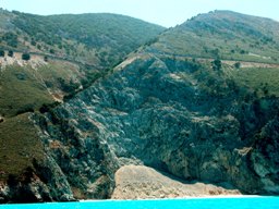
Figure 6a shows the scale of the eastern mountain range above Nifi village. As well as the effects of high-altitude co-seismic hillslope failure, this village also suffers from local landslides which can take place without help from earthquakes in wet conditions. The last such event occurred in November 2007 and destroyed several houses (Figure 6b & c). Further to the south of the island, the August 1953 earthquake triggered several major cliff collapses3.
Figure 6a: Gravitational potential for mass wastage at Nifi (Thinia valley). Photograph by Robert Bittlestone.

Geoscientific tests


Earlier land-based research work had focused upon geological mapping. The results highlighted the importance of rockfall debris strewn across large parts of the valley, particularly below its eastern slopes (from which most of the material evidently derived - Figure 3). However, it soon became clear that the existence of a buried marine channel could not be determined purely from surface geology, although field mapping alone has been relied upon in previous studies11,12,13. The only way of determining whether the Thinia rockfalls had infilled a former marine channel was to produce a 3-D view of the subsurface along the entire length of the Thinia valley. This demanded the drilling of a preliminary borehole and the use of geophysical methods and sampling to calibrate the subsurface data.

Figure 7 shows the location of a test drilling (October 2006)4. Although the borehole site was bordered on east and west by bedrock limestone, the surface material there consists of loose rockfall running north-south. The location sat 107m asl. and a 122m borehole was drilled (i.e. to 15m below today’s sea level) without encountering any solid limestone. 

Figure 6b: Catastrophic landslide at Nifi (Thinia valley), November 2007. Photograph by John Underhill. Significantly, the marine microfossil Emiliania huxleyi was found admixed with older, loose rockfall sediments within the top 40m of the drill hole. This single-celled phytoplankton (coccolithophore) could not have reached this location earlier than about 6000 years ago, when rising global sea levels penetrated the shallow Gulf of Livadi for the first time. So how did this recent microfossil become embedded within loose rockfall material 40m below today’s surface?

One explanation could involve the chaotic intermingling of a high-volume rockfall with the waters of a confined marine channel. Alternatively it could be that the wind-blown products of a marine bloom had already been deposited on the pre-rockfall surface and were subsequently incorporated into loose sediments during a rockfall. Whichever the explanation for its presence, it is clear that rockfalls have indeed buried a substantial ancient relief with sediments that must date from the late Holocene.

After drilling, gamma ray and resistivity were measured through well logging. These were compared to cutting samples and to onsite geomorphology. That integration enabled the relationship between the drill site and geology to be assessed accurately and a cross-section to be constructed showing the underlying strata at this location (Fig.8). The borehole drilled through 40m of rockfall material before encountering a Miocene marl boundary on the east of the diagnosed channel sidewall. 

Figure 6c: Newspaper report: “Nifi’s Night of Horror: sudden catastrophe drowns 4 houses in mud” In February 2007 the geotechnical, survey and geoscientific service company Fugro became the project’s principal sponsor, which includes a Natural Environment Research Council (NERC)/CASE-sponsored PhD studentship based in the School of Geosciences at The University of Edinburgh. The collaboration has brought in substantial land, sea and airborne resources. A successful field campaign during in the second half of 2007 has now generated much new, high-quality data.

Field teams from Fugro and Edinburgh University have conducted resistivity, seismic refraction and gravity surveys in key areas. The integration of these geophysical techniques has afforded excellent resolution of the buried bathymetric profile of an ancient lake bed, termed Lake Katochori, lying to the west of the proposed channel route (Figure 9). As a result it has become clear precisely where to drill shallow boreholes in order to obtain a core from which radiocarbon dating of the oldest sediment (i.e. from the deepest part) of the former lake can take place. If most of these sediments prove to be younger than c. 2200 years old, then this will support Strabo’s observations. If they are older, the hypothesis will have to be reconsidered.

Other gravity lines located across the eastern side of the valley have yielded some intriguing negative Bouguer anomalies. Although these seem consistent with the presence of a buried channel, there are currently insufficient data to make a rigorous assessment. In addition to a follow-up gravity survey planned for the eastern area and a shallow drilling programme in Lake Katochori and infilled coastal plain areas, the next land-based stage may involve acquiring seismic reflection data along and across the possible route of the buried marine channel. Subject to results, the intention would be to drill additional deep boreholes in the saddle of the valley, where the proposal is most severely challenged – namely at the narrowest boundaries and highest elevations. Radiocarbon dating of core samples from these locations is expected to provide a definitive assessment of the composition and age of the valley fill, down to sea level and below.

Figure 7: Diagnosed southern exit of Strabo’s Channel. Yellow, green lines - see Fig. 4. Red arrow - borehole drilled October 2006 at the southern limit of interruption (by rockfall and landslides) of a track that re-emerges 800m to the north.

 Fugro Airborne Surveys of Canada have performed an aerial electromagnetic survey of the Thinia valley using a multi-frequency transmitter/receiver attached via a cable to a helicopter and flown at low altitude over Thinia and northern Paliki (Figure 11 - omitted for space reasons. See print version), producing detailed maps of resistivity and magnetic susceptibility. Figure 12 maps near-surface ground resistivity measurements from this survey (which achieves a subsurface penetration of c.90m). Blue and dark green colours (resistive) correspond to limestone bedrock. Light green and yellow represent marl, conglomerate and loose rockfall. Orange and red represent conductive sea water or saline-saturated sediments. Uncoloured areas are villages that were not overflown. From this it is clear that the Thinia valley consists mainly of low resistivity material (i.e. marl, conglomerate and rockfall debris) down to at least 90 metres. However, because much of the central section of the valley stands higher than 90m asl, this is supportive rather than conclusive evidence as far as the theory is concerned.

Figure 8: Test Borehole. The upper image shows the borehole location relative to Figure 7 (print version only); the lower diagram indicates the underlying geology.

 Fugro has also used its FLIMAP laser tele-altimetry technique to highlight areas where slope failure has occurred - especially where this is not always obvious from ground survey alone. FLIMAP provides helicopter-based photographic mapping and laser terrain elevation measurement, and as a result the project has access to an unprecedented array of digital maps, elevation models and photographic imagery of the terrain, to an accuracy of a few centimetres. This supports field observations that catastrophic (probably co-seismic) failure of the western slopes has destroyed the walls of human settlements. Remnants of former habitation (including houses with tiled roofs) occur within landslides located downslope (Figure 13). Such dramatic evidence of hillslope collapse may enable us to assess not only the volume of mass wastage triggered, but also its approximate date, using cosmogenic isotope dating techniques.


We hope that Fugro NPA Limited’s field-based laser scanning (LIDAR) site surveys and satellite-borne Interferometric Synthetic Aperture Radar (INSAR) methods can be deployed as part of the project to quantify these slope movements, which could potentially also provide input for early warning of slope instability.

Figure 9d - the resulting resistivity map defining the sedimentary fill at Lake Katochori. Fugro’s Italian-based marine subsidiary Oceansismica has conducted a detailed survey of the coastal waters both south and north of the Thinia isthmus, using state-of-the-art high-resolution marine seismic reflection and side-scan sonar (Figure 14 - ommitted, technical reasons.  See print version). This has generated a large quantity of marine data, currently undergoing interpretation. It has thus become possible for the first time to investigate not only the buried Holocene sediments, but also their basal unconformity and the Hellenide (Alpine) structures affecting the bedrock (Figure 15).
High resolution analysis of the buried, sub-Holocene erosional surface (Figure 16b) has confirmed that the area of deepest marine bedrock is indeed aligned with the diagnosed southern exit of “Strabo’s Channel” (Figure 16a). The fidelity of the new data highlights the submarine structure and also the alignment between terrestrial and marine aspects of the supposed southern exit of the channel. Figure 16b shows how this coincides with the deepest area of the seabed - not only in the N-S direction at the channel mouth, but also with the diagonal submarine reef structures on either side (shown in red).

In other words, not only is there a U-shaped embayment in the submarine bedrock precisely at the channel’s supposed southern exit, but the diagonal direction of the bedrock reefs on each side also aligns exactly with the erosional fluvial outflow from the Thinia valley (dating from a time of lower global sea-level, when marine waters had not yet entered the bay).

Figure 10c: Gravity survey results (lmap) at Lake Katochori (for location see Figure 4).
Figure 12 Results of the resistivity survey of Thinia Isthmus and N. Paliki, based on a blend of all 5 frequencies with a penetration depth of 90m. Backgnd. image Copyright Google Earth/Digital Globe
Figure 12: Results of the helicopter-borne resistivity deployed over the Thinia isthmus and northern Paliki, based on a blend of all five frequencies acquired and providing a penetration depth of up to 90m below the surface. Permission Google Earth.

Conclusions


It is not yet possible to state categorically that Strabo’s description of the Thinia isthmus is confirmed by geoscience. However, the results to date show that his account remains feasible. The airborne electromagnetic survey, together with the precise alignment of the marine bedrock at the channel’s diagnosed southern exit, are thought-provoking and clearly deserve further investigation.

The massive scale of slope failure, rockfalls and landslides in the Thinia valley provides a plausible explanation of why Strabo described this channel as ‘often’ rather than ‘always’ submerged from sea to sea, since any channel at this location would have been periodically interrupted by debris - both by rockfalls and by the erosion of the soft Miocene marl on its western side.

The hypothesis would be refuted, however, if a buried land bridge of limestone bedrock were encountered above sea level in a future critical borehole. The research priorities now are therefore to core and date samples from sediments in the ancient Lake Katochori, which onlaps onto rockfall debris; to conduct more comprehensive gravity and seismic reflection surveys of the diagnosed channel route, and (subject to these results) to drill one or more deep boreholes to below sea level from which core samples can be extracted and dated.
Figure 13: Closeup shows part of a building constructed on a limestone block transported downslope as rockfall. Photograph by John Underhill.

Acknowledgements


I would like to express my thanks to all those who have made the current research possible and who are facilitating the next steps: IGME (Institute of Geology and Mineral Exploration), Athens; Ministry of Foreign Affairs, Athens; Ministry of Culture, Athens and Kefalonia; Fugro NV, Netherlands; NERC (Natural Environment Research Council), London; Dimarcheion of Paliki, Kefalonia; Dimarcheion of Argostoli, Kefalonia; colleagues at the Bulgarian Academy of Sciences; colleagues at the University of Edinburgh; and my collaborators at Odysseus Unbound, Robert Bittlestone and James Diggle. Kirsten Hunter, Greg Hodges and David Kilcoyne are acknowledged for their help in constructing Figures 9, 10 & 12.

Forthcoming lecture & further information


John Underhill will present the latest results of this research at the Geological Society, Burlington House on 2 October 2008 as part of the Shell London Lecture Series. Details of this event and other news about the Odysseus Unbound project are provided at www.odysseus-unbound.org

Figure 15: Seismic reflection line, Livadi Bay. Note buried, base-Holocene unconformity and previously undocumented, highly deformed (folded, thrust and erosionally truncated) Neogene strata beneath. Location - Fig 16a.


References


  1. Homer, Odyssey 9.19-26, interpreted by James Diggle at www.odysseus-unbound.org/discovery.html
  2. Bittlestone, R., Diggle J., Underhill J.R. 2005. Odysseus Unbound: The Search for Homer’s Ithaca. Cambridge University Press.
  3. Underhill, J. R. 2006. Quest for Ithaca. Geoscientist, 16 (9). pp. 4-29. ISSN 0961-5628.
  4. Nield, T. 2007. Ithaca theory gains support. Geoscientist, 17 (2). pp. 8-10. ISSN 0961-5628.
  5. Nield, T. 2007. Fair wind for Odysseus. Geoscientist, 17 (4). p. 11. ISSN 0961-5628.
  6. Jones, H. L. 1917–32. Strabo: Geography. Loeb Classical Library (Harvard University Press), Cambridge, Mass. 10.2.15.
  7. Bittlestone et al. op.cit. pp. 51-52.
  8. This account of Thinia is a brief summary drawn from my description in Geoscientist 16 (9) above.
  9. Underhill, J. R. 1989. Late Cenozoic Deformation of the Hellenide Foreland, Western Greece. Geological Society of America Bulletin 101, 613–34.
  10. Hewitt K., Clague J., Orwin J. 2008. Legacies of catastrophic rock slope failures in mountain landscapes. Earth-Science Reviews 87 p. 33.
  11. Riemann, O. 1879. Recherches archéologiques sur les Iles Ioniennes: ii Céphalonie. Thorin, Paris. p. 9: “This last suggestion seems quite extraordinary: there is not a single place on the island where this could be true: the isthmus that Strabo apparently describes would be that of Agia Kiriaki which joins the peninsula of Paliki to the main bulk of the island; but this isthmus is more than 500 feet above sea level” (translated from French and quoted in Bittlestone et al. op.cit. p. 380).
  12. le Noan, G. 2001. A la recherche d’Ithaque. Editions Tremen, Quincy-sous-Sénart. In chapter 10 the author provides an opinion from geologist D. Sorel that “Strabo’s description of a partially submerged isthmus appears impossible wherever on Paliki one attempts to locate it” (translated from French and quoted in Bittlestone et al. op.cit. p. 382).
  13. Maroukian H., Gaki-Papanastassiou K., Papanastassiou D., Karymbalis E. 2006. The Geomorphological-Palaeogeographical evolution of N.W. Kefalonia with special reference to the area between the Gulf of Argostoli and the Harbour of Hagia Kyriake in the Upper Holocene Period. Faculty of Geology, University of Athens, unpublished paper (in Greek) for the Association of Ithakans Worldwide.

* Grant Institute of Earth Science, School of Geosciences, University of Edinburgh, The King’s Buildings, West Mains Road, Edinburgh, EH9 3JW, UK ([email protected]).

Figures 16a, b: Maps depicting the depth to the Base Holocene in the Gulf of Livadi. These show the consistency of outcome between (a) the previous regional survey and (b) Fugro Oceansismica's recent high-resolution survey. Red line - fig 15