Product has been added to the basket

The great divide

1. Aerial photograph of Lyme Regis showing the central area of landslipping. The Cobb, Lyme’s ancient harbour, is seen to the west. Copyright permissions, West Dorset District Council.The Lucy’s Ledge Fault at Lyme Regis divides the famous resort in two - landslipping to the west and stable ground to the east. Geoff Davis* and Bruce Menzies# explain how detailed geological understanding now literally underpins its recent remediation.


Geoscientst 20.10 October 2010

“The Earth here has a tendency to slide into the sea, and so its parasites desired to keep it above water.”

F J Harvey Darton, “The Marches of Wessex” (1922)


Landslipping at Lyme Regis, Dorset, on the south coast of England, has caused structural damage to property for hundreds of years. Its effects are therefore so ingrained in the town’s built heritage that even the most un-geological of its many admirers over the centuries seem to have been as conscious of the underlying geological unease as of the more obvious threat posed by the sea.

The great surgeon Sir Frederick Treves (1853-1923, remembered today for the part he played in rescuing “Elephant Man” Joseph Merrick from the freak shows of London) wrote in his 1914 Highways and Byways of Dorset that Lyme’s houses “like the Gadarene Swine, appear to be running down a steep place into the sea...and are only prevented from tumbling into the ocean by a sudden sea wall, over which they hang, unsteadily”. While prolific editor Arthur Mee (1875-1943), in his Dorset guidebook (King’s England series, 1939) thought that “the hills seem to be tipping the houses into the sea”.

This, of course, is much more than mere semblance. Yet curiously, when superimposed onto a map of the town, a plot of damaged properties from recent times shows that this damage is concentrated to the west of the town - with little or none occurring immediately to the east.


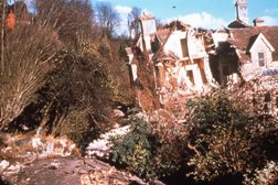
A not uncommon site in Lyme Regis

In the teeth of the gale


Lyme Regis, sitting astride the mouth of the River Buddle (or Lym) on an actively receding stretch of West Dorset coastline, has always faced considerable challenges from the twin threats of landslipping and erosion.
The earliest geotechnical projects undertaken at Lyme were designed to protect it from destruction by the sea.

First mentioned in the Domesday Book (1086), the town received its Royal Charter (adding the “Regis” to its name) in 1284, and during the 13th Century it developed into the major trading port and shipbuilding centre of Lyme Bay. Later, it became a fashionable resort, a kind of Bath-on-Sea, exemplified by the quaintly named “Ozone Terrace” - recalling a time when ground-level ozone was considered to be a good thing. The town soon developed a strong literary, artistic and scientific following. Jane Austen began the trend, with her final (and posthumously published) novel Persuasion, whose character Louisa Musgrove comes a nasty cropper on some treacherous steps - the so-called Granny’s Teeth – which stick out like corbels from Lyme’s most notable piece of geotechnical engineering, its curving 265m (870 ft) breakwater and harbour wall, known as The Cobb.

Austen’s book brought literary pilgrims throughout the 19th Century (Tennyson, visiting Lyme resident Francis Palgrave - of Golden Treasury fame - is said to have demanded to see the site of Miss Musgrove’s tumble immediately upon arrival), and it was this early tourist trade that allowed Lyme’s most famous daughter, Mary Anning, to earn a meagre living. Many of the well-to-do visitors (including Buckland and Conybeare) came to pursue their interest in the hottest scientific topic of the age – geology - and so enabled Mary to turn her fossil-finding talents to good commercial use.


The newly extended Cobb The Cobb, Britain’s oldest significant coast-protection system still in operation, was first constructed in the 13th Century by Edward I, though the present structure was largely built in 1825 when (as Treves wrote): “it rose afresh from the ruin wrought by the memorable gale of the previous year”. In the 20th Century, the Cobb received fresh publicity when it co-starred with Meryl Streep and Jeremy Irons in the film of The French Lieutenant’s Woman by John Fowles (who worked as curator of the town’s Philpot Museum from 1979 to 1988). The film’s most striking image, of Miss Streep standing on The Cobb in a hooded cape above a storm-tossed sea, clearly epitomised the town’s vulnerability to southwesterly gales.

The town’s other sea defences are considerably more recent. Not until around 1860 was Lyme’s principal sea wall (along the town’s frontage) successfully completed, while the wall on its eastern flank was built as recently as the 1950s. The sharp recession of the coast at the end of this wall (see aerial photograph) illustrates that, were it not for such defences, the part of the coast occupied by Lyme would also have retreated at the same rate (estimated at about half a metre per year). There is strong historical evidence that a large part of original mediaeval Lyme has been lost to the sea1; in effect, the port of Lyme now stands on a promontory entirely of its own making.


Beach replenishment using shingle from the Isle of Wight and sand from France - all brought by barge

Landslipping


In our own times, as the value of property and the wealth of those occupying it have risen, geotechnical emphasis has broadened away from coastal reinforcement to address the more insidious threat of land slippage. Such problems have been particularly serious during the 20th Century, when some 15 individual properties were destroyed and many more severely damaged. This situation was unlikely to improve unless some action were taken, as the climate in West Dorset appears to be getting wetter - every year of the decade since 1993 having been wetter than the long-term average (1868-2002). Several major sea-wall breaches have also occurred along the main frontage, as well as frequent substantial damage to Cobb Road and the complete loss of the main coastal road east to Charmouth. As a result, a major programme of ground stabilisation and coastal management was commissioned, implemented and recently completed, by West Dorset District Council (WDDC).

Ground conditions at Lyme Regis comprise a sequence of interbedded mudstones and layers of limestone within two Lower Jurassic units – the Blue Lias Formation below and Charmouth mudstone Formation above – and atop them, the Upper Greensand and Gault Formations of the unconformable Lower Cretaceous cover. Landslide deposits, consisting of largely cohesive materials of variable thickness, mantle the in situ geology. The diagram shows a typical ground model section based on observations3. Groundwater levels within the landslide materials lie close to ground surface, while pore pressures recorded within the in situ geology suggest under-drainage.


Slopes and new sea wall were stabilised using 110 bored piles reinforced by steel tubes - and in some cases beams, and also using steel tube soil nails Coast protection and slope stabilisation works began in 2005 and were finished in 2007. These measures comprised a combination of slope drainage, slope strengthening (including bored piles and reinforced earth berms), the provision of new jetties to retain the beach, the realignment and extension of existing breakwaters, strengthening and refurbishment of existing seawalls, and beach replenishment4. However before the stabilisation works could begin, it was necessary to understand the curious asymmetry of the landslip pattern across Lyme Regis.

The Lucy’s Ledge Fault


As we have seen, when the WDDC plotted the locations of substantial landslipping and other movements in the 20th Century onto a map of Lyme Regis1, it became evident that the damaging earth movements covering the period 1902 - 2000 were clearly concentrated to the west of the town. No such movements occurred to the immediate east during this period.


Sub-horizontal drilled drainage arrays were used to empty vertical joines of groundwater. The WDDC and their consultants also produced a detailed geological map of Lyme Regis1,2, which shows the existence of several geological faults passing under the town. These generally have small throws; but crucially, the dip of the strata often changes across them. One such fault clearly coincides with the observed boundary between the unstable ground to the west and the relatively stable ground to the east, revealed by the plot of landslip data. This is the so-called “Lucy’s Ledge Fault”1, named for a prominent limestone outcrop exposed during low tide on the Lyme Regis foreshore. On the geological map, the Lucy’s Ledge Fault can be seen to run perpendicularly to the shoreline, cutting through (or near) the old garage in the car park behind the landmark Three Cups Hotel – which has stood on the same site since the 17th Century (though the current building dates from the 19th Century) and played host to such luminaries as Jane Austen, Jimmy Cagney, Charlie Chaplin, General Eisenhower as well as Longfellow, Chesterton and Tolkien.


Typical ground model section at Lyme Regis, after Fort et al. (2000).
Vertical trench drains were placed normal to the sea. Garden slopes were reformed into berms using reinforced earth and geomembranes The main agency driving landslips west of the Lucy’s Ledge Fault is the dip of the ground strata downwards towards the beach. This is in fact the same process that drives landslipping all along this stretch of coast, where units of varying permeability dip seaward at different angles (Geoscientist 19.12, p. 5). The ground thus slides downslope and down-dip towards the shore, propelled by a combination of gravity and hydraulic forces generated by ground water in joints separating the moving blocks sliding along detachment planes where more permeable strata above meet less permeable ones below.

Clearly, the degree of seaward dip is crucial in regulating this process, and the clue to the Lyme Regis’s “great divide” lies in the small changes in dip that occur across these minor faults. Beneath the westerly zone of active and damaging landslipping, the strata dip seawards at 5.4°. To the east of the Lucy’s Ledge Fault, however, the seaward dip is only about 3.2°. This difference of 2.2° is enough to create essentially stable ground conditions east of the fault.


3. Map of Lyme Regis town showing incidence of substantial landslipping and geological faults - including Lucy’s Ledge Fault. Data abstracted from 1. © West Dorset District Council and High Point Rendel. Reproduced with permission.
The outcrop known as Lucy’s Ledge is formed by a relatively resistant limestone layer; one which has played a crucial role in the WDDC plan for stabilising landslips in Lyme. A major part of the plan has involved strengthening the slope using 1150 bored piles and rock nails to socket the unstable landslide units into stable strata below - the limestone forming Lucy’s Ledge being one such unit. In determining the position and depth of piling, detailed knowledge of the underlying geology and groundwater regime has been crucial, because the subsurface depths of each of the landslide-controlling units has had to be determined to within a few hundreds of millimetres in critical areas, to ensure that piles or drains are constructed deeply enough to penetrate the landslide shear surface and provide the slide with sufficient restraint. Thus, the precise whereabouts of small faults, even those with fairly negligible throws, was critical – since any local change in the elevation of a particular crucial horizon could severely compromise the effectiveness of the stablilising measure.

Thanks to such detailed knowledge of geology – a subject in whose history Lyme Regis enjoys almost legendary status – the land stabilisation measures, coastal defence improvements and public amenity works carried out by WDDC should ensure that residents and visitors alike continue to enjoy this jewel of the “Jurassic Coast” in safety and security for many decades to come.


References

  1. West Dorset District Council 2000: Lyme Regis Environmental Improvements. Preliminary Studies. Summary Report, Report 14/1, August 2000, WDDC.
  2. Gallois R W and Davis G M 2001: Saving Lyme Regis from the sea: recent geological investigations at Lyme Regis., Dorset. Geoscience in South West England 10, pp 183-189.
  3. Fort, D S, Clark, A R, Savage, D T and Davis, G M 2000: Instrumentation and monitoring of the coastal landslides at Lyme Regis, Dorset, UK. Proc. 8th International Symposium on Landslides, Cardiff. Thomas Telford Publishing, London, pp 573-578.
  4. Fort D S, Martin, P , Clark, A R and Davis G M 2007: Lyme Regis Phase II coast protection and slope stabilisation scheme, Dorset, UK - the influence of climate change on design. In: Landslides and Climate Change by McInnes, Jakeways, Fairbank and Mathie (eds) pp 419-428.

Suggested further reading

  • Brunsden, D, 2002: Geomorphological roulette for engineers and planners: some insights into an old game. Quart. Jour. Eng. Geol. & Hydrogeol., 35, 101-142 (Glossop Award address by doyen of engineering geomorphologists Denys Brunsden, a resident of West Dorset.)

Acknowledgements


We gratefully acknowledge copyright permissions from West Dorset District Council and High Point Rendel to abstract data from maps contained in the Summary Report (WDDC, 2000), specifically from the following: Map 1. Location of substantial landslipping and other movements in the 20th Century (Drg No. LRE122J\609). Map 2. Geological map of Lyme Regis (Drg No. H431/P/CG-H/9.3.1 June 1998). Much of the mapping of the Lyme Regis foreshore was carried out by Dr R W Gallois. We also acknowledge permission from West Dorset District Council to reproduce the aerial photograph of Lyme Regis.

Authors


*Geoff Davis is an engineering geologist with a particular interest in the assessment and management of coastal instability and erosion. A large part of Geoff's recent experience was gained with West Dorset District Council as team leader for the Lyme Regis Coast Protection Scheme. Most recently, Geoff has worked on a variety of projects including investigation and risk assessment for landslides and coastal erosion in the UK, and the assessment of offshore geohazards on the Nile Delta. He has published 12 papers on aspects of landslide management, site investigation and public relations.

#Dr Bruce Menzies is the founding President of Global Digital Systems Ltd (GDS –www.gdsinstruments.com). He is co-author of five books on geotechnical engineering including one on slope engineering (including a section on remedial measures at Lyme Regis). He has co-authored a book on geology for civil engineers. The books are listed below. He was Visiting Scholar at the Hong Kong University of Science and Technology in 2003. He holds doctorates from the universities of Auckland and London, is a Chartered Engineer, a Fellow of the Institution of Civil Engineers, a joint winner of the British Geotechnical Association Prize 2002.

Geotechnical Engineering and Geology books co-authored by Bruce Menzies

  • Simons, N.E. and Menzies, B.K. (2000) A short course in foundation engineering. Thomas Telford Publishing, London. 2nd Edition. 244p. ISBN 0 7277 2751 6.
  • Simons, N.E., Menzies, B.K. and Matthews, M.C., (2001) A short course in soil and rock slope engineering. Thomas Telford Publishing, London. 432p. ISBN 0 7277 2871 7.
  • Simons, N.E., Menzies, B.K. and Matthews, M.C., (2002) A short course in geotechnical site investigation. Thomas Telford Publishing, London. 353p. ISBN 07277 2948 9.
  • Ng, C.W.W., Simons, N.E. and Menzies, B.K. (2004) A short course in soil-structure engineering of deep foundations, excavations and tunnels. Thomas Telford Publishing, London. 408p. ISBN 0 7277 3263 3.
    • Matthews, M.C., Simons, N.E. and Menzies, B.K. (2008) A short course in geology for civil engineers. Thomas Telford Publishing, London. 302p. ISBN 978 07277 3350 4.
  • Ng, C.W.W and Menzies, B.K. (2007) Advanced unsaturated soil mechanics and engineering. Taylor & Francis, Abingdon. 687p. ISBN 978-0-415-43679-3 Hardback, ISBN 978-0-203-93972-7 eBook.