 Mike Stephenson* outlines a new part of British Geological Survey strategy.
You might remember the TV coverage of last winter’s floods, reporters standing in waders in the suburban streets of west London, talking about the mysterious phenomenon of ‘groundwater flooding’. Occasionally they might bring in a BGS (British Geological Survey) expert to explain the process. The whole thing was replayed for ‘sinkholes’. Why do they happen and where would they happen next? Shale gas started to worry people too. Where is the shale gas, and what are the consequences of drilling for it - for the landscape... and house prices? Rarely have geological processes been so close to people’s lives.
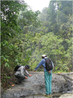
Picture: BGS mapping of the cover rocks in Malaysia that are being used by Singapore to develop underground facilities. Photo: M Stephenson
But this trend will continue. Our changing climate and new developments in energy mean that geologists need to understand the changing processes that affect lives and livelihoods. Luckily there’s a technological revolution going on around us that will enable us to do just that, and to study geological processes as they happen.
Real Time
Meteorologists have long been able to assimilate data in near real-time; but now, environmental scientists and ecologists are getting in on the act. Every new study, whether remotely-sensed or from sensors in rivers or soil, reveals something new about the environment that surrounds us. One startling new development is ‘satellite CCTV’ which allows us to see road-traffic moving in real time, from space.
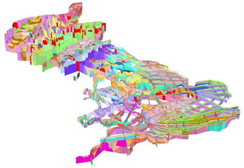
Picture: The GB3d model, published in late 2012, provides a national resolution model of the stratigraphy and structure of UK bedrock geology
But large scale monitoring and measuring in real time has not been a feature of Earth science and geologists have largely missed out. The geological community needs to harness the power of sensor technology to be able to answer people’s questions about the changing Earth at timescales that matter to them – whether it be groundwater flooding, or changes brought about by nearby drilling.
The need for better monitoring and measuring - and therefore better models and predictive capability, as well as the new sensor technology that might enable this – is not lost on BGS. The new BGS strategy ‘Gateway to the Earth’1 outlines some of the challenges that Britain and the world faces - climate change, geological hazards and competing demands for resources - but also shows how sensor deployment will help us answer questions that matter to people. ‘Instrumenting the earth’ will enable better 3D models for predicting such events as groundwater flooding in the southeast, or cliff falls and erosion around our coasts, as well as the effects that climate change might have on built infrastructure, such as railway embankments. It will help us build better models for subsurface developments in cities for example, geothermal for heating and air-conditioning.
But the deeper subsurface of Britain has large untapped potential too: for energy, storage and disposal. Apart from shale gas, there’s coal-bed methane, underground coal gasification, geothermal, nuclear waste disposal and carbon capture and storage (CCS). Our dense population and already heavily-used underground require that we manage the subsurface much better than we have so far - not just for understanding the processes, but also to assure the public that we are competent. Part of BGS’s job is to inform Government regulators and we will work with them to make real-time data available to the public to encourage transparency and to improve public ‘buy-in’ and trust. A combination of good regulation and public buy-in could be a powerful enabler for home-grown and secure, low-carbon energy, for example.
 Sensors
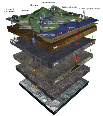
Picture: Britain has large untapped potential for greater subsurface usage; but our densely packed population requires high levels of subsurface management and environmental security assurance to realise this potential. Monitoring and measurement will be a large part of this.
BGS has already started to deploy sensors and is investing in equipment to measure conditions in groundwater to ground-truth our models, as well as in more seismometers to improve our national network so that we can measure induced seismic activity connected with past, present and future energy activity.
Of course, we need more than just sensors. Where they should be placed, what they measure and how often they measure - and a whole host of the other questions - need to be answered. These are partly informed by having some understanding of Earth processes in the first place; but also a deep understanding of the solid geology. Solid geology – the rocks – is what the fluids that we’re interested in flow through. It is the solid framework in which we will hang our sensors.
BGS has over a hundred solid geology 3D models of various kinds. One part of BGS strategy is to meld these into the National Geological Model – a seamless model representing the whole of onshore and part of nearshore UK. In December 2012, BGS released the first downloadable versions of GB3D -the National Bedrock Fence Diagram2 - and the National Geological Model will essentially fill in the gaps. The Netherlands already has a complete 3-D lithostratigraphic framework model3 for the onshore, and the benefits are huge – for government, for industry and for the public.
BGS models are also lithostratigraphic – in other words divided into units based on traditional stratigraphy - and for many of the uses to which we will put these models, this division will be fine. But some fundamental properties of rocks do not always correlate with lithostratigraphy and in the gap between the upper boundary of a lithostratigraphic unit and the lower boundary a lot can happen - there can be a lot of heterogeneity, as well as faults and fractures.
Picture: Aeromagnetic (left), Electromagnetic (centre) and Gamma Ray Radiometric (right) Tellus airborne survey data, Northern Ireland. Coastline © Crown Copyright DMOU205

Focused
So much of the work we’ll be doing in the next few years will be about adding this new knowledge about properties to our National Geological Model. Beyond the focused studies already going on, for example for nuclear new-build and the high-speed rail link HS2, we’ll be out collecting new data. These will integrate with geological mapping, geophysical, geochemical and remote sensing methods, building on the success of projects such as Tellus4 and Maremap5. We will be up-front about the uncertainties in our interpretations, models and forecasts, not only to inform better risk management but also to build public confidence in the transparency and objectivity of our science.
Not that we shall confine ourselves to Britain! One of the most exciting current scientific projects in Southeast Asia is helping to build models of the Permo-Triassic sedimentary rock cover in Singapore. On a crowded island, space is at a premium and so Singaporeans are going underground, hollowing out caverns for oil and gas storage, and ultimately for car parks, utilities and many other uses. BGS is mapping the cover rocks there and in nearby Malaysia to understand their properties.
 Arrays
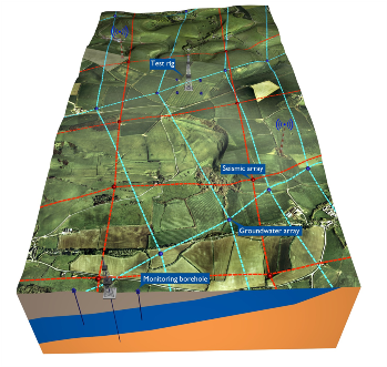
Picture: New energy developments like shale gas will need better regional monitoring.
Instrumenting the Earth is not all just about applied science. Having sensors where we have never had them before will give rise to all kinds of new science. New, denser seismological networks will act like distributed radio-telescope arrays that survey the sky; only these will pick up seismic activity on the far side of the Earth, revealing deep structure better. Other sensors may pick up subsurface biological activity, or unforeseen hidden biogeochemical linkages between surface processes and the subsurface.
This is an exciting time for the British Geological Survey. Our high profile has handed us some very public challenges, but the technology is now available to rise to them. We have a long history of collecting and analysing. We made maps, then 3D models; now we will make those models work for the public, industry and government by ‘instrumenting the Earth’ so that we can solve geological problems and make a difference to people’s lives and livelihoods.
Postscript by the author:
In late January 2015 the Chancellor George Osborne announced that the Government will allocate £31 million capital to create subsurface research and test centres through the Natural Environment Research Council (NERC) and the BGS. The initiative known as the Energy Security and Innovation Observing System for the Subsurface (ESIOS) will develop surface and subsurface networks of sensors to monitor and test energy technologies including shale gas, geothermal and carbon capture and storage. The data will be made freely available to the public. This is a great development for BGS and a palpable achievement for the ‘Instrumenting the earth’ concept.
* Mike Stephenson is BGS Director of Science and Technology and the author of Shale Gas and Fracking – the science of the controversy (Elsevier 2014)
References
- http://www.bgs.ac.uk/ebooks/gateway_to_the_earth/index.html
- http://www.bgs.ac.uk/research/ukgeology/nationalGeologicalModel/GB3D.html
- http://www.academia.edu/3169883/TNO_-_Geological_Survey_of_the_Netherlands_3-D_Geological_Modeling_of_the_Upper_500_to_1_000_Meters_of_the_Dutch_Subsurface
- http://www.tellusgb.ac.uk/
- http://www.maremap.ac.uk/index.html