Tom Sharpe recounts a harrowing tale of geological derring-do in the South Atlantic.
 On 30 August 1916, 27 year-old James Wordie FGS and his companions were huddled in the cold, filthy darkness of their makeshift hut on the bleak north coast of remote, ice-covered Elephant Island where they had been marooned for four and a half months. Patiently awaiting a meagre lunch of boiled seal bones and seaweed, a shout brought them rushing out, scattering their cooking pot on the way, to see an approaching ship. Within an hour, lunch forgotten, Wordie was on board the Yelcho, clutching his diaries and a bag of 30 rocks. These were all he had to show for two years as geologist on Ernest Shackleton's Imperial Transantarctic Expedition.
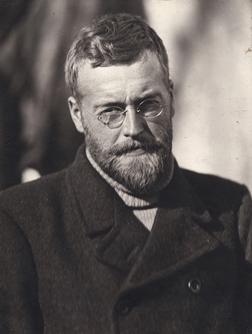
Picture: James Mann Wordie (reproduced courtesy of the Scott Polar Research Institute, University of Cambridge).
Distinction
Born in Glasgow in 1889, James Mann Wordie graduated in 1910 with distinction in geology from Glasgow University before moving to St John’s College, Cambridge. There, in 1913, Wordie met a group of scientists, recently returned from Captain Robert Falcon Scott’s British Antarctic Expedition, who were now based at the Sedgwick Museum. Inspired and encouraged by Scott’s geologists (Raymond Priestley, Frank Debenham and Griffith Taylor) and physicist Charles Wright, in March 1914, Wordie applied to join Sir Ernest Shackleton’s proposed expedition to cross the Antarctic continent from the Weddell Sea to the Ross Sea. Shackleton also planned to send scientific parties to explore the region at the head of the Weddell Sea and to establish the relationship of Graham Land to the rest of the continent. It was to one of these that Wordie was to be assigned.
The expedition ship Endurance set sail on the eve of the outbreak of the First World War and Wordie joined it at Buenos Aires. His geological work began when they reached South Georgia. During November 1914, while the ship was at the whaling station of Grytviken, Wordie collected rock specimens from at least six sites on the island and began a geological map, recording the much-folded structure. These were to be the last outcrops Wordie saw for 16 months. Within six weeks of their departure from South Georgia on 5 December 1914, Endurance was locked in the pack ice of the Weddell Sea. It was to remain so for the next 10 months.
Pitied
 Thomas Orde Lees recorded in his diary (16 October 1915) “The scientist most to be pitied on this expedition is Wordie, the geologist, for his métier lacks the necessary materials at sea …”. But he did have some rocks to work on, as Shackleton explained in South: “The geologist was making the best of what to him was an unhappy situation; but was not without material. The pebbles found in the penguins were often of considerable interest, and some fragments of rock were brought up from the sea floor with the sounding-lead and the drag-net.”
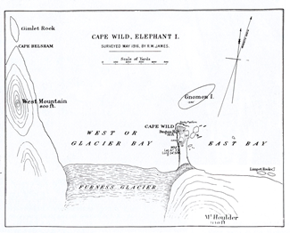
Picture: Map of Cape (now Point) Wild by Reginald W. James of the Endurance Expedition, May 1916. The Furness Glacier has receded since 1916 and now lies near the bottom edge of this map.
The dredge could provide sizeable specimens: on 29 March 1915, Wordie hauled in a boulder of red grit weighing about 20kg and a smaller block of fossiliferous limestone. A month later the dredge brought up several hundred pebbles in glacial mud and sand. The innards of Emperor penguins, especially, proved a treasure-trove of rocks, with one bird providing two different kinds of granite, other igneous rocks, grit and several different sandstones. From these and the dredged material, Wordie was able to conclude (correctly) that the geology of the Weddell Sea coast more closely resembled that of Victoria Land on the far side of the continent than that of adjacent Graham Land.
By August 1915 Endurance had been carried over a thousand kilometres west and north by the rotational current of the Weddell Sea Gyre, but slowly the pressure of the moving ice was crushing the ship and on 27 October 1915, Endurance was abandoned. The men set up camp on the ice and less than a month later Endurance sank, taking with it Wordie’s South Georgia rock collections. But the loss of the specimens was the least of their worries.
 Shackleton and his 27 men spent the next four months dragging their three lifeboats and camping on drifting ice floes before taking to the boats when the ice finally broke up in April 1916. The remarkable navigational skills of Frank Worsley, the Captain of Endurance, got them to Cape Valentine, the most easterly point of Elephant Island on 15 April 1916. They hauled their boats ashore and set foot on land for the first time since leaving South Georgia 16 months earlier. It soon became clear, however, that the beach was swept by storm waves, so the party was forced to relocate seven miles west along the north coast of the island to a rocky point and boulder spit they named Cape Wild.
As geologist, perhaps Wordie was particularly glad to see land; during his brief stay at Cape Valentine, he found time to collect half a dozen specimens, and while sailing to Cape Wild made note of the dip of the foliation in the rocks exposed along the coast which he described as “about as inhospitable as one could well imagine”.
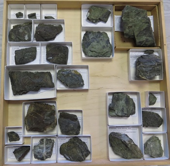
Picture: Wordie’s Elephant Island specimens in the Hunterian Museum, University of Glasgow. (photo: Tom Sharpe; reproduced courtesy of the Hunterian Museum, University of Glasgow).
Elephant Island
Although Elephant Island offered refuge, there was little chance of rescue; so Shackleton took five of the party back to sea in an audacious, but ultimately successful attempt to reach South Georgia - over 1200 kilometres away - to seek help from the whalers there. Organising the rescue of his men would take Shackleton over four months, and success would come only at the fourth attempt.
The 22 men remaining at Cape Wild spent the winter in a cramped hut made from their upturned boats. There was little opportunity to explore, as the site was hemmed in by impassable cliffs and ice (which Wordie did try, unsuccessfully, to climb). He combed the beach for erratics, and recognised that the bouldery spit on which they were camped was the right lateral moraine of the Furness Glacier, which rises steeply above Cape Wild. He was also able to collect specimens from the local bedrock, “a dozen or so fairly representative rocks. The rocks are unfortunately very monotonous - metamorphic schists - and the amount of rock accessible is extremely small”.
 When Shackleton arrived on the Yelcho off Cape Wild at about 1300hrs on 30 August 1916, the men had little time to organise their departure. Ever the geologist, Wordie made sure he took some of his specimens with him. “The end was rather a hurry” Wordie later wrote in his diary: “ … it was best to cut and run. And so all my beach exotics are left behind: the only rocks I have are those in situ. But can one complain? - My notes are safe and every man is safe”.
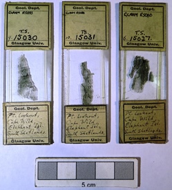
Picture: Some of the thin sections prepared by G.W. Tyrrell from Wordie’s Elephant Island specimens. (photo: Tom Sharpe, reproduced courtesy of the Hunterian Museum, University of Glasgow).
Once in Chile, Shackleton put Wordie in charge of the expedition’s scientific results which were summarised in an appendix in South. The rocks Wordie brought back (six from Cape Valentine and 24 from Cape Wild, were the first to be collected from Elephant Island and were described by G W Tyrrell in Wordie’s 1921 paper on the geology of the Weddell Sea area. Tyrrell struggled to make sense of them, but today we recognise them as Cretaceous chloritic schists of the Scotia Metamorphic Complex. The collection survives in Glasgow University’s Hunterian Museum where, neatly arranged and curated, it belies the tale of incredible hardship suffered by the expedition and of the endurance of Shackleton’s geologist.
Acknowledgements
 Thanks are due to John Faithfull, Hunterian Museum, University of Glasgow; Lucy Martin, Scott Polar Research Institute, Cambridge; Joy Wheeler, Royal Geographical Society; Wendy Cawthorne and Caroline Lam, Geological Society Library; and Linda Norton.
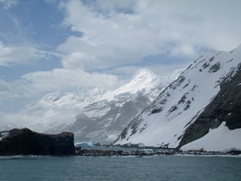
Picture: Point Wild from the west. Lookout (Penguin) Hill is to the left (photo: Tom Sharpe).
Further reading
- Shackleton, E 1919. South. The Story of Shackleton’s Last Expedition 1914-17. London: William Heinemann.
- Smith, M 2004 Sir James Wordie Polar Crusader. Exploring the Arctic and Antarctic. Edinburgh: Birlinn
- Smith, M 2014 Shackleton. By Endurance We Conquer. London: Oneworld.
- Sharpe, T 2014 On the rocks on Elephant Island. The James Caird Society Journal, 7, 21-32.
- Wordie, J M 1921 Shackleton Antarctic Expedition 1914-17; geological observations in the Weddell Sea area. Transactions of the Royal Society of Edinburgh, 53, 17-27.
* Tom Sharpe is Chairman of the History of Geology Group.