Graham Leslie*, Mark Cooper§ and Brian McConnell¶ have recast the regional geological map of northern Ireland in 3D
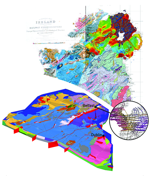
Caption: Version 1 geological model of the north of Ireland, major faults are shown in red. The modelled surfaces indicate the base of each geological System: the Palaeogene lavas (lilac) cap the Antrim Plateau in Northern Ireland; the Carboniferous limestones (blue) dominate the Irish Midlands. The model is currently bound by a c. 350 km long section drawn from Benwee Head in the NW to Carnsore Point in the SE.
For almost two centuries, geological maps have been used to deliver knowledge and understanding of the rocks beneath our feet. Those maps, along with their complementary cross-sections, can provide information in two, three or even four dimensions; but the depth of understanding achieved in that exchange is strongly dependant on the knowledge and experience of the user. An exciting, and potentially more dynamic, future lies in using modern computing power and web-delivery to provide widely accessible 3D models of national geology. Those same media can also seek contributions on-line from across the geological community that enhance the viability and robustness of any released model or derivative products.
Caption: The array of data incorporated into the V1 3D geological model of the north-eastern half of Ireland.
The British Geological Survey (BGS), Geological Survey of Northern Ireland (GSNI), and the Geological Survey of Ireland (GSI) are now collaborating to build a 1:500 000 scale, 3D model of the upper crust of Britain and Ireland. To develop a methodology for future work, the partners have constructed a ‘Version 1’ test-block of the north-eastern half of Ireland. Currently, that model comprises a System-based stratigraphy, and an array of regionally important faults that divide the model into component blocks sharing a recognised geological history.
Stacked surfaces in the model represent the base and areal extent of individual geological units: for example, the spread of Carboniferous limestones that dominates the near-surface bedrock geology of the Irish midlands. The north-eastern Irish model is already providing a regional context for enquiry-driven, higher resolution case studies, such as the Belfast urban geological model. This new model is being constructed in consultation with Belfast City Council and other stakeholders in order to inform future sustainable urban development.
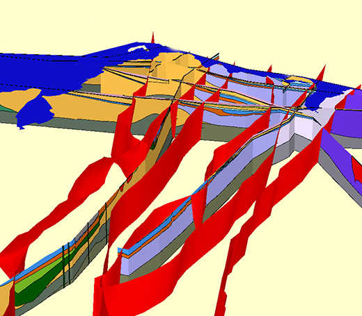
Caption: Close-up of geological cross-sections and faults (red) that form the framework on which calculated surfaces hang.
NATURALLY COMPLEX
Physical reality is three-dimensional. Earth systems and processes are naturally complex and operate, through time, in those three dimensions. A 3D model projects the geologist’s understanding of this natural order and complexity. Identifying national resources, (energy, minerals and groundwater) and geo-engineering the infrastructure that secures their supply, both depend upon a consensual, national geological understanding. In the north of Ireland, the multi-award winning Tellus Project and current Tellus Border Project are addressing shortcomings in the regional baseline data for environmental protection and sustainable resources (www.bgs.ac.uk/gsni/tellus/ & www.tellusborder.eu/). Vast geophysical and geochemical datasets are now available to investigators and researchers. Integrating these rich new data with the existing geophysical and geochemical information, (e.g. seismic, gravity, soils), is rapidly providing fresh insights into the geology of Ireland, and a robust 3D model can provide the platform upon which they can be fully exploited. The model should be able to absorb any data (whether new or ‘legacy’, outcrop, borehole or remotely sensed) and then be regenerated with quality-assured attributes. It should be dynamic! The geologist’s task is to communicate the essence of that 3D model, and so help government, industry, research and education to take properly informed decisions.
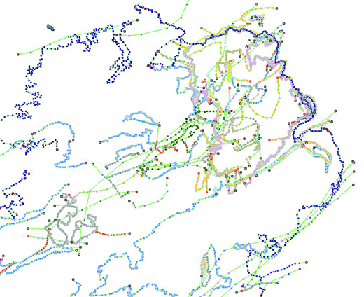
Caption: The outcrop and subcrop limits of Systems (spaghetti).
SCRIPT TO SCREEN
Constructing a geological model for the north-eastern half of Ireland, one that extends down to a depth of 15km, can only be described as an awesome challenge - not least in the sense that we encompass a volume of some 700,000 cubic kilometres of rock. To achieve a geologically realistic model, it is necessary to integrate knowledge and understanding that has been accumulating since 1838, when Sir Roger Griffiths’ geological map of Ireland was first published, and encompassing modern regional geological maps (themselves summations of countless years of fieldwork), academic research, records from deep boreholes and the Tellus datasets.
In recent years a wide range of 3D modelling packages have become available, but, for its geologically intuitive nature, the ‘first build’ for north-eastern Ireland was made using GSI3D software, developed jointly by BGS and INSIGHT GmbH. Steve Mathers, Holger Kessler and Ben Wood (all BGS) have provided continuous support and encouragement to the geological team. GSI3D (which stands for ‘Geological surveying and investigation in three dimensions’) is described by its developers as a methodology for 3D geological modelling that enables the geologist to quickly capture data and construct sub-surface models, for a wide range of consumer applications. The software is now available on general release through the not–for–profit GSI3D Research Consortium (www.gsi3d.org/) and is rapidly becoming one of the preferred assets in the geologist’s toolkit.
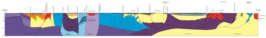
Caption: Geologists’ cross section from Benwee Head to Carnsore Point derived from geological mapping and geophysical information.
GSI3D uses geological cross-sections and boreholes to constrain model surfaces at depth. Few such sections existed for the crustal-scale model under construction, and the available borehole data have limited impact at this resolution. Our first step therefore was to build a regularly distributed network of 15km-deep sections across the area of interest. These detailed sections were compiled so as to capture current understanding of System-based stratigraphy and regional tectonic structure. Regular consultations with other experts on Irish geology provided further constructive input to our efforts.
The sections were then stripped down to provide a simplified skeleton on which key surfaces were calculated and displayed. GSI3D takes a ‘younger over older’ stratigraphical approach to the model calculation and, at this stage in its development, cannot directly deal with ‘older over younger’ rock relationships, as encountered with reverse faults and overturned strata. This has been overcome in the V1 model by adopting a tectono-stratigraphic approach to the units defined for the model’s generalised vertical section (or ‘GVS’). Lessons learned in these scenarios are being fed back to the GSI3D software developers.
In addition to the cross-sections, a network of regionally important faults, such as the Tempo-Sixmilecross Fault, divide the model into discrete blocks. In order to permit calculation, these model faults must, at present, be extended downwards from the capping topographical surface (digital terrain model, or ‘DTM’) through the full model thickness. However, faults associated with the Iapetus Suture in Ireland are largely concealed at surface by Carboniferous strata. Others, by contrast (such as the Orlock Bridge Fault) do cut all the way to the surface and are thus conspicuous features of the conventional geological map. Where appropriate therefore, the section lines have been constructed with minimal or no offset of geological units across these concealed master faults.
OUTCROP, SUBCROP
The extent of the lower surface of each geological unit is established from exposed (outcrop) and/or concealed (subcrop) limits. Deep borehole records and geophysical interpretations are then incorporated with those crops, to gauge the extent of concealed sedimentary basins. The calculation integrates all of those limits with constraints provided by the cross-sections, faults and fault-offsets to deduce the model surfaces. Since the lower surface of each rock unit is also the upper surface of the underlying unit, the enveloping surfaces for each volume are therefore complete and Version 1 of the geological model is revealed. New or additional data can be rapidly added to the calculation as required.
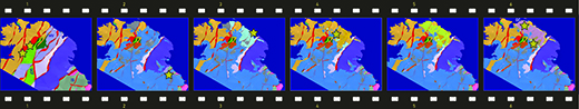
Frame 1 shows that deformed and metamorphosed Neoproterozoic strata dominate the NW of the model (beige) and lie to the NW of the Galway-Carnlough Fault (GCF) system, a structure that potentially marks the edge of the Laurentian craton in Ireland.
The Stars highlight economically viable gold deposits in these rocks, while exploration for volcanogenic massive sulphide deposits (VMS) is taking place in adjacent Ordovician rocks (green). The southwestern continuation of the Scottish Midland Valley (MV) is clearly seen - but apparently terminates in the SW against the Galway-Carnlough Fault system. Farther to the SE lies the Lower Palaeozoic Accretionary Wedge and its major tract-bounding faults. Another set of major faults is shown in the convergence zone above the Irish trace of the Iapetus Suture (IS). To the south are the basal surfaces of the Lower Palaeozoic of SE Ireland.
In Frame 2, Devonian (brown) and Lower and Upper Carboniferous rocks (blue and grey) are added. The Lower Carboniferous rocks host the world-class Pb-Zn deposits of the Irish Midlands (e.g. Navan -starred), while the Upper and Lower Carboniferous contains important hydrocarbon source and reservoir rocks. The Northern Ireland Permian (light blue – Frame 3) encompasses a thick halite interval, which is a target for natural gas storage; while Triassic rocks (orange, Frame 4) are important groundwater reservoirs and have hydrocarbons and deep geothermal energy potential (starred).
The Jurassic (yellow) includes important hydrocarbon source rocks and seal. Cretaceous strata (light green, Frame 5) consist of extremely pure white limestones, valued as a raw material. Last but not least, we have the base of the Palaeogene basalts (lilac, Frame 6) famous for the World Heritage-listed Giant’s Causeway (GC) and the Oligocene lignite-bearing deposits (dark green) of the Lough Neagh Group on top (starred). When stacked together, the surfaces broadly recreate the published map in plan view – as they should. Further information on this and other Northern Ireland models can be found at www.bgs.ac.uk/gsni/geology/3d/index.html.
TO BE CONTINUED
Of course, we accept that our ‘V1’ crustal-scale model of north-eastern Ireland is not yet ‘fit for purpose’. The fault framework is still too simplistic and requires further shaping to match the complexity of the crustal-scale fault architecture seen across Ireland. Although visible in the component cross-sections, the major plutons are yet to be calculated as 3D objects in the model. While those enhancements are introduced, we intend to expand the model across the rest of Ireland and Great Britain, onshore and offshore.
We also accept that the collaborating geological surveys are not sole arbiters of a national geological model. As other 3D models (or their component objects) become available at a variety of scales and from a variety of sources, any national geological model must respond and incorporate those data – irrespective of whether those data derive from resource exploration or ground investigation. Faults and stratigraphical limits can then be recast in 3D. Such upgrades to the national model can be achieved - perhaps most effectively - in the form of ‘versioned’ downloads that clearly state the provenance of the datasets and ideas incorporated in that particular build.
The World Wide Web provides the ideal forum; crowd-sourcing external data, allowing uploads to a (mediated) web site that can then deliver model updates once those new inputs achieve the required level of confidence and quality assurance. In this way, we think that the national geological model would truly be nationally owned.
Authors
* British Geological Survey
§ Geological Survey Northern Ireland
¶ Geological Survey of Ireland
Acknowledgments
Construction of the V1 crustal scale model of the north-eastern Ireland was funded through Tellus 2. Staff resources were made available from all three surveys (GSNI, BGS & GSI) to allow this first model to be produced. The authors acknowledge geological and technical input from the GSI3D team, Sarah Arkley, Bruce Napier, Alex Donald, Calum Ritchie and Tony Myers. This article is published with permission of the directors of the UK and Irish surveys.
References
- Smith, M & Howard, A 2012. The End of the Map? Geoscientist 22.2, pp19-21.
- Kessler, H & Mathers, S J 2004. Maps to models. Geoscientist 14.10, pp4-6.
- Geological Survey of Ireland, 2006 1:500 000 Bedrock Geology
- Griffith 1838 bedrock map of Ireland
- GSI3D Research Consortium: www.gsi3d.org/
- Tellus Project: www.bgs.ac.uk/gsni/tellus/
- Tellus Border: www.tellusborder.eu/