
A stroll along the prom – Swansea Bay
By the good grace of the municipal authorities, a CAR PARK is provided for our use at the start of this tour. You may leave your car here and walk the course, or alternatively you may choose to drive to each stop; there is parking space available near every one. Should you decide to walk, the route is a little over four miles long, and there is a frequent bus service to return you to your car. You should ask the driver for Blackpill.
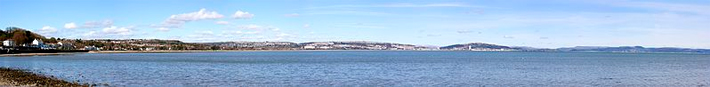
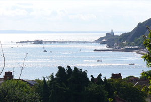
 Picture - Swansea Bay (West) viewed from one of the Pennant Sandstone hills behind Sketty. In the distance is Mumbles Head, composed of older Carboniferous Limestone. Photo courtesy, John Powell
- Map of the route Take the coast road out of Swansea. Pass the Cenotaph on the embankment to the left and two sets of traffic lights, before arriving at a third. Carry straight on for about half a mile, until the road is joined by another from the right. Turn right here and enter the CAR PARK on the left. This is a Pay & Display - charges apply.
Leave your car here and cross the main road. Go past the mini boating lake and stand on the concrete footbridge that crosses the small river. This was once the site of the famous Mumbles Railway, the earliest passenger-carrying rail-transport system in the world. Much of the ensuing walk is established upon the line of this tramway, which ran from Swansea to Mumbles Pier. It was closed in the sixties.
Look to the south-east and follow the shape of the land from the furthest headland towards Port Talbot, which is the first noticeable town on the coast, with its steelworks. The sudden increase in height of the land behind the immediate coastline is the result of resistant Coal Measure sandstones coming to the surface on the southern limb of the South Wales Coalfield syncline. The flatter land to the south of this hilly region is made up mostly of Triassic and Jurassic rocks overlying the eroded basement of folded Carboniferous rocks. You are, in effect, looking at an ancient coastline, because as the younger strata get thinner northward, they also develop into sediment types more characteristic of shallow water. Older Triassic rocks beneath lie directly upon basement and are the deposits of large, fan-.shaped screes formed by desert-erosion of high mountains, which are now only the rounded hills you see before you. Only one small patch and a few infilled fissures now remain to tell of a similar Triassic cover over Gower.
 Above Swansea stands Kilvey Hill: a brownish-black, rounded hill like those over Port Talbot, and made of the same rocks. It has a television mast on its summit. The other hills on which Swansea's northern and western suburbs are built, also stand on northerly-dipping Carboniferous rocks, whose geology closely controls the topography of the town.
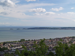
If, for example, you were to drive northwards from Swansea to joint the M4 at Llangyfelach, you would notice several distinct ridges that the road must traverse. These are the thick formations of sandstone - look out for quarries and cuttings on the way - and the valleys that lie between them are formed along the intervening shales and coals. These valleys and escarpments run east-west, and they are cut across, on the west side of Kilvey Hill, by the other major feature of the Swansea landscape, the Swansea Valley. The picture above is taken from one of these Pennant Sandstone ridges.
Anyone coming to Swansea on the train will, after having left Neath, have descended into the Swansea Valley from the high land which separates the two depressions and traversed the broad, level valley floor towards the Landore Viaduct. This wide, glaciated valley, a cradle of the Industrial Revolution and once the largest area of industrial- dereliction in Europe, is filled and flattened by the sediment deposited by the retreating glacier. This tongue of ice carved the valley along the line of one of Wales' major fault-lines the Swansea Valley Disturbance.
Much of the valley, and also much of Swansea Bay itself, is filled with this glacial debris. The exact course of the Swansea Valley Disturbance is not known for certain in the immediate vicinity of the city, but it probably meets the sea along the northern edge of the Gower peninsula, having veered westwards somewhere to the north.
Nevertheless, many other faults come to the coast in the bay itself. Not all are major features like the Swansea Valley Disturbance, though the Neath Disturbance (which controls the Neath Valley in similar fashion) is of comparable scale. At any rate, these numerous faults, all converging here, have resulted in the formation of this extremely wide and dramatic harbour.
(Note that the term 'disturbance' is meant to convey a zone of complex faulting rather than a single fracture-line. Most of the major faults of Britain are similarly complex, but only in South Wales, it seems, are they called 'disturbances'.)
The sandstones of Kilvey Hill and the hills of outlying areas of Swansea are called the Pennant Measures, and lie above the Lower and Middle Coal Measures which are richer in shales and have fewer, thinner sandstone beds. This is why they give rise to a more subdued topography to the south of the Pennant Hills, across the northern 'neck' of the peninsula and directly surrounding the head of Swansea Bay itself. As you continue around the path, you will be walking on these rocks until you reach West Cross (Stop 2).
Now let your eye follow the coastline around the western arm of the bay, and notice how level the skyline becomes towards Mumbles. it lies at a fairly constant 70 metres (200 feet) above sea level, as does much of Gower. This level topography is called a peneplain, an ancient marine erosion level, formed when the sea was 200 feet higher (relative to the land) than it is today. Sea levels have fluctuated widely in the last 2 million years, as a result of the dramatic variations in climate that the Ice Age involved.
The Ice Age really consisted of a series of advances and retreats of the polar ice-caps, which were interrupted by interglacial periods lasting many thousands of years during which time the climate was much milder - in many cases even warmer than it is today. The last ice left this area about 18,000 years ago: but there is no reason to believe that it will not return, nor that present conditions represent anything more than another brief respite in a predominantly glacial age.
 The retreat of the ice resulted in the deposition of many different kinds of glacial sediment in the region. The actual bedrock of Swansea Bay, for example, is some 600 feet below the present seabed. In the area of the town, however, the most common deposit is boulder clay (also called glacial till), which is a mixture of clay and massive boulders dumped by the melting glaciers. Singleton Park, lying behind the University campus and which deserves a visit, displays well the hummocky topography typical of this kind of glacial deposit.
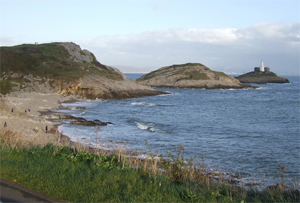
The lighthouse at Mumbles (left, from behind Bracelet Bay) stands on the outer of two islands made of Carboniferous Limestone - as is much of the coast leading up to them. So it should be clear, bearing in mind the ordering of the rock units that the rocks are indeed becoming progressively older to the south.
 Before leaving Blackpill, take a look at the valley from which the stream is emerging; and if you have a map, examine its course and depth. This relatively deep gorge, once the LMS route to the North of England, is now a country walk and well worth a few hours of your time. In times gone by, it was the site of much early industry - particularly coal-mining and brick-making -and it is cut along the approximate line of demarcation between Lower and Middle Coal Measures. Interesting cuttings along the way show you what the rocks of this portion of the Carboniferous look like, and there is a pub at the end of the path, two miles away in Killay.
It may strike you as you walk the route, or even as you examine the map, that such a diffident little stream seems an unlikely erosive agent for such a deep depression. It is, in fact, a so-called misfit stream, making use of a valley created by much more vigorous torrents at the end of the Ice Age. Many valleys around Swansea owe their origin to the drainage of glaciers, as shown by the fact that many have no stream in them at all - above Hendrefoilan Student Village, for example.
Carry on now, past the boating lake until you come to a large public house with a small forecourt CAR PARK - the West Cross Inn. On this section of the coast-path ahead of you, the best panoramic views of Swansea Bay are to be gained. If you do not intend to patronise the pub, there is a municipal CAR PARK on the opposite side of the road. To get to this, you must turn right at the T-junction before the pub, then first left and first left again. Go past the row of shops and enter the car park on the right.
Stop 2 - West Cross
To examine this locality, you will need to arrive when the tide is at least partly out. Look over the wall separating the coastal path from the beach. Notice that among the loose boulders, traces of bedrock can be seen poking through the sand. (Geologists would refer to this as rock in situ, meaning 'in place', so as to distinguish it from rock moved from its original site by surface processes.)
The rocks here are exposed in the eroded core of a small anticline, an upfold that has been planed flat by the sea. It is a useful small-scale demonstration of an anticline, since a) you can see the hinge very well, running at right-angles to the coast and b) the rocks can be seen dipping away on either side.
Notice the shape of the outcrops - pick one prominent bed and follow it. You can actually walk along one, if you wish. Alternatively, if you go and stand in the middle of the structure, you will see that the beds crop out all around you, and are dipping away from you in all directions.
This is because this anticline is like an upturned boat, with the hinge-line running along the keel. Each bed may be envisaged as having this boat-like shape, and there are many 'boats' stacked one inside the other. The sea has cut into the stack like a chainsaw, producing the features you are seeing
This tells us something important. Anticlines and synclines do not go on and on for ever all around the world; they have to stop somewhere. Where they do, the dips radiate around what is called the nose of the fold. A fold like this, where you can see both ends, is called a pericline - but as I have said, all folds are to some extent periclinal.
Folds may also be angled into the plane of erosion. Such folds, whose axial traces lie at an angle to the horizontal are said to "plunge". Erosion of a plunging fold produces similarly curved outcrops, but with a closure at only one end, and diverging arms at the other. We shall see a plunging fold in the fifth excursion.
Now - a word about the rocks making up the pericline. These are the Namurian shales immediately underlying the lowest Coal Measures. As you can see, they are very fine-grained, and not a bit suited to their other name, which is 'Millstone Grit'. This incongruity illustrates one of the problems in naming rock-types and rock-units.
The rock-type which, in the past, genuinely was used for the manufacture of millstones was not laid down in Gower. Instead, at the same time, fine shales and mudstones were deposited. So these rocks you see here are the same age as the 'Millstone Grit', but are of a completely different rock-type (litholoqy).
This is because their environment of deposition was different. The true Millstone Grit was a very shallow-water deposit, and it so happens that over Gower the water was deeper, and the sediments consequently finer. But we can tell that they are the age-equivalent of their coarser counterparts by their contained fossils.
The name 'Millstone Grit' is therefore a 'lithological' term. The term 'Namurian', on the other hand, is the name given to the period of time luring which all rocks of this age were deposited. It is therefore a 'chronological' term, and can refer to any rock type of the specified age. That is why you can say "The Millstone Grit was laid down during the Namurian" but not "The Namurian was laid down during the Millstone Grit". That would be like saying: "I picked the afternoon during cockles".
You should now continue your walk as far as the bus terminus at Oystermouth. There is ample PARKING SPACE along the seafront - carry on a little way and turn left after the bowling greens and tennis courts.
Stop 3 - Oystermouth
The effect of the syncline is to bring the Namurian back to sea-level. These shales and mudstones are softer than the surrounding limestones, and since they are more easily eroded, they have given rise to a valley and a notch in the skyline. If you stand at the junction with the mini-roundabout, near to the public conveniences, you will notice that the road coming down the hill is at a lower level than the land on either side. If you follow this road, passing all the shops and the turning to Oystermouth Castle, you will come eventually to a wide hollow, with playing fields. The high ground surrounding this depression is made of limestone, and the road itself traces, more or less, the hinge of the Oystermouth Syncline.
Now walk back a little way towards Swansea, keeping to the landward pavement of the coast-road. In about 300 yards you will find a track leading to a Long Stay CAR PARK - situated, conveniently, in a quarry. This is Clement's Quarry, and the regularly bedded rocks you see here are the topmost strata of the Carboniferous limestone.
First, before looking at the rocks themselves, look at the direction of the dip. Can you see that the dip on the exposed face at the back of the quarry is different from that seen in the quarry wall to your left? The dip is veering around here, in a bigger example of the structure we saw in the West Cross pericline. In fact, this quarry has been cut into the nose of the Colts Hill Anticline. This is becoming increasingly difficult to see now that the quarry walls are becoming covered in vegetation.
The rocks themselves are rhythmic alternations of black limestone (which weathers white) and a softer black shale. There are many arguments about how this regularly interbedded pattern came about, but there is a strong possibility that it had some seasonal or climatic cause.
When sediments are very black, it tells the geologist that they are rich in carbon-compounds or sulphides - or, as is often the case, both. In normal sediments, these do not survive the natural processes of oxidation - ie., combination with free oxygen to form oxides. Carbon usually finds its way through various biochemical processes to carbon dioxide, and sulphur goes to form soluble sulphates. But when oxygen is lacking in the sediments, due to stagnation of the water above them, for instance, then organic material cannot be broken down and substances such as iron will go to form the compound iron sulphide instead of iron oxide.
This is why, if you strike many black sediments with a hammer and smell the gases given off, you will smell petroleum (organic carbon) and/or rotting eggs (hydrogen sulphide). You may also see glints of fool's gold, iron pyrites - which, in chemical terms, is iron sulphide. If you have a hammer, try also using your ears as well as your nose The distinctive ringing note which this limestone makes when it is struck with a hammer has given it the quarryman's name of ‘chinastone’.
There are plenty of places offering refreshment in Oystermouth, and you might like to take advantage of them before completing this trip. If you are on foot, you have about a mile left to walk; if you have your car, then CAR PARKS are to be found all along the next stretch of the road, as far as the Knab Rock jetty. Just after the Knab, a road forks off left and leads to the pier. Here, too, there is a CAR PARK. The next stop is an exposure in the embankment about fifty yards along this driveway.
Stop 4 - Southend
Note that geological veins are mostly unlike the veins in your body, since they are sheet-like in form, rather like the rippling in raspberry ice cream. In fact, they are commonly found along fault planes, and can be very useful in massive formations like this limestone) for making faults easier to identify.
There has been extensive faulting in this area, and in this case the rock has moved apart under stress to leave a gaping fissure, which has allowed the passage of groundwater. If you have visited the caves at Cheddar or Dan-yr-Ogof, you will know how groundwater in limestone areas carries lime in solution and precipitates it in much the same way as hard water can leave lime-scale in pipes, kettles and steam irons. This is essentially what has happened here.
The banded nature of the infilling shows that precipitation was not continuous, but episodic. Does this mean that the supply of water was fluctuating, or that the crack itself opened a little at a time, in stages? It is very difficult to tell by looking at these layers. At the next locality, however, we may be able to offer an explanation.
The pink staining is iron. You can see it in the vein, but it you try to follow the course of the vein in the cliff above, you should see some much more dramatic iron pigmentation. This iron has been very important along the fault-lines of Gower, and it probably derived by downward percolation of water from a Triassic cover. These rocks consisted of desert sandstones and conglomerates, very rich in iron; so rich, in fact that some of the larger fault-lines have preserved mineable ores.
Looking up to the cliffs above the road you should be able to see, not far away, a deep and steep-sided gully running up the side of Mumbles hill. It is called The Cut, and it was mined along most of its length from Roman times until the end of the last Century. If you are feeling energetic, it is possible to climb this gully and thereby gain the top of Mumbles Hill. After all the effort required getting there, you will probably make light work of the fence at the top. From the summit, you will be rewarded by a fine view and, as you pause for breath about half way up, by the sight of some faint horizontal scratches or, the walls. These were formed when the rock masses slid past each other during faulting. They are called slickensides, and they tell the geologist which way the fault moved.
Should you scale this gully, you will find a convenient track to bring you down again near to our final stop, Bracelet Bay. If you examine your map, you will see that on the western side of Mumbles Head there are, in fact, two bays: Bracelet and Limeslade. Limeslade is a narrow inlet, eroded along a fault-line - the very same fault-line that runs along The Cut. Why do you think the fault has led to the erosion of a bay on one side of this headland and not the other? The answer lies in the direction of the prevailing winds. These attack the southwest-facing coasts without mercy, but the north-east sides of headlands are therefore in shelter. So remember that faults need not always form eroded hollows - intensity of erosion can govern topographic expression very closely.
Those not wishing to scale the north face of Mumbles Hill may go around by the road, whose cutting affords a fine opportunity to examine the Carboniferous Limestone. Notice also the direction of dip. The next stop is the CAR PARK at Bracelet Bay (see picture above). Go to the end of the car park where the restaurant stands. There are public conveniences behind this establishment.
Stop 5 - Bracelet Bay
Stand at the edge of the car park near the restaurant and notice first of all the distinct notch in the skyline near the apple-shaped sweetshop. There is a fault here, and where it emerges at beach level, you will see more calcite veining. After the precipitation of several layers, much of the lining above here was spalled off during subsequent earthmovements. Broken blocks of layered calcite fell into the fissure and lodged where they are now seen. Their presence testifies to several episodes of reactivation along this fault.
More faults like these run between the outer and inner islands, and between the inner island and the mainland. Moreover, each island is itself bisected by a less important fault.
Now look down into the bay itself. If the tide is not fully in, you should be able to see the bedding. The dip of these beds is roughly seawards, which is a major change from the dip at Southend, where it was towards the road. Furthermore, if you look closely at the beds exposed in the bay, you should be able to see that their outcrop pattern is curved. This proves that the dip direction is changing. In fact, the beds are swinging round the nose of another anticline, and the dips are veering just like those in Clement's Quarry (cut, you remember, into the nose of the Colts Hill Anticline). The fold we are looking at now is the Langland Anticline, and we shall see it again when we visit Caswell Bay.
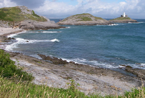 So what controls the shape of Bracelet Bay? From its wide and open form, one can reasonably suppose that it is mainly the folded nature of the rocks. The fold has not brought softer strata into play (as the Oystermouth syncline did, with the Namurian), but the stretching and cracking of the limestone over the fold-hinge has weakened the texture over a wide zone. It contrasts nicely with Limeslade Bay next-door (picture), which is typically narrow - characteristic of fault-control. The picture in fact shows Tutt Head, the headland on which the Coastguard Station stands, separating Bracelet Bay from Limeslade.
This is the end of the first excursion. If you wish to look at more limestone at close quarters, then there is a pleasant walk around Tutt Head, behind you, taking you past the coastguard-station. On your way back, think over the following summary: for today you have witnessed two of the three vital ingredients of Gower geology.
East-west trending anticlines and synclines. The West Cross, Colts Hill and Langland anticlines are typical of many such folds that dominate the structural pattern. They were the principal result of the compression, which deformed the rocks 280 million years ago.
- North-south trending faults. These occur in the coalfield also, and like the one that joins Limeslade Bay and The Cut, they give rise to bays when they intersect southerly coasts. They may show veining, which is episodic, reflecting incremental openings of the fault-fissure. There is often iron-mineralisation, suggesting erstwhile Triassic overburden in the area.
Read next tour...All that you survey (Cefn Bryn)