
All that you survey (Cefn Bryn)
Despite the fact that it is a good idea for geologists to get close-hand experience of rocks, and to use every sense at their disposal to get to know them intimately, it is also very important (and very pleasing) to use the eye of the landscape-painter. In this way, the geologist brings to the view before him (or her) the special knowledge of underlying rock-structure which explains why the hills and valleys are the way they are. Geologists will always have to go out and make maps - their very science depends upon it - and in this difficult task, an eye for the country is an invaluable tool.
If you are travelling from Swansea by car, after you leave Upper Killay, (just beyond the cattle-grid) take the fork to the right and carry on for about five miles. At a place called Cilibion, where there is a filling station and one or two houses, the country opens out to reveal a fine, wide common and the northern slopes of Cefn Bryn. This high ridge is the backbone of Gower, and the road that forks to the left here will take you to the top of it.
On the way, note Broad Pool on your right, and the generally uneven nature of the road itself. Despite municipal attempts to level these out (coaches used sometimes to ground on the undulations) this road still provides an exhilarating ride at illegal speeds.
On the crest of the hill you will find PARKING SPACE on the north side of the road. It is unmetalled and unmarked. (The area to the south of the road has recently been made inaccessible to vehicles.)
You will find it helpful to have your Ordnance Survey map available; this will enable you to pick out some of the features that are not visible - spring-lines and old collieries, for instance. We will explore the top of Cefn Bryn itself a little later. First, I would like to draw your attention to the view that, even on a moderately clear day displays many of the geological features that have fashioned modern Gower. Your best vantage point will be found if you walk from the car park a little way. The length of the summit is traced by a ridgeway called Talbot's Road; walk eastwards for about a hundred yards until you come upon a lookout pillar from which unimpeded views are possible in all directions.
Looking North
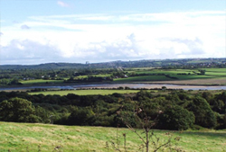 The most obvious feature as you look north is the Loughor Estuary (picture, taken from above Llanrhidian), which separates Gower from Llanelli and Burry Port. This may be the course of the Swansea Valley Disturbance (see tour 1). The hills on the skyline above the estuary are composed of rocks from the Upper Carboniferous, and they are fertile and mostly covered in green fields. You should also be able to pick out the high hills above Swansea, also built of Pennant Sandstone. Kilvey Hill, black and surmounted by a television transmitter, is a good guide.
Now cast your eyes down, to the very edge of the common land below you, just beyond Broad Pool. This edge coincides with the road to Llanrhidian from Cilibion, and on the other side of it the ground is higher and fertile. This belt of rich farmland meets the north coast at a prominent, rounded hill with Iron Age fortifications around its summit. This is Cil Ifor, and the belt of farmland that includes it is made of Namurian rocks.
You will remember that the Namurian lies beneath the Coal measures and above the limestones. Since these rocks are dipping away from you into the Coalfield syncline, it therefore follows that the hills just beyond (which rise slightly higher) are formed by the Lower and then the Middle Coal Measures.
Indeed, the settlements along the north coast of Gower from Crofty to Gowerton were the heart of coal-mining in Gower. They even resemble the towns and villages of the more important coal regions of the central coalfield, with their terraced cottages of Pennant Sandstone and their disused railway-sidings. The rocks that underlie these places can be traced across the neck of the peninsula to the mouth of the Clyne Valley, which we passed on the last tour (Stop 1).
The ground on this side of the Llanrhidian road is underlain by the Carboniferous Limestone. If you came along the road from Cilibion, you may remember that the road was rather uneven after the turning a feature which you were asked to look out for. The reason for those 'ups and downs' is the profusion of swallets and sink-holes which occur there.
These are common features in chalk and limestone country, and they are caused by the collapse of underground caverns created by solution. Swallets are dry craters, but at sink-holes rivers actually vanish into the earth. If you examine your map, you will see several streams originating on the northern slopes only to be swallowed up around Stonyford and Freedown.
The situation here is complicated, however, by the existence of a variable thickness of surface-deposits from the glacial age. These serve to protect the limestones beneath and so keep water at the surface. Broad Pool, for example, is probably an incipient sink-hole which is at present choked with clay.
Look now towards the north-west. Here you should see the long spit of afforested dunes called Whitford Burrows, stretching out across the estuary mouth. Rising above it to the south is a very large hill Llanmadoc Hill - and along the northern edge of this hill runs a deep, almost gorge-like wooded valley. This is Cheriton Valley, carrying the Burry Pill, another nisfit stream, like the Clyne River at Blackpill (Tour 1, stop 1).
This valley is cut into the soft Lower Limestone Shales, the bottom division of the Carboniferous Limestone, and hence also the oldest rocks of the Carboniferous System. They are nearly everywhere responsible for marked gullies like this one, and hence they are poorly exposed and difficult to study.
The rocks on the northern side of the valley are harder, and rise to form good limestone cliffs along this part of the coast - although since the estuary is silting up, these old cliffs are now stranded some distance inland. These are the same rocks that form the cliffs of south Gower, but here they are dipping northwards, into the Coalfield.
What happens below the Lower Limestone Shales? Obviously, the rocks there are very resistant, since the southern wall of the valley rises to over 600 feet, in the form of Llanmadoc Hill. This hill is made of Devonian rocks - mostly tough, coarse sandstones and even coarser conglomerates. These are the oldest of Gower's rocks, and they form all the highest ground. And since it is only in the cores of major anticlines that we find these rocks brought up to the surface, we also find that all high hills coincide with upfolds in the rocks beneath.
So here is a peculiar feature of the way structure and stratigraphy conspire to create a landscape. You will remember the Oystermouth Syncline (Tour 1, stop 3) was responsible for creating a valley where it brought soft Namurian shales down to sea-level. There will be more examples of this in a moment. Here we have the converse case: instead of synclines forming valleys, we have anticlines forming hills. This is a recurring pattern in Gower, but it is coincidental. It just so happens that we have old rocks that are hard and young ones which are soft; anticlines do not always make hills, nor synclines valleys.
Even higher than Llanmadoc Hill and rising to 626 feet, is Rhosili Down. You should be able to see this, rearing up along the western skyline. Two smaller hills in the middle-distance to the west are Hardings Down (500 feet) and Ryers Down (375 feet). They too are characterised by poor soil and are covered, very largely, by bracken. On the higher, bleaker hills, this tends to give way to coarse heather.
Cefn Bryn, whose length has earned it two triangulation pillars, is 610 feet high at its highest point, just above Penmaen. You could walk there quite easily along the ridgeway in about half an hour, and along the way you would notice that the rocks around you were becoming more conglomeratic. These coarse quartz-conglomerates lie at the top of the Devonian in this area, and if you do not consider the sight of them worth the effort of a further walk, then you can see them in the plinth of the lookout-pillar beside you.
You might notice that there is a certain coincidence of height between the hills of Gower - in fact they are all approximately 600 feet high, and this has fuelled speculation that they represent an ancient wave-cut platform, once as extensive as the 200-foot platform is today, but now much eaten-away by subsequent lowerings of sea-level and renewed erosion.
Like the anticlines at West Cross and Mumbles (Tour 1), the Cefn Bryn Anticline is elongated roughly east-west, its hinge passing approximately along the crest of the ridge. From this ridge, erosion has removed a thickness of sediments equal to the combined thicknesses of the Carboniferous Limestone, Namurian and Coal Measures.
Therefore we can say that, since the end of the Hercynian Orogeny, the movement of wind and water, aided by ice, roots and chemical degradation, have together taken away an astonishing 15,000 feet of rock.
Looking South
 To the south, we begin to see 'Bristol Channel' geology taking over from the 'Coalfield' style, as a series of tight, east-west trending anticlines and synclines affect the strata. Because the geology of this area is less 'open', there is more detail in the structure, and this repays the closer attention that we shall be giving this area in subsequent excursions.
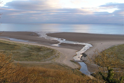
The major bay that lies below you is Oxwich Bay (picture, from Great Tor), and the dark headland which jut out so dramatically into the channel is Oxwich Point. On that dark, wooded slope, you may be able to see that the rocks are dipping towards you. This will be especially clear if the tide is out. This shows that between there and the crest of Cefn Bryn where you are standing there must be a syncline. In fact, this syncline passes directly under Oxwich Bay and is responsible for bringing down soft Namurian rocks which the sea has preferentially eroded.
The fact that the rocks of Oxwich Point dip into the Bay explains the frequent landlips along this side of the Point. Large blocks of rock, especially when lubricated by rainfall and encouraged by cold weather, can slip into the bay, detaching at prominent vertical joint faces and sliding over planes of lubrication - probably along bedding planes where the rainwater finds it harder to percolate downwards, and therefore collects, raising the hydrostatic pressure. One such rockfall occurred just before Christmas 2009, probably on December 19 or 20, according to local news reports.
If you look at your map, you will see that the next major bay to the west is Port Eynon, and its similar shape reflects the fact that it is caused by another, parallel syncline, also with Namurian rocks in its core. That it is somewhat narrower reflects the greater tightness of the Port Eynon Syncline. The anticline which lies between these two synclines runs along the length of Oxwich point, whose prominence shows that ahy weakness due to this structure is far outweighed by that offered by the Namurian shales.
 Still further west from Port Eynon, the wild and remote cliffs which lead to Rhosili are formed exclusively of limestones dipping north into the Port Eynon Syncline. For this reason they are not significant from a structural point of view, although their grandeur is unrivalled and well worth the difficult walk. (See also Paviland Cave; Dr Buckland's scarlet woman).
For this reason, the most geologically revealing localities tend to occur in the bays of south-east Gower, which we shall visit on the next two tours. You can see from here the winding river that leads out into Three Cliffs Bay, and the three pyramidal peaks jutting out into the sand. But before we descend, we should examine the detailed geology of Cefn Bryn itself.
Cefn Bryn
Just below you, if you are standing by the lookout-pillar, is a small quarry. Examination of this will reveal some very coarse, rusty red sandstones. These are called the Brownstones, and they underlie the pebbly conglomerate at the very top of the Devonian succession. As has been mentioned, the pillar is built of this rock, and you can see more of it on the eastern end of the hill.
Look now to the north once again. You will see that the road coming from Cilibion takes advantage of a marked hollow in the side and crest of the ridge in order to cross it. Also, notice the tiny reservoir, just below you; it is surrounded by a fence and has a small brick building associated with it. This is built upon an eternal spring, once a holy well. Both the hollow and the spring are the result of the Cefn Bryn Thrust which here cuts across the anticline at a low angle.
You will remember that a thrust (or reverse fault) is formed when one mass of rock is pushed up over another. Also, because both the folds and reverse faults were formed by pressure from the south, fold-hinges and thrusts tend to lie parallel. This is what is happening here.
The thrust carries the Brownstones over what is now only a small sliver of rocks - Lower Limestone Shales - trapped on the southerly limb of the anticline just below the hinge. This has preserved them there, while everywhere else they have been removed: but they nevertheless occur in a hollow, and their impervious nature has led to the emergence of the spring.
You should now return to the car park, cross the road and take the well-worn track which leads away due north.
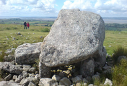 After a few hundred yards, you should notice a marshy area, and there may even be some bodies of standing water. This is the hollow where the thrust comes through, and the poor drainage is due to the presence of Lower Limestone Shales. Beyond this depression, the land rises slightly as you approach Arthur's Stone (picture).
This megalithic monument, probably a burial site and originally covered by an earth mound, consists of a huge capstone weighing 25 tonnes, part of which has split off and now lies alongside. Nine plinth-stones support the structure, which probably dates from the third millennium BC.
Geologically, this capstone is also interesting because for years it was casually assumed to consist of Devonian conglomerates like those comprising much of the hill itself. Detailed study has revealed, however, that it is of Namurian age - which brings us back to the parable of the 'Millstone Grit' (Tour 1) and the fact that in Gower the rocks deposited at this time were fine shales and mudstones rather than coarse sands and conglomerates.
Such conglomerates as those that were actually used as raw materials for the manufacture of millstones are common some 30 miles away on the northern edge of the coalfield, and are nowhere found in the peninsula. This block is therefore not in situ, but an erratic, brought here by the glaciers of the ice age. Prehistoric man appears to have capitalised upon this and used it in the manner you see.
It has long been a mystery how the large recumbent slab came to be split off from the main block. Recently, a book consisting of the assembled recollections of Gower people was compiled by the late J. Mansel Thomas under the title Yesterday's Gower (see reading list). In this volume, one Arthur Davies, carpenter, born in Landimore in 1884, expressed the belief that the deed was done by David Jones of Stonemill, who had it in mind to dress it and take it for use as a millstone. After performing the amputation, however, it is said that he found the block too heavy and had to abandon the attempt.
As many very old engravings of the stone seem to show this fallen slab, it seems very likely that this tale is apocryphal - though it certainly chimes in with what is now known as the true geological provenance of the capstone.
At Mumbles you saw what I described as two of the three vital ingredients of Gower geology: east-west folds and north-south faults. Here on Cefn Bryn, you have seen the third: east-west trending thrust-faults, of which the Cefn Bryn Thrust is a prime example. They run east-west in all cases, and in most of those they dip south - as here. However, at Caswell we will see one that actually dips northwards.
There is, perhaps, a fourth element to be remembered. That is the curious coincidence in Gower of major anticlines with hills and major synclines with valleys. It is also important to realise that this is due entirely to the nature of the succession here and does not betray any hard-and-fast geological law.
Read next tour...Caswell Bay