
Gower - A part of Earth History
Constant process, changing world
An introduction to the principles of geoscience
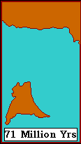
Over the apparently static face of the globe, the continents are in constant, inexorable motion, traversing immense distances over the great spans of geological time. So it should come as no surprise, when you look at the rocks of Gower, that they should have been deposited under deserts like the Sahara, or tropical swamps like the Amazon Basin or carbonate seas like those around the Bahamas. Because at these times the continental mass of which present-day Britain is a part was situated at, or even south of the equator for much of its history. Moreover, the tropical belts themselves may, in the past, have been much wider than they are today. All in all, the features of the Earth have not always been as they are now.
But in one other, very important respect, the world does not change, and the whole science of geology is founded upon this constancy. For though the continents may move about, and while mountains may rise and fall over immense spans of time, the processes that govern this state of flux do not themselves alter. They have operated for thousands of millions of years in the same manner as they did yesterday, will tomorrow, and for all eternity to come.
This means that if we want to use those rocks which are the deposits of ancient seas, rivers and deserts to try and learn about the world as it was, then our first job is to look at the deposits of modern seas, rivers and deserts, so that we can recognise their ancient equivalents. Then, when we spot the similarity between old sediments and new ones, we can infer that they were formed by similar agencies in similar environments. This is usually referred to as using the present as the 'key' to the past, and it is called "uniformitarianism". Because it is the source of all verifiability in geology, it is the ingredient that makes geology 'scientific'
Looking at rocks - succession and structure
 How does a geologist look at rocks? To understand what a cliff-face is trying to tell you, you must first identify two things about the rocks which compose it - the succession, and the structure.
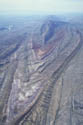
As time goes on, sediments build up in the sea or on land, and form a sedimentary pile. Obviously, the youngest sediments will be those on the top of the pile, and the pile will remain as it is unless Earth movements - such as those involved in the creation of mountains deform it. Now since mountain-building is something that happens when the drifting continents collide, the forces are compressional, and the rocks in the sedimentary pile are folded up. An example of this is provided by the Himalayas, formed when India crashed into Asia (right).
When rocks are deposited in the sedimentary pile, they are formed in horizontal layers, called beds or strata (s. stratum). These may be of various thicknesses, and may change in thickness from place to place, depending upon how much sediment was accumulating in each locality. Minor breaks in deposition, or changes in the type of sediment (mud to sand, sand to gravel, etc.) can cause the beds to become visibly separated from one another. The interface between one bed and another is called the bedding plane, and it represents an ancient depositional surface, such as the seabed.
 It is the bedding which enables us to see when rocks have been folded. Folds where the beds have been bent up into an arch are called anticlines. Downward-facing U-shaped folds are called synclines. When the mountains are uplifted and erosion planes off the tops of these folds (as in the picture, right), anticlines will have the oldest rocks at the centre, while synclines will have the youngest rocks at their cores.
The line that marks the core of the fold (as it is exposed in section along the ground) we shall call the hinge. The picture to the left shows an eroded anticline, whose hinge runs roughly in the direction of sight, through the highest point.
The rocks of Gower were affected by mountain building about 280 million years ago, and were strongly folded. This is why the bedding is no longer horizontal. But sometimes, the forces of deformation can be too great to be accommodated by this kind of plastic response, and the rocks break. Such breaks are called faults, and they take the form of deep fracture-planes, rather like a knife-cut through a cake.
- Stratigraphic Table showing all the main periods of Earth history, and their ages in years
By looking at the relationship between folds and faults, you can often tell which happened first. The fold may be faulted, or the fault folded. Of course, it follows that one set of faults may be offset by a later series, and folds may be re-folded to give some extremely complex patterns.
Between the coalfield and the Channel
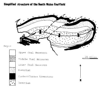 Everyone associates South Wales with coal, and it is mined here because of a massive syncline which dominates the geology north of Swansea. This trough of downwarped rocks preserves in its core rocks of the Upper Carboniferous; these are rich in beds of coal, and they have given the name to the period in which they were deposited.
Swansea sits on the southern limb of this syncline, so the rocks, therefore, dip to the north. As is the case with synclines, the older rocks crop out around the edges, and thus Gower rocks are those which are emerging from beneath the Coal Measures on this southerly limb.
But if this were the whole story, Gower would consist of northerly dipping strata becoming progressively older southwards. This is not so, because of a series of tight folds which begins on the peninsula and continues right under the Bristol Channel, as far as Devon (see North South section through Loughor Estuary, Gower, Bristol Channel and North Devon, below left).
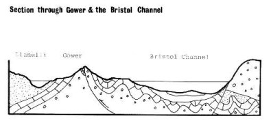 The hinges of these folds lie roughly east-west, just like the hinge of the coalfield itself, and this shows that the pressure during the mountain-building phase was coming from the south.
So Gower displays a transition-zone between the broad and open style of folding in the coalfield and the tight, narrow folds of the Bristol Channel. The section in Figure demonstrates this in simplified form. You will notice in this diagram that some of the shortening of the rocks has taken place along a fault-line, where one mass of rock has ridden up over another. This is a reverse fault, and there are many examples to be seen. They tend to run parallel with the hinges of the folds, as you might expect. They are called 'thrusts' in Gower, though this is not strictly correct usage of this term.
The story of the rocks
So far, we have been concerned with the structures that have been imposed upon the originally flat-lying rock-layers. Now we come to the interpretation of the sedimentary pile itself, which means deciding what sort of sediment each rock-type one was, and deducing from this the nature of the environment in which they were deposited. Conditions of deposition change through time, and this is what produces the characteristic sequence of rock types that we see in the peninsula
The oldest rocks cropping out on Gower represent the latter part of the Devonian period. They only occur in the cores of major anticlines. At this time, Gower lay in a region of sediment-laden rivers crossing a wide plain between mountains to the north and the sea, which at that time lay over Devon. These mountains were made of still older rocks, and their roots now form much of central and north Wales. The climate at this time was tropical, possibly monsoonal, and the choked streams carried sediment from the intense erosion taking place in the hills. Much coarse material was dropped en route, on the riverbanks and in the islands that split the streams into many minor channels. In Gower, we see pebbly rocks (conglomerates) at the top of the sequence overlying coarse sandstones.
- Gower Stratigraphy (what rocks are found, in what order, and formed in what environments).
The sea at this time began to rise relative to the land, and, as the Carboniferous Period began, the wide coastal plains of the Devonian were drowned. This was an example of a marine transgression, and on top of the continental conglomerates, marine shales (dark, fine-grained friable rocks) were laid down. Then, gradually, the water became clear; the amount of detritus reaching the area from the land was drastically reduced, and limestones began to form.
- PDF showing the broad history of Gower, as revealed by its sedimentary rocks
Britain was passing the equator now from south to north, and in the present-day ocean it is principally in such equatorial latitudes, in areas where sediment-supply is low, that limestones are being made. In the clear water calcium carbonate (lime) can precipitate, aided by the abundant life forms that secrete shells and skeletons. Without land-derived sediment to dilute them, these shells can form rocks in their own right, although many limestones are composed of microscopic particles of lime, called lime-mud.
The Carboniferous Limestone in Gower is about 800 metres thick, but traced northward, it can be seen to grow progressively thinner. Each individual unit becomes narrower, and there may also be some units missing. This suggests that the sea further north, being nearer to the land, was shallower and subsiding less quickly. Also, minor fluctuations of sea level could mean that in these shoreward areas, sedimentation could be interrupted more frequently, so resulting in omitted units.
There are many different units making up the Carboniferous Limestone, each with differing texture, thickness, fossil-assemblage, and so on. These differences were the result of subtle environmental changes, which we will touch on when we visit the localities. Not one of these little changes, however, was as severe as that which marked the complete end of limestone deposition in this part of the world.
During the Lower Carboniferous the forces which were eventually to fold and fault the rocks of Gower were beginning to flex the crust of the Earth upwards. This gave added impetus to erosion on the landmasses, which resulted in turn in river deltas swamping the limestone sea with detrital sediment. The water over Gower at this time was relatively deep, and fine shales with marine animals preserved in them were deposited. This time-period is called the Namurian.
The stage was now set for the deposition of the Coal Measures, which are the sediments of a widespread system of river-deltas close to sea level, upon which grew the lush forests of giant mosses, horsetails and ferns which eventually became coal. The Coal Measures therefore consist of sandstones, shales and coals arranged in repeated sequence, which tells of how forests grew, were buried by shales as the land subsided and then by sands as the rivers built out. On top of the river-sand, soil developed and eventually the forest became established all over again. So the cycle went on, bestowing upon Wales the mineral wealth which made it the birthplace of British industry.
This is the broad history of the rocks that make up Gower. After the Coal Measures were deposited, the period of mountain building folded and faulted them into their present arrangement. There are many names for this episode of deformation, but we shall call it the Hercynian. You may also see it called 'Armorican' or 'Variscan’ in other books.
After this orogeny, which took place about 280 million years ago. The rocks were eroded away as the great cycle of geological history repeated itself. More seas entered the area, more sediments were laid down over the eroded remnants of the Devonian and Carboniferous, and yet another orogeny (not so severe in Britain) folded the rocks. But no trace of these later rocks can be seen in Gower, except for one small patch of Triassic sediment in Port Eynon.
The last major episode to affect Gower was the Great Ice Age, which occupied the last 2 million years of Earth history. The climatic changes of this period put the finishing touches to the topography of the peninsula, at a time when man was first making an appearance upon it.