Cliffs of Slieve League
County Donegal, Ireland
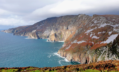
The cliffs at Slieve League are the highest sea cliffs in Ireland at 601m. They form part of the International Appalachian Trail, as they can be directly correlated with rocks found in Newfoundland, Canada.
 Slieve League comprises spectacular coastal cliff scenery, which is generally inaccessible, except from the viewing platform in the Bunglass public car park at the southern end of the cliffs. The cliffs have developed over the past 100,000 years, during and since the last ice age. The bedrock is Dalradian in age, with the primary rock type being thinly-bedded basal Slieve Tooey Quartzite Formation. Quartzites and gneisses of the Slieve League Formation occur at the base.
Slieve League is a megacliff, with steep slopes in quartzite, rising almost 590 m above the sea. There has been slumping on the seaward slope, and marine erosion has played only a small part in the shaping of the coastal profile, even though there is exposure to high-energy Atlantic waves.
There is also complex mass wasting with much of the steep (up to 60°) upper slopes covered with scree deposits. The scree slopes have residual buttresses of quartzite up to 12 m high that descend to vertical cliffs up to 200 m high, claimed locally to be the highest sea cliffs in Europe.
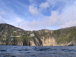
The coastal slope is dominantly formed of four separate corrie walls shaped by glacial and periglacial action, which were invaded by the sea in Holocene times and then basally trimmed. The steep slopes rise to One Man's Pass, a narrow ridge descending east of Slieve League, which is an arête with a north-facing corrie above Lough Agh. The remainder of the site is predominantly covered with blanket bog. In places, deep erosion channels in the peat expose the full peat profile.
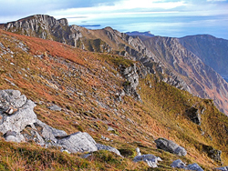 There are also two substantial outcrops of Carboniferous rocks along the southern edge of Slieve League summit and many loose boulders strewn around the summit plateau. The rocks are feldspathic sandstones and conglomerates, considered to be part of the Basal Clastics that form the base of the Lower Carboniferous throughout south Donegal. They are correlated with similar rocks to the east in the Largymore syncline, which are Ballyshannon Limestone Formation equivalents (Rinn Point Limestone Formation).
These Lower Carboniferous outcrops are outliers, resting unconformably on the Slieve Tooey Quartzite Formation. They occupy the highest topographical, and westernmost, position at which Carboniferous rocks occur in Donegal, suggesting that Carboniferous strata must have been deposited even farther west and have been lost to denudation. The total thickness of the exposed strata is less than 15m. Their preservation at the altitude of Slieve League summit is probably explained by differential uplift during the Palaeogene.
Slieve League is an important, internationally known, coastal feature and has been documented by the Geological Survey of Ireland as a County Geological Site which may be recommended as a Geological Natural Heritage Area (NHA). The area is already designated as an SAC and proposed NHA (000189), and landfall of the International Appalachian Trail (IAT) in Ireland has been designated as Slieve League.
Text: Sarah Gatley, Geological Survey of Ireland
(from unpublished Audit of Geological Heritage Sites in south Donegal, Geological Survey of Ireland 2014)
Related Links
Images (top to bottom):- The Slieve League cliffs, viewed from the viewing point to the south © Geological Survey of Ireland
- The Slieve League cliffs, viewed from the sea. © Geological Survey of Ireland
- The Slieve League cliffs © Jon Sullivan (Source:Wikimedia Commons) Public Domain
- Lower Carboniferous outcrop (foreground) on summit of Slieve League © Geological Survey of Ireland
![]()
October 13 - 21
Theme: 'Earth Science in our lives'