Slieve Gullion, Mountains of Mourne
County Armagh, Northern Ireland
Geologically Slieve Gullion and the encircling ‘ring dyke’ hills are considered to be the best example of a volcanic ring dyke system in the UK or Ireland. The complex attracts international research interest and has made contributions of world significance to scientific understanding of volcanicity.
 The oldest rocks in the area formed in an ancient ocean more than 400 million years ago during the Silurian period. Masses of molten granitic rock or magma, were later intruded into these rocks, which underlie Newry town and much of the Slieve Gullion area. These granites are some 390 million years old and date from a major period of mountain building in Ireland.
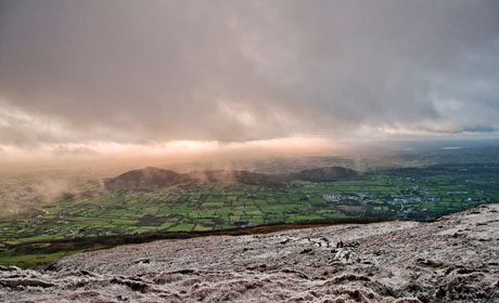
In the Tertiary period, commencing some 65 million years ago, the area once again became the centre of volcanic activity. Slieve Gullion is the eroded heart of a volcano active in the area some 60 million years ago. Volcanoes often develop an encircling ring fault or fracture around them and the Ring Dyke which gives the area its name is caused by magma, or molten rock, reaching the surface at several points in the fracture resulting in explosive eruptions of which there is still evidence today; the encircling ring dyke is some 11km in diameter and includes the hills of Crosslieve, Mullaghbane Mountain, Slievenacappel, Anglesey Mountain, Flagstaff and the Sugarloaf or Sturgan Mountain.

Volcanoes also erupted in the south of the area and the remains of volcanic necks can be found in the hills around Forkhill. Along the contact zone between the Silurian rocks and the Newry granite a roughly circular fracture developed into which was intruded a series of acidic lavas. These cooled to form very hard granophyre and felsite rocks - in fact two 'ring dykes'.
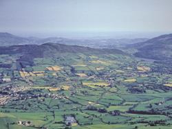
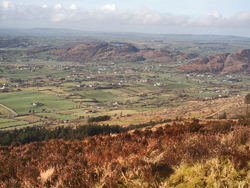 The ice age has also left its mark on the area. In more recent times the landscape has been shaped by the action of glaciers during successive Ice Ages. Glaciers exploited existing weaknesses in the rocks (faults and softer rocks) to erode deep valleys through the Ring of Gullion. The upstanding hills were glacially scoured leaving craggy outcrops (roches mountonnees), boulder strewn slopes and rocky ridges and hollows. The valley bottoms were in-filled with glacial deposits forming rounded drumlins, streamlined by the flowing ice.
The 'tail' of Slieve Gullion, which itself forms the 'crag', is seen at Dromintee, and is a ridge of boulder clay deposited in the wake of Slieve Gullion as it was overrun by ice moving from the north. To the south-east of Slieve Gullion is a ‘tail’ of glacial deposits, the Cashel Loughs lie in ice scoured basins, and the deep valley of Carlingford Lough is thought to have been formed by the ice.
The Mourne Cooley Gullion Geotourism project celebrates and promotes aspects of the Mourne-Cooley-Gullion region that make it special – its geology and the related fields of archaeology, mythology and heritage. Read more about the project here.
Text from the Ring of Gullion Area of Outstanding Natural Beauty
Related Links
- Uncovering the Past - The Geology and Archaeological Heritage of South East Ulster Area
- Camlough Mountain
- The Mourne Cooley Gullion Geotourism project
Map and photos credit: Ring of Gullion Area of Outstanding Natural Beauty
![]()
October 13 - 21
Theme: 'Earth Science in our lives'