The Needles
Isle of Wight, English Channel
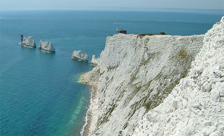
Popular with climbers and probably the most well known and visited spectacle on the Isle of Wight Island. The three sea stacks, which are composed of near vertically bedded Chalk are an extension of the cliffs on the south side of Alum Bay. The automated Needles Lighthouse at the western end of the stacks was built in 1859. The Chalk outcrop can be picked up again in Old Harry rocks to the south of Studland Bay in Dorset.

Research suggests that the Chalk outcrops of the Isle of Wight and Dorset were continuous and that the sea breached the hard Chalk ridge and eroded the much softer Tertiary clays and sands to the north. The breaching of the ridge probably occurred during the Pleistocene-Holocene period within the last 100,000 years.
Looking west today you need to imagine a continuous Chalk ridge running across to the Purbeck Hills of Dorset. Looking north across what is now the western Solent you would see a broad river valley of the historic Solent River.
Lulworth Cove, another of the 100 geosites, illustrates an early stage of the sea breaking through a hard ridge and eroding softer sediment behind it.
Text: Howard Colley
Grid Reference
- SZ 289848
- The Needles © Christophe Finot (Source Wikimedia Commons) Creative Commons Attribution-Share Alike 2.5 Generic License
- Clifftop and Rocks at the Needles © Christine Matthews (geograph.org.uk) Creative Commons Attribution-ShareAlike 2.0 license
![]()
October 13 - 21
Theme: 'Earth Science in our lives'