Parallel Roads of Glen Roy
Lochaber, Highlands, Scotland
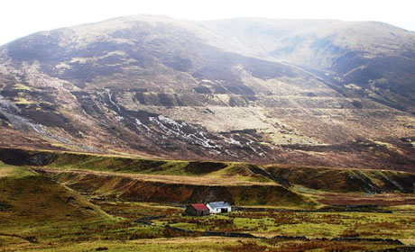
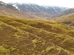
Glen Roy, near to the Great Glen, has various glacial features, but is undoubtedly most famous for its striking ‘roads’, mysterious parallel lines that are traced along the sides of Glen Gloy, Glen Roy and Glen Spean.
Glacial Lake shorelines

These ‘roads’, best seen on the sides of Glen Roy, are the remnant shorelines of a glacial lake that existed in the glen during the last phase of glacial activity (the Loch Lomond Stadial).
There are three levels of parallel ‘roads’ in the glen, all indicating different lake levels. These features are unique in Britain for their excellent preservation, and for the fact that they are partly cut into the bedrock.
Following the end of the last ice age during the Late Devensian (approximately 13,000 years ago), there was a cold spell known as the Loch Lomond Stadial (approximately 11,000 to 10,000 years ago). During this time, glaciers readvanced through the Highlands. At Glen Roy, the glaciers advancing from the south and west dammed a glacial lake in the valley.
The lake existed long enough to form shorelines high on the slopes of the valley. The partial incision into the bedrock is thought to have resulted from frost action caused by the arctic climatic conditions, although this is only at localities where the bedrock is flaggy, schistose or already partly weathered. The advance and retreat of the glacier front has formed three levels of parallel roads: 250m, 261m and 325m above OD. The outlet for the lake lay to the northeast.
Other landforms
Other important glacial landforms exist in Glen Roy, formed during the Late Devensian ice age. These include the deposition of moraines, outwash fans, erratics and the occurrence of landslips. It is also thought that earthquake activity accompanied the retreat of the Loch Lomond Readvance.
Early study of the Roads
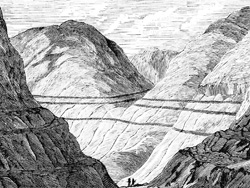
The enigmatic ‘Roads’ generated great controversy during the 19th century and became internationally famous.
The features were the subject of the most substantial piece of fieldwork that Charles Darwin undertook upon returning from his voyage on the Beagle, at a time when he was establishing himself as a geologist.
Darwin’s Theory
Darwin theorised that they were raised beaches, or shorelines made by the sea, and that the landmass then bulged up raising these beaches to their present height. However he was proved wrong when Louis Agassiz proposed an alternative explanation of the ‘Roads’, in terms of vanished glaciers.
Earlier Theories
There have been many theories for the lines, from ‘hunting roads’ for the Celtic Warrior Finbar to one road for travelling up the glen, another for coming down and another for driving cattle! However by the early 1800’s the ‘Roads’ began to attract serious scientific study although there were different ideas as to whether they were formed by human action or they were shorelines of some lost loch. In particular Thomas Telford, the famous Scottish canal and road builder thought that they had been constructed by human endeavour, presumably whilst he was working on the nearby Caledonian Canal. However the theory that they had been created by water became accepted as being the most likely. The problem was how had the water been able to create the shore lines.
The Evidence
 Darwin was sure that sea levels had fluctuated and was convinced that he would discover marine shell remains, but despite much searching he failed to find any.
However he still produced a paper, that as a recently accepted member, he presented to the Royal Society in 1839. It was maybe because of the status of being accepted into the Royal Society, especially at the young age of thirty, that caused Darwin to agonise over his ‘great blunder’ for so long before accepting Agassiz’s theory.
In 1840 Louis Agassiz made a visit to London and Glasgow and subsequently to the Highlands where he examined evidence of glaciation. Although many geologists were aware of a theory of ice covering much of the world, this was previously unknown and almost incomprehensible to the British public at the time.
Upon examining Glen Roy, Agassiz proposed that there had been a glacier in Glen Roy cutting off the normal drainage system. The water within the glens normal run off would, he proposed, have been trapped within the glen and impounded as a lake which would have filled until it reached a level at which it could escape.
The Stand Off
Darwin stubbornly refused to accept the new ‘ice’ theory for twenty years. During this period various well known geologists visited Glen Roy and refined Agassiz theory. In 1861 Jamieson used new theories on glaciation, the idea that the ice flowed as a viscous fluid, and together with evidence of a previously unnoticed col at the height of the second ‘road’ wrote the whole story which is still accepted today.
He could now explain the movement of glaciers which would have advanced into the glen, cutting off lower locations where the water could escape, forcing the lake level to rise to the next available crest over which it could escape. For the intervening period whilst the glacier moved slowly forwards the water level would remain static and that wave action would have, over time, cut a recess or shore line. A similar process would have occurred in reverse as the glacier retreated reinforcing the shoreline which, at least twice, had been submerged for some time.
In 1863 Darwin finally, although reluctantly, accepted that it must have been glaciation which created the ‘parallel roads’. However, by that time he was deep into the controversy about the origin of species and no doubt had enough to worry about without holding out about a theory that had become his ‘great blunder’ as he called it.
Text courtesy of Stephen Beard, Lochaber Geopark and ScottishGeology.com
Related Links
Nearby Geosites
Images (top to bottom)
- Glen Roy Credit: Lochaber Geopark.
- Snow on the 'roads' courtesy of Stephen Beard, Lochaber Geopark
- 1876 Illustration from Popular Science Monthly (Source Wikisource.org)
- Parallel Roads © Richard Webb (Source Geograph.org.uk) Creative Commons Attribution-ShareAlike 2.0 license.
![]()
October 13 - 21
Theme: 'Earth Science in our lives'