
Rhosili
 Rhosili is an isolated and lonely peninsular community, stuck out into the teeth of the fierce winds that blow straight in off the Atlantic: bending, stunting and killing any tree which tries to grow there.
To get to Rhosili, turn off the A 4118 at Scurlage and follow the B 4247 until you can go no further. The road that winds down through the village ends at the CAR PARK, where you will also find a shop, a filling station, a public house and numerous tea-rooms - of which you will be very grateful on a windy day.
Before leaving your car, please remember that the cliffs here have proved themselves lethal, and they continue to do so with gruesome regularity. This is usually the result of visitors, unaware of the potential dangers, treating these treacherous knife-edges with insufficient respect.
The excursion described does not involve going either on to Rhosili Down (the hill dominating the bay) or across on to Worm's Head. An opportunity to do these things should not, however, be passed over if you feel up to it.
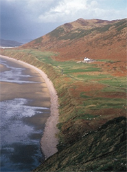
(Picture above right) - Rhosili from the Outer head of the Worm, showing Rhosili Down rising to almost 100m behind the village, which sits on the 70m (200 foot) wave cut platform
If you wish to cross the causeway at low tide, it is advisable to ask the coastguard in the house at the bottom end of the car park, just beyond the public conveniences. He will give you precise information about the tides. To be cut off on the Worm either means twelve hours of boredom or else a brief but exciting ride in an RAF helicopter - an experience not worth the embarrassment.
To the foot of the Down
 Walk back through the village, passing the church, and take the track leading to the bottom of the hill. Examine the scenery as you go; the Down runs the length of much of the bay, and its westward scarp is controlled by a north-south fault.
At the base of this long hill you will notice a narrow strip of land with a single farmhouse. Despite what you may think after seeing Pobbles, and despite what you may read elsewhere, this is NOT a raised beach. It is, in fact, a solifluction bench, formed by the sludging of large quantities of surface material down the scarp at the end of the Ice Age. This formed an apron, which the sea has now truncated at the head of the beach, where there is a low cliff of loose material.
As you approach the hill, you will notice that, to get to the small quarries, you must traverse a very damp and boggy area. The reason for this will be plain when you inspect the rocks in the first quarry. These contorted strata, dipping at about 70 degrees to the south, are alternating limestones and shales belonging to the Lower Limestone Shales. They have not, however, given rise to very much of a gully, because their width of outcrop has been greatly attenuated.
 At this point, an east-west thrust (the Port Eynon Thrust), running along the northern side of the Port Eynon Syncline has thrown the hard Devonian rocks against the overlying shales with such force that the softer formation has become plastic and flowed away from the regions of greatest stress. This non-uniform response is called "incompetent" behaviour. The reduction of outcrop-width, which has suppressed the usual geomorphological response of the presence of this unit, has been the result.
A walk to the next quarry will reward you with the sight of the Devonian, looking rather like the examples beside the telephone box at Penmaen (Tour 4). Fossil-hunters may, before they return to the village, care to take advantage of the rare exposure of the Lower Limestone Shales to search for the brachiopod Camarotoechia.
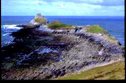
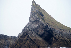
Picture (above left) - the Outer head and Devil's Bridge (natural arch) from the seaward end of Middle Head
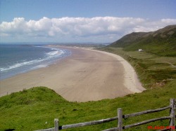
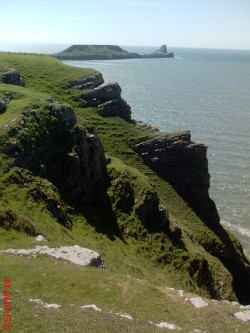
 Look now towards the village and Worm's Head (picture). The gently shelving plateau upon which the settlement stands is a beautiful example of the 200 foot wave-cut platform, as is the Inner Head of the Worm itself. The cliffs just below the village are probably in shadow as you look at them, but if you can detect the bedding, you may be able to make out that they are dipping away from you. The dip is similar to that in the quarries behind you, and this indicates that the syncline passes somewhere to the south of the settlement, or possibly, underneath
Look at the sketch-map provided. This shows the syncline passing more or less down the centre of the promontory, and emerging from it at its extreme tip. Bearing in mind that, at Port Eynon, this syncline is responsible for the presence of a bay, we have here a perfect example of the point made in Tour 2 ("Looking south").
The Port-Eynon Syncline (picture) is plunging to the east. The picture shows the view of the cliffs eastward from Rhosili. You can see how the dip increases in the distance, showing that the hinge of the syncline is near the photographer's feet at Rhosili, but moves inland relative to the southern coast the further east it goes towards Port Eynon, with the rocks of Port Eynon Point in the steep, southern limb. The Knave (picture, below) is near Port Eynon, and shows the steep northerly dip clearly.)
 Because of its eastward plunge, the hinge of the fold is at a lower topographic level at Port-Eynon than here at Rhosili. The effect of this is to bring the soft Namurian strata down to sea level at the former place, while here that formation has been entirely eroded away, and the Carboniferous Limestone is at sea level instead. Just as Oxwich Point, with its anticline running along its length, is more resistant to erosion than the Namurian shales preserved in The Oxwich Syncline, so here the emergence of the Lower Limestone Shales and the Port Eynon Thrust (at the base of the Down) has given rise to more rapid erosion than is seen as a result of the syncline's presence in the Carboniferous Limestone. And because of the differing hardnesses of limestone and overlying shale, the Port Eynon Syncline emerges at a bay at one end and a promontory at the other.
To Kitchen Corner
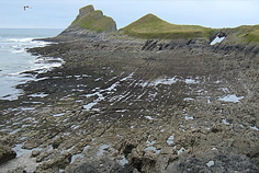
Walk back through the village, pass the Worm's Head Hotel and follow the path to Kitchen Corner, noticing en route the gradual decrease of dip in the limestones as you get closer to the axis of the syncline (picture above). When you reach the extreme end of the promontory, you might care to scramble as far as you can down the path leading to the little house which sits just underneath the cliffs. When you are almost at the gate to this building, look back to the cliffs behind you, and you will see the Port-Eynon Syncline emerging from the rock face, the strata to the north dipping south, and those to the south dipping north.
Return now over the knife-edge and take the low path which skirts the edge of the grassy slope above the rocks. At the location indicated in the sketch-map, you will find (if the tide is not in) another boat-shaped pericline, like the one at West Cross (Tour 1, stop 2).
This is the neighbouring fold to the Port Eynon Syncline, and is called the Worm's Head Anticline. The rocks of the Worm itself are dipping south quite steeply, and they are formed in the southern limb of this structure. A cross-section of this area is given in the PDF downloadable below, to help you grasp its overall construction.
- PDF showing the structure of Rhosili in TS and 3D projection
Conclusion
Here at Rhosili, all the elements of Gower geology come together in magnificent style. There are east-west trending folds with attendant parallel thrust-faults, and there are north-south faults, like the one controlling the western scarp of Rhosili Down. This hill serves to remind us of the way in which Devonian rocks form high ground in the cores of major anticlines, while the differing expressions of the Port~Eynon Syncline brings out the unique concordance which major downfolds also bear with valleys.
 Nevertheless, the eastward plunge of this fold serves to indicate that this is no hard-and-fast law of the science, merely the coincidence of structure and stratigraphy.
This has been the last of the field excursions, whose purpose has been to set forth the fundamental components of Gower geology. In the section which follows, some isolated sites and incidental matters are considered which it is hoped will be of interest to the geologically minded.
There are, of course, many unanswered questions: and for every one that is eventually resolved, another two appear to take its place. That is the nature of science. But those answers which the science of nature provides will continue to form part of the grand design that pervades and unifies the structure of this country.
In days gone by, sheep were set to graze on Worm's Head. It was believed by the owners of the Penrice Estate - for whose table these animals were destined - that their meat tasted sweeter than any other lamb. But it was also noticed by the estate's tenant farmers that sheep that had once been grazed on the Inner Head, if brought over again, would always try to make their way back to the Worm - many dying in the attempt.
The Shipway, as it is known, between the Head and the mainland, is a treacherous strait. Please take care and always check with the Coastguard before attemting a crossing.