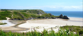
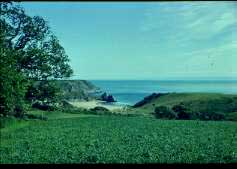
This must surely be one of the most beautiful bays in Britain (see pictures below). It has a wide mouth into which the massive form of Three Cliffs Rock juts from the eastern shore. This is an example of a natural arch, for there is a long, dripping tunnel through which one can walk quite easily at low tide.
The rock diverts the river (Penard Pill, which already curves around the storm-beach in a beautiful, wide arc) before it runs into the Bristol Channel. It also serves to divide the larger Three Cliffs Bay from Pobbles Bay to the east. Bathing is quite popular at this small and inviting inlet, though in the larger bay the currents can be treacherous and very strong.
There are many ways of approaching this beach, but for our purposes (and for the convenience of drivers) we shall enter it from Penmaen. The road from Swansea rises out of Parkmill, clears the tunnel of trees and climbs further until reaching the brow of the hill by a church and a small green on the right-hand side. Here, just after a very nasty left-hand bend, there is a fork turning leading away to the right of the church.
Here you should find adequate PARKING SPACE. If you overshoot, however, do not despair - and on no account attempt to stop, turn around or reverse! If you follow the main road a little way, you will come eventually to a collection of houses – the village of Penmaen. Turn right here, and this road will bring you back behind the church.
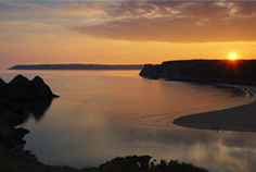 (Picture right - Three Cliffs at sunset). Looking West from above Pobbles. Great Tor is the farthest headland visible; Pyramid Rock the nearer. The Hill is of course Gower's backbone, Cefn Bryn (Devonian).
Having parked your car, return to the main road on foot, noting by the telephone box an outcrop of Devonian conglomerates. If you examine the surfaces of some of these joints closely, you may notice polishing and parallel scratches. These are slickensides, recording movement along the Cefn Bryn Thrust. Note that you are standing at the other end of Talbot's Road (Tour 2), which runs the length of Cefn Bryn.
Also, before descending to the bay, give a thought to the phenomenon of jointing. Joints are cracks in rocks along which no movement has taken place, and they tend to form by the setting up of stress-patterns during earth movements. We noticed the intensity of jointing in the Caninia Oolite at Caswell, in Tour 3.
From what I have just said, it should be clear that these 'joints' that display slickensiding are no longer true joints, since movement has occurred. But what else can we call them? They hardly merit the name of fault. This is one of those cases where the transitions of nature create problems for the need, in science, for precise terms. We shall say more about joints and stress-fields later.
Lastly, and as an aside, may I ask that, if you detect slickensides, that you do not remove them. Many people come to the science via a passion for hoarding, but it is a passion most geologists quickly grow out of, and I urge you to start now. Take photographs instead, and make sketches in a field notebook together with all your written observations, recording sizes and scales by means of recognisable objects in the field of view. This is a good deal more useful, scientific and considerate than hacking off great chunks, only to get fed up with carrying them later and hurling them into a ditch.
Across the road there is a narrow lane. Follow it for a little way until you come to a junction. Turn right, down a lane that takes you over the brow of the hill to a steep incline and a commanding view of Three Cliffs Bay.
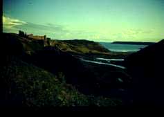 (Picture right - Three Cliffs from Parkmill, showing Oxwich Point and Penard Castle)
You will notice that the boulders which strew the hillside to your left are of the Devonian conglomerate which you saw recently by the telephone box. The lane bends east below a weatherboard shack perched on the hillside. There is a path here, which takes you directly down into the narrow valley. You should not be surprised to see this narrow gorge, because the rocks here are on the southern limb of the Cefn Bryn Anticline, and are younging to the south. The valley is therefore cut along the outcrop of the Lower Limestone Shales, just like the Cheriton Valley we saw from Cefn Bryn (Tour 2).
On the other side of the valley are Penmaen Burrows, a region of the 200-foot wave-cut platform covered with old dunes of wind-blown sand, mostly colonised by bracken. You will see similar dunes on the other side of the main valley, around Penard Castle (picture above). Indeed, these 'burrows' are found in many areas of coastal Gower, and they are rather interesting.
Investigation of the dirt-bands which represent 'fossil' soil-horizons low down in these dunes has revealed that they were probably built up in the late Mediaeval period. Apparently, a number of very severe winters assailed Gower at this time, and it has long been traditional that Penard Castle was destroyed in one night by a ferocious storm that swamped it with sand. Naturally, there is a (not very remarkable) fairy-story associated with this event.
It is true that the castle was not occupied for long, and was already in a very ruinous state in the 17th Century: but the sand-encroachment was probably not quite as catastrophic as legend would have us believe. As A.G.Thompson put it in his book Gower Journey:
"With regard to the formation of these (burrows), the local legends are as extraordinary as the golfing stories told on the golf-links constructed on them".
Now walk down the hill, past the seaside shanties on your right and follow the path to the bay, keeping to the right of the stream. When you have gained the sand, walk around the dunes and stop at the point where the limestone first emerges from them, on the west side of the bay. (Please do not cross the dunes - the action of feet has destabilised them severely, and restoration-work is under way.)
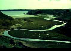 (Picture left) - Three Cliffs from Penard Castle (Penmaen Burrows). Note the meandering Penard Pill behind the storm beach, the salt marshes, and the much eroded dunes in the middle distance.
On the way, once you get a good view of the castle, notice that the rock upon which it is built is light grey in colour - it is limestone. But it faces Devonian rocks on the other side of the valley. This is graphic proof that faulting has shifted one side relative to the other. One would infer from this arrangement that there has been northward displacement of the eastern side, but note that when rocks are dipping, as they are here, vertical movements can also give rise to apparent lateral displacements, so one cannot be too sure. The fault itself runs very close to the scarp-face below the castle, passing out of the bay just west of Three Cliffs Rock.
You should now have reached the first outcrop on the seaward side of the dunes. The limestones here are dipping seaward at a fairly high angle (about 75 degrees from the horizontal) and they belong to the so-called 'z zone'. This refers to the coral Zaphrentis, but this locality is more remarkable for abundant remains of the brachiopod Chonetes.
Most people, until they come to geology, are unaware that there exist such creatures as brachiopods. They are sufficiently rare in today's oceans to have no common name in our language; except, that is, for 'lamp-shells', an obscure reference to Roman oil-lamps which can have little meaning to anyone who is not a classical scholar (or an ancient Roman). They are superficially like cockles and mussels, but this similarity is confined to their having two opposed, hinged shells (valves). So different are they internally, that they belong to an entirely different phylum of the animal Kingdom.
Brachiopods appeared at the beginning of the Cambrian Period, and so probably originated in the mysterious and distant Precambrian Era. All we can therefore say for certain is that brachiopods have been around for six hundred million years, and probably more.
Chonetes was a spiny, bottom-dwelling creature with a concavo-convex shell and it may well have been able to escape its predators by snapping its valves shut, so expelling a fierce jet of water. The clefts in this outcrop are due entirely to the popularity of this brachiopod with collectors, and are therefore another example of 'student erosion'. As a result, you may-need to be very lucky to see any really crowded bedding-planes.
 These Z-Zone limestones carry on for some way. As you walk down beside them, keep looking on the undersides of the beds where they appear weathered. Many finger-like projections will be seen to have been etched out strongly. These are fossil burrows, formed by worms passing through the sediment and back-filling their tunnels behind them: usually by a process of ingestion at the front and excretion at the back. The effect of this activity is often to sort the grains and pack them in a different way, which often leads to differences in the intensity of cementation at a later date. Thus it is that burrows may weather out, as erosion etches the different textures.
After a hundred yards or so, you will notice that the cliff recedes, forming a broad cleft with a sandy floor. This spot is often very popular with bathers for the shelter it affords. (In this way, the public often unwittingly selects sites of geological interest upon which to sit, but please remember that your interest in geology does not convey upon you any greater right to be there.)
At the back of this cleft, the beds appear to be disturbed. There is a small fold, which - at the sides of the gully - is sheared off. This may remind you of the Caswell Thrust, and with good reason, for this is also a thrust. But notice - this one dips seaward.
Now turn your back upon the gully and look over to the opposite side of the bay. Can you see where the thrust appears on that side? Our observations would suggest that (from the juxtaposition of limestone and Devonian conglomerates near the castle) the east side of the valley has moved north relative to the west, so look a little further up the bay. You will find that the evidence does not disprove this theory, but since the thrust dips in the same direction as the beds, the displacement could still be produced by vertical movement along the fault.
On the west side, however, the thrust brings on the dolomites which, at Caswell, we called the Laminosa Dolomite. Here the dolomitisation has been much less intense and they pass up quickly into a thick formation of light grey Caninia Oolite. If you climb onto the top of the low cliff here, you will be able to see the texture of the unit, which is characterised by alternate zones of light and darker-grey oolite, each with pronounced cross-bedding. This is a feature formed by ripples and dunes which, in this case, moved to and fro under a tidal regime, so making ripples which faced alternately one way, then the other.
This is a characteristic feature of oolitic sands, which, as we observed at Caswell, occur in the extreme shallows where wave-influence is strong. The colour-banding of light and dark is due to differing degrees of sediment-purity; the darker type having more lime-mud between the grains. You may see fragments of the darker limestone as large pebbles, reworked and reincorporated within the lighter. Currents ripped up the underlying formation and deposited fragments of it as shoals of very high-energy, clean-washed ooliths migrated across the barrier bar.
Note that cross-bedding (illustrated in the PDF) may be used to tell which way is 'up' in a strange succession. A geological mapper is always keen to get evidence of the younging direction, and the cross-bed is one very important piece of evidence. The rule to follow is that cross-beds are concave in the direction of the original bed-top.
If you now follow the Caninia Oolite, you will come to yet another recess in the cliff near where the bay opens out westwards, in the direction of Great Tor (pictured here from the Oxwich side). This locality also attracts bathers, usually the modest kind, shedding or climbing back into their clothes. It has been excavated along a distinctive suite of thinly bedded limestones and shales, known to you as the Caswell Bay Mudstones. We shall now look at these beds in a little more detail, and see if we can deduce from them something of the conditions under which they formed.
(Incidentally, in other books and guides, you may see this unit referred to under a variety of names. For example, it has been known as the 'lagoon phase' - a name for which there is some justification - and also as the 'Modiola phase', after the bivalve Modiola which it is supposed to contain, but doesn't! (Geologists are always changing names of rock units, but understanding principles is more important than remembering the names for things, so don’t worry.)
Look first of all at the upper surface of the Caninia Oolite, together with Figure 18). At Caswell, you remember, your attention was drawn to the hummocky surface upon which the mudstone was deposited. Here, it is much more freshly preserved, and if you examine the line of contact between the two units, you will see that the overlying bed fills in the hollows, proving that they were there prior to deposition.
But no bed of sediment naturally forms an upper surface like this. How, then, did it come about? If you look at limestones that are being eroded today, by the sea or by the rain, you will notice that the rock is dissolved very irregularly, forming clefts and pinnacles. Some of you may be familiar with the grikes and clints of limestone pavements. Differential dissolution like this is usually detecting changes in the rock texture, especially degree of cementation - and in the case of grikes and clints, it is accentuating joint-patterns along which permeability is greater.
Weathered limestone-surfaces are called karsts, and the hummocks and hollows which characterize them vary in size from a few inches to thousands of feet.
So the top surface of the Caninia Oolite is a form of karst, hut it was one which was formed during a regression of the sea in Carboniferous time. From detailed studies of the hollows, it has been possible to draw close analogies between this fossil karst-surface and the karsts which form today beneath scrubby vegetation in a region of South Africa; the implication being that each of these ancient depressions may have once contained the roots and soil-ball of some Carboniferous bush.
As further evidence of this, you may notice covering the surface in small patches, a dark brown porcellanous 'armour-plating', less than two centimetres thick. This is called calcrete, and under the microscope it reveals structures which form around roots in modern-day calcretes.
So here is evidence that there was an interruption (hiatus) in sedimentation. The sea retreated, leaving the oolitic sands exposed as new land. Vegetation grew, and this, together with rainwater, created the karst. Beneath this new land area, a lens of fresh water developed, pushing back the marine groundwaters and giving rise to dolomitisation in the mixed zone - hence the Laminosa Dolomite.
When the sea had withdrawn, it established a new shoreline somewhere to the south, and slowly it began to work its way back again. You can see where normal sedimentation took over, at the top of the Caswell Bay Mudstone. But the narrow mudstone unit itself records the gradual covering of the newly-emergent land with deposits of increasingly deep, sheltered water, probably protected from the open sea by a barrier of sediment running parallel to the shore. Conditions are very likely to have been highly saline (due to intense evaporation) and the biota was therefore restricted. For this reason, fossils are scarce in this horizon.
What became of the actual soil upon which the plants grew? If you look closely at the Caninia surface, especially where it emerges from beneath its overlying deposits, you may be able to pick out a reddish, sandy horizon of irregular thickness. This is all that remains of it.
Three Cliffs Bay is a beautiful place, and deserves a long stay. You may wish to walk around the Great Tor to Oxwich if the tide is low enough, noting on the way the pronounced fault (complete with calcite spar infilling) up against the Tor in the corner of the bay. Great Tor owes its existence to two parallel faults, each defining one of its sides.
If you wish to cross the river, you can easily wade and jump it close to the sea's edge. Note that the flow is broken into many shifting streams, which split and re-join around temporary islands. These are the characteristics of a braided stream, and it was by such rivers that, in the coastal deserts of the Devonian, the sandstones and conglomerates of Cefn Bryn and other Gower hills were probably laid down. If the river (Penard Pill) appears too daunting, you may also cross it further upstream by a set of stepping-stones, though this will be something of a walk (about a mile there and back).
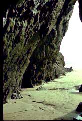
The prominent joints which give Three Cliffs Rock its pyramidal outline also control the position and shape of the passage beneath it (picture). As has been mentioned, joints commonly form in response to stress-patterns set up in the rock during earth movements, and in such cases a conjugate set may be created, which means a pattern of cracks symmetrically disposed about the stress-vector.
PDF showing the relationship between joints and stress, and comparing the theory with the joint patterns at Pyramid Rock
A classic example of such a set can be seen from the seaward side of the rock. Remember that the direction of compression (the stress-vector) was from the south, forming east-west folds. The compression was therefore parallel to the angle of maximum dip now seen and you can see that the dominant diagonal joints are symmetrically disposed about this line.
In the far corner of Pobbles Bay, you may notice a level bench, at about the 7 or 8 metres above the present beach, and cut into the cliff. Several large boulders of a type of conglomerate known as a breccia are resting upon it (breccia is a conglomerate whose pebbles are angular). These have fallen from the cliff-top, where you can see more of the same material, adhering precariously.
This level bench is the remnant of a raised beach, cut into the cliff during a recent glacial epoch when the sea was eight metres higher than at present. The breccia is called "head", and it occurs more or less all over the Gower coast. It, too, dates from the Ice Age, and was formed by a process involving freeze-thaw action and soil-flow (solifluction).
If you have left you car at Penmaen, then you had better go back the way you came. If, however, you are not constrained by a car, try climbing up the path to the top of the eastern side of the bay, and walking east along the track to Penard Village. Here you can catch a bus to Swansea, or visit the shop. A somewhat easier route leaves Pobbles via the back of the bay, and takes you to Southgate (the village adjacent to Penard) past the golf course. At the end of this path there is a bus stop, and a shop.
Alternatively, you could walk to Parkmill by climbing the dunes behind Pebbles and skirting the western side of the links. This route enables you to inspect the castle before descending to Parkmill. A mile or so along the road in the direction of Swansea will bring you to Stonemill (as not many people now know it is called). Just across the river, not far from an old school building (now a Field Study Centre) there is a large pub (The Gower Inn) with CAR PARKS and a beer garden.
Read next tour... Rhosili