After Laurentia had converged with Avalonia and Baltica, bringing the two halves of the UK together in the Caledonian Orogeny, Gondwana continued to drift north.
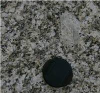
Granite from Luxulyan quarry,
part of the Cornubian batholith
By the late Palaeozoic (250 million years ago), the continents had converged to form a supercontinent, called Pangea. The collisions which brought this about are known as the Variscan (sometimes Hercynian or Armorican) orogeny, which took place over about 100 million years. The main effects on the UK took place in the late Carboniferous to early Permian (about 290 million years ago).
The event created the Variscan mountain belt, which includes the mountains of Portugal and western Spain, southwest Ireland, Cornwall, Devon, Pembrokeshire, the Gower Peninsula and the Vale of Glamorgan. The main trend of the fold axes is E-W, indicating a N-S collision.
Image courtesy of Gordon Neighbour.
Evidence in the UK
The effects are seen in Devon and Cornwall, South Wales, and northern England, and in Devonian & Carboniferous rocks.
The orogeny resulted in intrusions and volcanics in Devon and Cornwall – including the granite intrusions that underlie the SW peninsular of the UK (known as the ‘Cornubian batholith’). The batholith is exposed at the surface at several places including Dartmoor and Bodmin Moor.
There was intense folding, such as that at Hartland Quay, North Devon; and Millook Haven in Cornwall; along with folding of the South Wales coal fields.
Image courtesy of Gordon Neighbour.
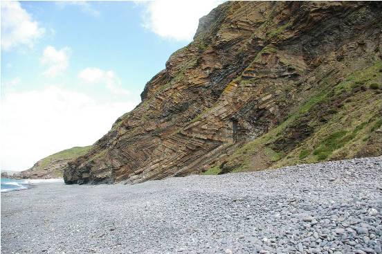
Folds at Millock Haven, Cornwall
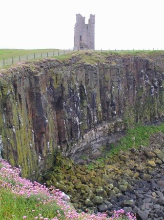
Dunstanburgh Castle and Whin Sill, Northumberland
Image © Nigel Chadwick
Also in Cornwall, Variscan activity is associated with faulting, in particular the development of the Lizard Complex. The outcrop pattern of these very complicated rocks, which include ophiolites, is mainly the result of Carboniferous thrust faulting.
The orogeny caused the intrusion of the Whin Sill (Co Durham and Northumberland). Whin Sill is the name of a group of dolerite intrusions which reaches a maximum thickness of about 70 metres in the Northern Pennines. The high cliff line formed by the sill is seen at High Force Waterfall in Teesdale, Bamburgh Castle, Lindisfarne Castle and stretches of Hadrian’s Wall.