 Four Swansea brothers criss-crossed the geological world of the 1840s, mixing with great names in famous places, says Martin Laverty
It is 100 years since Alfred Russel Wallace, theoretician of evolution and biogeography and sometime land surveyor and engineer in West Glamorgan, died. Influential names Hooker and Lyell brought him to fame in 1858; but their earlier appreciation of a Swansea family responsible for pioneering practical geology in Britain, India, and Borneo, had no such effect for the brothers Williams, who have sunk into obscurity.
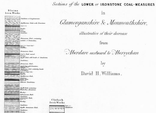
Above: Vertical Section Sheet 9 (Extract) Sections of the Lower and Iron-stone Coal Measures of Glamorganshire and Monmouthshire by David H Williams
PRACTICAL MEN
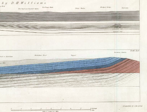
David Williams (1783-1856), a labourer turned land and mineral surveyor, did some work with one of his sons for the great William Edmond Logan (managing a copper works, he mapped the coal around Swansea in search of fuel). This son, David Hiram Williams (1812-1848) has appeared in these pages before (July 2009, Geoscientist 19.7) as part of Nina Morgan’s series Distant Thunder. As the first assistant hired, in 1839, by Henry De la Beche's Ordnance Geological Survey to add to Logan's base, he specialised in preparing measured vertical (above) and horizontal (below) sections, mapping, especially, Coal Measures from Pembrokeshire, into Somerset and right up to Flintshire, before finishing at Coalbrookdale.
Below: Coal, Limestone, and Old Red Sandstone in the Forest of Dean (Extract from Horizontal Section Sheet 15), by D H Williams.
To his bosses, De la Beche and John Phillips, he was as valuable as Andrew Crombie Ramsay, and he weaned Henry William Bristow from university into practice. In 1845 the Survey became a civilian rather than military body; Ramsay was promoted (both he and Bristow went on to head the Survey), and De la Beche arranged for Williams to start, in Bengal, what would become the Indian Geological Survey.
Early in 1846, he wrote to Ramsay:
“The Island of Ceylon is a pleasant looking place, but Aden is horrible, it is all on volcanic formation mostly scoria I found some Green Sand fossils in a limestone passing through Egypt Malta appears to be oolitic, and Gibraltar, Mountain Limestone.”
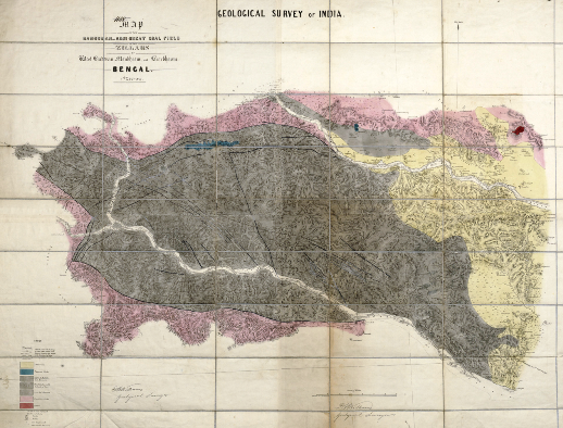 Left: Map Of The Damoodah And Adji Great Coal Field In The Zillahs Of West Burdwan, Monbhoom, and Beerbhoom, Bengal by David Hiram Williams 1847.
Within six months he had reconnoitred 420 miles west of Calcutta; by 1848 he had mapped – topographically as well as geologically - a coalfield “with more reserves than Britain or America”, and begun calculations on the economics of building Indian ironworks for the coming railway age. He reported the Glossopteris flora, and later noted a distinctive:
“conglomerate of quartz and granite boulders some of them 11 feet in diameter, and lots of them longer than an elephant's head!!”
...identified a decade later as glacial: both, a century later, key evidence for plate tectonics, and even later, for the 'Snowball Earth' hypothesis. However, after introducing the Geological Survey's first (and by then ex-) palaeobotanist, Joseph Hooker, to India early in 1848, he concluded:
“Geologising in India is dull & torpid with nothing to be seen but Coal Measures and crystalline rocks. No fossils of any kind to be found but the impressions of coal plants”
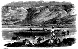
Right:Williams's entourage crossing the Sone River in 1848 (from Hooker's Himalayan Journals, 1854). In the dry season, shallow rivers were a huge problem for river transport, but simplified river crossing under the limestone escarpment of the Kymore Hills. The wet season was desk-bound.
Hooker wrote of their transport:
“Our elephant was an excellent one, when he did not take obstinate fits, and so docile as to pick up pieces of stone if desired and with a jerk of his trunk and throw them over his head for the rider to catch, thus saving the trouble of dismounting. This is geologizing in true oriental style, and no traveller's tale, I assure you.”
before he ”Bade adieu to Mr. Williams … whom I hoped to see [again]”.
Sadly this reunion never came about because, as Lyell wrote to his own father about Hooker in January, 1849:
“no less than 4 of his intimate friends had died, and among them Mr Williams the geologist. … I pointed out that every one of five geologists whom [the East India Company] had sent out [to India] had been cut off in the prime of life, for want of aid in assistants, elephants, steamers, &c., which alone could enable them safely and effectively to perform their mission; and I protested, with De la Beche, against the best of his practical men (the said Williams) being sent out on a forlorn hope. He has done his business, poor fellow, well, put them in the way of working rich mines of coal, and is now left like his predecessors to die in the ditch...”
After almost three years of uninterrupted good health, D H Williams was:
“unfortunately caught by a branch of a tree and fell from his Elephant, and was for some time suspended by the heels - he subsequently fell also from some rocks and hurt his knee and jungle fever followed...”.
Thus came Williams’s somewhat undignified demise. His name has remained in print ever since 1845, when the Geological Survey first published acknowledgements on its maps and sections and in its Memoirs. The latest Swansea sheet to bear his name was issued just a year short of the bicentenary of his birth.
ACQUAINTED WITH COAL
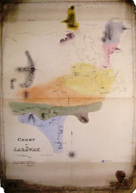 A delicate water-colour manuscript 'Chart of Sarawak' (left) drawn by another ‘Hiram Williams’, was donated to the Society by the Admiralty in 1846. This Hiram (1816-1872) started out as a Land and Mineral Surveyor with his eldest brother, William (1811-1886); like Wallace, their work included tithe mapping. Late in1844, the Admiralty instructed Captain Bethune RN to proceed to Borneo and:
“take … [someone] ... who is well acquainted with coal, and can therefore form a correct opinion as to any in the neighbourhood of the spots you visit, both as to its probable extent and its fitness for use in steam vessels...”
Left: Chart of Sarawak by Hiram Williams, Mineral Surveyor, 1846. – One inch to the mile. The only known copy, in the Society’s archives, measures 1.5m x 1.2m [Ref: LDGSL/728]. (As noted in last November's Geoscientist, maps have not always been stored in optimal conditions!). Rivers, topography, and toponyms were extracted by the Admiralty (at the same scale) for the first version of their Chart 1822. How many other such charts derive from a geological survey?
Bethune left alone, but Edward Forbes (Geological Survey palaeontologist from 1844) asked De la Beche to identify that ‘someone’. Hiram soon arrived in the idiosyncratic settlement of Sarawak on the island of Borneo, where James Brooke was the British ruler of his own, independent state. He examined coal in Labuan and made a plan for exploiting it in Brunei; but the bulk of his time was spent surveying Sarawak on foot and by boat. Brooke facilitated this work, as well as at least one rice-wine-fuelled party, where his group:
“finished the evening by treating the Dyaks with a dance in their own style; Williams keeping the [chief] in perfect terror by threatening his bare feet with a tremendous pair of high-lows.”
Hiram also drew the scenery (below). His drawings, lithographed in London, probably sold as individual prints, but mainly survive, with his map, illustrating three books and regularly copied ever since.
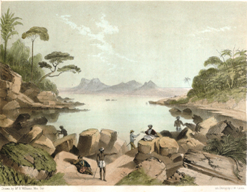 Right:‘Drawn by Mr H Williams Min Sur’. Hiram’s drawings, lithographed in London, sold as individual prints, but mainly survive as the illustrations of three books.
Hiram settled in London. For a short time in 1851 he was in a ‘Civil and Mineral Engineering, Surveying, &c’ Partnership with Ernest Noel (well-connected, later an MP and FGS for 82 years when he died in 1931), before taking the position of Secretary to a number of (mainly) mining companies from an office in the City between 1851 and 1862. He became managing partner of a coal mine near Rotherham in 1861 but the deaths of six men, tipped out of their descending bucket, in 1863 led to his spending his declining years as a gentleman farmer in Oswestry.
SURVEYORS, MANAGERS
In 1816, William, David Hiram, and Hiram Williams were baptised with yet another brother, Lewis (1814-1873). Lewis created a special feeder for an iron works, was praised in court for his use of models to explain the deleterious effects of patching (opencast mining) on nearby underground workings, and helped the Survey without being actually employed by it. He and William briefly opened their own coal mine, but drainage problems brought debt and legal wrangles that lasted for years. For a time he managed a mine in the Forest of Dean (with Hiram acting as Secretary), then moved to Cardiff and died managing the Caerphilly Colliery. William, the least travelled but longest lived brother, died an engineer in Swansea.
This remarkable geological dynasty did not last. Hiram took two wives but fathered no children; David left four daughters; William's son Frederick was recorded as ‘geologist’, but only in 1851; Lewis' s namesake son continued the trait, working as a mining engineer in Bridgend; but he, and William, died in 1886.