.jpg?h=435&w=352&la=en) John Underhill, Peter Styles, Kosmas Pavlopoulos and George Apostolopoulos* report on the latest progress towards discovering Odysseus’s true home.
John Underhill, Peter Styles, Kosmas Pavlopoulos and George Apostolopoulos* report on the latest progress towards discovering Odysseus’s true home.
If you are writing a very long and intricate historical narrative, it is hard enough to have to invent characters and their exploits without also having to invent the world they inhabit. It is far easier, indeed, to present the geography of the real world as their stage. Perhaps therefore we should not be surprised if Homer’s descriptions of the places that Odysseus visits on his arduous travels, and of his homeland, the fabled ‘rocky Ithaca’ - relate to landscapes still recognisable today.
Fig. 1: Location of the major geological and tectonic features associated with Kefalonia and the surrounding islands (from Valkaniotis 2014).
But although both Iliad and Odyssey present many geographical clues, they have been hotly debated for decades. Heinrich Schliemann, the German businessman turned archaeologist, ardently believed that Homer was describing real places. He effectively used the Iliad as his Baedeker, claiming that he had discovered Troy. While, over the centuries, many suggestions as to the true location of Homeric Ithaca have been made - including some hundreds of miles away in the Balkans. Various Peloponnese islands - Ithaki, Lefkada, Kefalonia – as well as Sicily and even the Spanish Coast near Cadiz, have all been proposed.
Kefalonia (or parts of it) have figured strongly, with authors often selecting the northern peninsula, near the modern village of Fiskardo, as their preference - including recently Brckovic (Odysseus’s Ithaca - The Discovery 2001) and Goekoop (Where on Earth is Ithaca? 2010). Others have pointed to SE Kefalonia, where Mycenaean tombs have been discovered near Tzanata.
This is how Homer describes Odysseus’s home (emphases by James Diggle):
εἴµ' Ὀδυσεὺς Λαερτιάδης, ὃς πᾶσι δόλοισιν
ἀνθρώποισι µέλω, καί µευ κλέος οὐρανὸν ἵκει.
ναιετάω δ' Ἰθάκην ἐυδείελον: ἐν δ' ὄρος αὐτῇ
Νήριτον εἰνοσίφυλλον, ἀριπρεπές: ἀµφὶ δὲ νῆσοι
πολλαὶ ναιετάουσι µάλα σχεδὸν ἀλλήλῃσι,
∆ουλίχιόν τε Σάµη τε καὶ ὑλήεσσα Ζάκυνθος.
αὐτὴ δὲ χθαµαλὴ πανυπερτάτη εἰν ἁλὶ κεῖται
πρὸς ζόφον, αἱ δέ τ' ἄνευθε πρὸς ἠῶ τ' ἠέλιόν τε,
I am Odysseus, Laertes’ son, world-famed
For stratagems: my name has reached the heavens.
Bright Ithaca is my home: it has a mountain,
Leaf-quivering Neriton, far visible.
Around are many islands, close to each other,
Doulichion and Same and wooded Zacynthos.
Ithaca itself lies low, furthest to sea
Towards dusk; the rest, apart, face dawn and sun.
(Odyssey 9.19-26, Transl. J Diggle)
.jpg?h=310&w=352&la=en) The fourth word in the penultimate line - πανυπερτάτη (panhupertate), meaning ‘furthest of all’ - clearly indicates that Ithaca is the most westerly of the islands in that region. Some other translations render it thus: ‘last of all in the sea to westward’ (W H D Rouse); ‘nearer the west than its neighbours’ (T E Lawrence); ‘farthest out to sea, rearing into the western dusk’ (Robert Fagles).
The fourth word in the penultimate line - πανυπερτάτη (panhupertate), meaning ‘furthest of all’ - clearly indicates that Ithaca is the most westerly of the islands in that region. Some other translations render it thus: ‘last of all in the sea to westward’ (W H D Rouse); ‘nearer the west than its neighbours’ (T E Lawrence); ‘farthest out to sea, rearing into the western dusk’ (Robert Fagles).
Fig. 2: Conventionally accepted configuration of the plate boundaries near Kefalonia and important localities (from Briole et al 2015).
Modern-day Ithaki (unsurprisingly) claims to be ancient Ithaca. But it is manifestly not the ‘furthest west’; that honour belongs to Kefalonia and, particularly, its western peninsula Paliki, which is also much less mountainous than Ithaki (i.e., ‘lies low’ - Figure 1).
Bittlestone
In 2003, the former classical scholar, economist and business adviser Robert Bittlestone, together with James Diggle (Professor of Greek and Latin, Cambridge University) and Professor John Underhill (Chief Scientist, Heriot-Watt University, Edinburgh) first noted that Paliki, the western peninsula of Kefalonia mentioned above, would fit Homer’s description had it once been an island, geographically separated from the rest of Kefalonia. It would then be west-facing (‘towards dusk’), while the surrounding islands face east (‘towards dawn’), as well as the ‘furthest out to sea’, and ‘low-lying’.
 In their book 2005 Odysseus Unbound: The Search for Homer’s Ithaca (Cambridge UP) they also highlighted descriptions of Kefalonia by Greek writer Strabo, in his 17-volume Geography. That seminal tome was composed sometime in the first two decades of the Christian (Roman) era and describes the known world, employing an astute combination of personal observation and travellers’ reports.
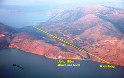
Fig. 3: Aerial View looking NE across Thinia over the buried site where ‘Strabo’s Channel’ would have run. The valley is 6kms in length, up to 2km wide and rises to a height of c.180m at its saddle and watershed.
Describing Kefalonia, Strabo wrote:
Cephallenia lies opposite Acarnania, at a distance of about fifty stadia from Leucatas (some say forty), and about one hundred and eighty from Chelonatas. It has a perimeter of about three hundred stadia, is long, extending towards Eurus [east or south-east], and is mountainous. The largest mountain upon it is Aenus, whereon is the temple of Zeus Aenesius; and where the island is narrowest it forms an isthmus so low-lying that it is often submerged from sea to sea. Both Paleis and Kranioi are on the gulf near the narrows.
 This 2000-year-old description contains some surprisingly precise and accurate measurements, which inspire confidence in the veracity of Strabo’s reference to a low-lying narrow isthmus near Paleis and Kranioi that is often (but by implication, not always) covered by the sea from end to end.
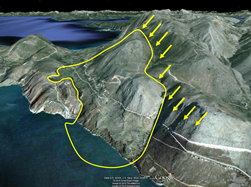
Fig. 4: Outline of the massive landslide which occupies the southern end of the Thinia valley over riding the underlying limestones.
The location of the two settlements is not in doubt, since their remains are still visible on Paliki and near Argostoli today. Strabo therefore provides an independent reference to a marine channel, in just the right place to make an island of the Paliki peninsula – a place now occupied by the isthmus, and specifically, the valley of Thinia. Bittlestone et al. also identified a series of locations on Paliki as candidates for key Ithaca sites, mentioned in the Odyssey, that seemed to fit Homer’s descriptions. But the hypothesis faced a major obstacle. Today, the valley lies well above sea-level (up to 180m) - which inevitably prompted some scepticism (Figure 3).
Fugro
 Their work led to Fugro’s supporting research to resolve this conundrum by deploying geotechnical teams and sponsoring a NERC PhD project by Dr Kirsten Hunter (2013), which enabled key geological and geophysical tests to put flesh on the theory’s bones.
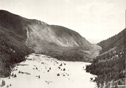
Fig. 5: Catastrophic co-seismic collapse and rotation of a hillside at Hebgen Lake, Montana, USA created by the 1959, Hebgen (Yellowstone) 7.5 Earthquake.
These investgations showed evidence of marine sediments on the coast and near offshore in the last Post-Glacial period, while seismic analysis demonstrated that the Thinia valley had indeed been a marine channel in the Quaternary, some 400,000 years ago.
More recently, significant evidence has emerged that the southern end of the Thinia valley became blocked by a massive translational and rotational mass movement of a single block measuring c. 4km by 1km - most likely following a major tectonic event - with smaller landslides infilling the valley’s northern end. Such a large rotational slump (Figure 4) may well account for the 180m rise in elevation we see today.
Fig. 6: The 7.8 Magnitude, 2016 Kaikoura earthquake caused major landslides blocking valleys and damming lakes very much in the manner suggested for the Thinia valley.
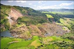 Analogous situations are indeed common in seismically active regions. A notable example is the collapse and rotational translation of a hillside at Hebgen Lake in Montana, USA that dammed outflow and created ‘Quake Lake’ (Figure 5). The shape, scale and form of the feature is precisely analogous to the situation in the Thinia valley - right down to a toe of displaced material, running up the hillside to the right, and the damming of a river to create a lake. Figure 6 shows a mass movement feature of similar scale, created by the Christchurch Earthquake (7.8ML) in 2016 on the New Zealand Alpine Fault - an area of similar tectonic complexity to the Kefalonian region.
The two key questions are, therefore:
- Did sea level rise sufficiently after the last Ice Age to flood the Thinia valley again - and, critically, when? Was it before the Late Bronze Age, c.3200 years ago, usually considered the time of Odysseus?
- When did the tectonic event - and its resultant huge translational slump - occur? Was this after the Late Bronze Age? Perhaps even, given Strabo’s description, within the last 2000 years?
If the answer to both these questions is ‘yes’ then the case for Paliki as Homer’s Ithaca becomes compelling. But first, a slight digression.
Fig. 7: (Print issue only): TEM-derived and geophysical images of the Thinia valley revealing the presence of en-echelon features indicative of right lateral (dextral) shear through the area in the same orientation and sense as the Kefalonia Transform Fault. (For technical reasons this image cannot be reproduced online. Editor.)
Kefalonia transformed
.jpg?h=548&w=252&la=en) The current consensus is that the Kefalonia Transform Fault - the major tectonic boundary which shifts the Hellenic Arc Subduction Zone (African Plate beneath Aegean Plate) some 200km northwards until it is converted into the continental collision zone between the Apulian platform and NW Greece (Adriatic against Eurasian Plate) - lies west of Kefalonia. It is usually drawn thus - see Figures 1 and 2.
The current consensus is that the Kefalonia Transform Fault - the major tectonic boundary which shifts the Hellenic Arc Subduction Zone (African Plate beneath Aegean Plate) some 200km northwards until it is converted into the continental collision zone between the Apulian platform and NW Greece (Adriatic against Eurasian Plate) - lies west of Kefalonia. It is usually drawn thus - see Figures 1 and 2.
Fig. 8: Seismological Evidence from Briole et al (2015).
The Kefalonia Transform Fault probably eventually becomes the North Anatolian Fault - one of the major trans-continental fracture zones of the world, at least equivalent to the New Zealand Alpine Fault on which we have already seen huge disturbances and uplift. However, the largest Kefalonian (indeed the largest recorded Greek) earthquake event (M7.2, 1953) had its epicentre on Kefalonia, probably on the Ionian thrust, an oblique convergence with a left–lateral component (Figures 1 and 2).
The Odysseus Unbound team have recently (summer 2017) undertaken new surveys to compile new geophysical maps, integrating the data with earlier data from FUGRO, which was presented in Hunter (2013). The new gravity/magnetic/resistivity and geomorphological images of the Thinia valley and adjoining regions are shown in Figure 7, which shows LIDAR derived images of slope (a) and aspect (b) (Pavlopoulos 2017) and geophysical images of apparent resistivity (c) and magnetic anomaly (d) (Apostolopoulos 2017). All these images show sets of NNE-striking features along the southern Thinia valley, and also that these are segmented and offset to the NNW - indicative of right lateral (dextral) shear.
Figure 8 also shows that the Kefalonia Transform Fault is either distributed in deformation across the western part of Kefalonia, the Paliki peninsula, or even that it runs east of Paliki through the Thinia valley before skimming Lefkada.
The conspicuous topographic discontinuities seen in Figure 7 and, more significantly, the series of en echelon offset features, are exactly what we would expect if a significant amount of transcurrent dextral shear had taken place along a distributed major transform or transform-related boundary. It seems evident therefore that the KTF is not a single structure but a wide distributed zone as it crosses continental Kefalonia, including splays off the main structure.
This interpretation would define the Kefalonia Transform Fault as a major trans-continental shear zone akin to the Dead Sea Shear, the North Anatolian Fault, the San Andreas Fault and the New Zealand Alpine Fault, where enormous mass translations have significantly changed the topographic profile (Figure 6).
.jpg?h=181&w=251&la=en) Figure 9 confirms the importance of Kefalonian seismicity. The clustering analysis of earthquakes in the Aegean shows the very highest significance around Kefalonia. Figure 10 shows the concentration of significant geological disturbance on the Lixouri and Thinia peninsulas.
Figure 9 confirms the importance of Kefalonian seismicity. The clustering analysis of earthquakes in the Aegean shows the very highest significance around Kefalonia. Figure 10 shows the concentration of significant geological disturbance on the Lixouri and Thinia peninsulas.
Fig. 9: Clustering Analysis of Aegean Seismicity showing that the Kefalonia region has the highest significant clustering in the context of the extremely active regional seismic activity (from Weatherill and Burton 2009).
Intense deformation
There seems to be very strong evidence that the Thinia valley is the site of intense geological deformation and that significant major modification of the topographic profile is not implausible, even in the relatively short period since Homeric times.
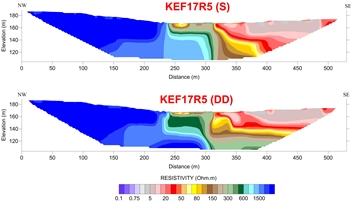
The elevation of over 100 metres along the postulated route of a marine channel across the isthmus separating Paliki from Kefalonia remains a problem for even a narrow seaway. However, recent electrical resistivity geophysical surveys in the southern region (Figure 11) show significant thicknesses of very poorly consolidated materials more than 60m thick, which extend even further (well below 120m). Further, a traverse across the frontal (toe) zone of the landslip material that covers the western hillside (Figures 12, 13) suggests that it may have infilled a deep, albeit possibly narrow, channel.
.jpg?h=461&w=350&la=en) So, let us return to our two key questions about timing and mechanism.
So, let us return to our two key questions about timing and mechanism.
Fig. 10: Field observations of geological effects triggered by the January–February 2014 Cephalonia (Ionian Sea, Greece) earthquakes from Valkaniotis et al (2014).
Sea level
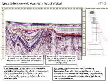
Previous offshore seismic interpretation (Hunter 2013) has demonstrated the presence of onlapping sediment fill, related to the last glacial lowstand (22,500 B.P.) when sea levels were c.125m lower than they are now. Figures 14 and 15 show this northwards-directed onlapping deposition, which records Late Quaternary and Holocene post-glacial transgression and infill.
But to show that the Thinia valley was marine during Homer’s time, we must demonstrate that seawater reached the head of the Gulf of Livadi more than 3200 years ago, and identify and date the subsequent landslide deposits that closed the channel and turned Paliki from an island into a peninsula.
Although biostratigraphic sampling of boreholes drilled in the Thinia valley demonstrate that there was a marine channel 400,000 BP, evidence of its continued existence within the past 5000 to 10,000 years BP is essential to make the case. We plan further onshore and offshore sampling and biostratigraphic and microfossil analysis to resolve this.
Closure
Fortunately, a relatively simple resolution is possible. There is what appears to be a historically recent settlement on the western (Paliki) side of the southern entrance to the Thinia valley, whose walls end abruptly at the edge of landslip material (Figure 12, foreground).
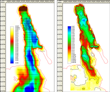
Fig. 11: Schlumberger (top) and Dipole-Dipole Electrical Resistivity surveys SE Thinia region clearly showing very low resistivity, i.e. poorly consolidated or water-saturated sediments with electrical resistivities as low as 5 ohm.m, juxtaposed against high resistivities of 1500 ohm.m characteristic of limestone. This indicates a significant geological discontinuity, perhaps a fault scarp, > 60m high (Apostolopoulos 2017). (Location of profile shown in Figs. 12 & 13.)
 The satellite image appears to show that the toe of this landslide overruns and covers the southern part of this settlement which, if this occurred in, say, the last 2000 years, would suggest that it happened during the last two millennia - and so provide a robust dating mechanism for establishing the chronology of the seismic and ground uplift event(s). We plan further high-resolution geophysical investigations in the Thinia valley, to determine firmly whether the landslide did indeed cover relatively recent walls, or other artefacts.
Evidence suggesting that these walls were simply built ‘up to’ landfill material would not invalidate the hypothesis, but would mean that other dating mechanisms would need to be considered. For example, a small palaeo-lake bed, (Lake Katochori), sits on top of the landslide material onlapping the rockfall debris - clearly indicating that it formed on top of the landslide, which had cut off an earlier stream. Sampling and dating the deepest lake bed material would offer an alternative ‘upper’ time constraint, since the existence of the lake was the basis for a later Venetian settlement.
Fig. 12: View looking west across Lake Katochori at the southern end of the Thinia Valley showing the triangular, wooded area(circled) where the toe of rockfall and landslide material covers the hillside on which apparently historically recent walls have been discovered.
Remains of apparent Bronze Age structures on Paliki suggest that the area was important at this time. Preliminary geophysical surveys have revealed sub-surface structures in some areas, suggesting construction activity in ancient times. Further detailed investigations are planned, to define the optimal sites where excavation might reveal the layout of buildings and valued possessions, aiding understanding of the relative sophistication of the civilisation on Paliki and whether it was Late Bronze Age (c.1200 BC), earlier, or later.
Conclusions
Geological investigations carried out after the recent major earthquake on Kefalonia (2014), together with our own geophysical surveys, provide new insights into the intriguing question as to whether Homer was describing the Paliki peninsula as the site of 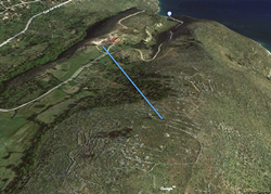 Odysseus’ Ithaca.
Fig. 13: Satellite image looking south (from Google Maps) showing a historically recent settlement apparently over-run by onlapping landslide material which would provide a means of determining the age of the major mass-wasting events which might have closed the marine channel. The location of the resistivity profile of Figure 11, KEF175R, is shown in blue.
It seems likely that the major plate boundary, the Kefalonia Transform Fault, which has traditionally been drawn as running west of Kefalonia, may be more diffuse, affect a wider region than previously envisaged, and be the ultimate driver for co-seismic landslides and rockfalls. Its immediate impact in the Thinia valley and Gulf of Livadi is to cause dextral fault offset seen on seismic data and topographic features. This is consistent with earthquake fault-plane solutions and the sense of movement along the major plate boundary between Europe and Africa.
Electrical resistivity data indicate great thicknesses (>60m) of poorly consolidated (landslide) material overlapping an archaeological site associated with wjat appears to be a relatively recent historic settlement, and may suggest that a deep channel (‘Strabo’s Channel’) once existed there.
 Further geophysical investigations should provide clues as to whether the landslide over-ran the settlement – strongly indicating a post-Homeric age for this intense geological and geomorphological activity and strengthening significantly the case for a narrow seaway separating Paliki from the rest of Kefalonia.
Fig. 14: W-E striking seismic section across the Gulf of Livadi showing the highly folded and deformed nature of the Neogene sedimentary units that lie unconformably below the Late Quaternary and Holocene cover Livadi (Hunter 2013).
Although much remains to be done, geological support for the intriguing possibility that the site of Homer’s Ithaca might eventually be reconciled with Homer’s geographical descriptions on the Paliki peninsula, is getting stronger. To be continued!
Acknowledgements
We acknowledge the contributions of the following to the most recent phase of scientific research and analysis conducted in and around the Thinia valley: Professors Kosmas Pavlopoulos, Paris-Sorbonne University Abu Dhabi, and George Apostolopoulos, National Technical University of Athens, and their very capable teams, who collected field and geoscientific data, performed comprehensive technical analyses, and created the graphics depicting their findings.
 Authors
Professor John Underhill is Chair of Exploration Geoscience & Chief Scientist, Heriot-Watt University, Edinburgh, Scotland. E: [email protected]. Peter Styles is Emeritus Professor in Applied and Environmental Geophysics at the University of Keele, Staffordshire, England. E: [email protected]. Kosmas Pavlopoulos is Professor of Geology-Geomorphology, Paris Sorbonne University Abu Dhabi. George Apostolopoulos is Professor at the National Technical University of Athens, School Of Mining And Metallurgical Engineering, Mining Engineering Section, Laboratory Of Applied Geophysics.
Fig. 15: Maps showing shape and form of unconformity beneath Late Quaternary and Holocene sediments (left) and thickness of sedimentary fill. Note pronounced right-lateral offset of main depocentres (near headland of Argostoli peninsula) taken as evidence for dextral strike-slip motion as part of distributed strain associated with the Kefalonia Transform Fault (Hunter, 2013).
Selected references & further reading
- Apostolopoulos, G., (2017), Technical report for Katochori in Kefalonia 2017, Unpublished report, National Technical University of Athens for the Odysseus Unbound Foundation, 50pp
- Bittlestone, R., (with Diggle, J., and Underhill, J.), (2005), Odysseus Unbound: The Search for Homer's Ithaca, Cambridge University Press., 405pp. See also the Project website.
- Briole, P., Elias, P., Parcharidis, I., Bignami, C., Benekos, G., Samsonov, S., Kyriakopoulos, C., Stramondo, S., Chamot-Rooke, N., Drakatou M.L., and Drakatos G., (2015), The seismic sequence of January–February 2014 at Cephalonia Island (Greece): constraints from SAR interferometry and GPS, Geophys. J. Int. (2015) 203, 1528–1540.
- Hunter, K.L., (2013), Evaluating the geological, geomorphic and geophysical evidence for the re-location of Odysseus' homeland, 'Ancient Ithaca’, Unpublished PhD Thesis, University of Edinburgh, 482pp.
- Nield, Ted 2007, Fair wind for Odysseus. Geoscientist 17.04, p11.
- Pavlopoulos, K., (2017), Katochori Geomorphological Survey, Unpublished report, Paris Sorbonne University Abu Dhabi for the Odysseus Unbound Foundation, 35pp.
- Underhill., J.R., (1989), Late Cenozoic deformation of the Hellenide foreland, western Greece, Geological Society of America Bulletin, 101, 5, 613-634
- Underhill, J.R. 2006. Quest for Ithaca. Geoscientist. 16 (9). pp. 4-29
- Underhill, J.R. 2008. Testing Classical Enigmas. Geoscientist, 18 (9), 20-27
- Underhill, J.R. 2009. Relocating Odysseus' Homeland. Nature Geoscience, 2, 455-458.
- Valkaniotis, S., Ganas, A., Papathanassiou, G. & Papanikolaou, M., (2014), Field observations of geological effects triggered by the January–February 2014 Cephalonia (Ionian Sea, Greece) earthquakes, Tectonophysics, 630, 150–157.
- Weatherill G., and Burton P. W., (2009), Delineation of shallow seismic source zones using K-means cluster analysis, with application to the Aegean region, Geophys. J. Int., 176, 565–588.