Lauren Ballarini* describes the water-management of a UK surface coal mine in a Special Area of Conservation.
Although deep-mined coal is a thing of the past in the UK, and geological attention tends to focus instead upon remediating its centuries-long legacy, opencast mining for coal still goes on, under strict environmental controls. As a recent Editorial pointed out (
Geoscientist 27.05 June 2017), it is unlikely that permission would ever be granted to opencast for coal in, for example, a National Park or under Chatsworth House, but given the proper safeguards it is still given. But can the public reply rely on the assurances of the miners? For it is also true that, in the past, many remediation promises have proved hollow – often in the area of hydrology and hydrogeology.
Things have come a long way since the era recalled in that editorial - but how far? We may, I think, be able to judge from my experience gained recently at an opencast mine in Leicestershire, just outside the village of Measham, exotically called Minorca (because it occupied the site of a former underground mine of that name).
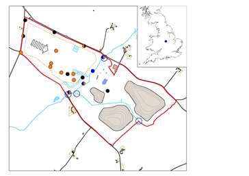
The question facing UK Coal (later UKCSMR) – and us at Wardell Armstrong – was this. Would it be feasible to operate a surface coal mine to extract remaining reserves, in the catchment of a Special Area of Conservation (SAC), without damaging it? This conundrum first arose in 1994. Initial geological information indicated that the site was favourable for economic opencasting (Figure 1, left.
Hi res version). However, the site was bisected north-south by a watercourse called the Gilwiskaw Brook.
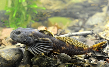
This, and a smaller unnamed tributary in the site’s eastern part, fed into the River Mease which, with its tributaries, constitutes an SAC, designated for its population of Spined Loach (
Cobitis taenia) and Bullhead (
Cottus gobio, image right). Since operating the surface mine would require dewatering – i.e., abstracting groundwater and discharging it – would we be able to balance the needs of both miners and environment?
What we found was that, by dint of careful operation and monitoring, the answer could indeed be yes. So how was it done?
Operation
In 1994, UK Coal began the long journey from resource modelling through to the reality of seeing the mine produce first coal in 2013. Geological investigations continued through 2006 and 2008, resulting in a resource estimate of 1.25Mt of coal from the 130-hectare site. Excavation - up to 53m deep - would occur to the west of the Gilwiskaw Brook. The eastern part, where Coal Measures occur at depth in a steeply dipping syncline and have been subject in the past to extensive deep mining, would be used for storing the overburden - up to 20m thick on the site’s south side, and consisting of a mixture of Triassic sediments, alluvial deposits and made ground.
Alluvial deposits occurred along the length of the Gilwiskaw Brook, changing from predominantly silty and sandy deposits in the north to clayey material with Triassic gravel and cobbles in the south. The Brook at one point cuts down into the Triassic, and where it exits the site, in a channel about three metres deep, Triassic strata lie exposed in the bed. Within the Minorca site, these Triassic strata were of the basal Moira Breccia Formation of the Sherwood Sandstone Group – one of Britain’s greatest aquifers - and consisted mostly of red marls with clay, gravel and sand.
The main target seams (called Main, Little Woodfield and Lower Main) lay amid grey shales and mudstones with thin coals. There were no significant sandstones to deal with; though in the northern portion of the excavation, old mine voids were encountered, generally at c. 10 – 15m below ground level (bgl).
Groundwater
So much for the solid geo
logy – but what about the groundwater? The water table in the alluvial deposits generally lay between 3.5 – 4.5m below ground level, and existed in continuity with the water flowing in Gilwsikaw Brook. Groundwater flow was, we found, strongly influenced by the stage of the Brook, and rainfall; though as a general rule, the alluvium received recharge from the Brook in the northern part of the site, and provided baseflow to it in the southern part.
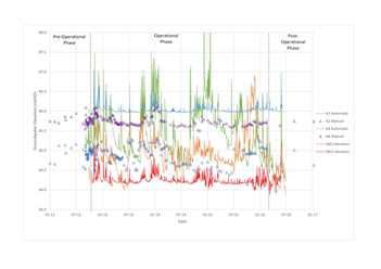
Figure 2, left: Groundwater elevations in the alluvials compared to surface water elevations in the Gilwiskaw Brook).
Hi res version
Groundwater in the Moira Breccia lay generally between 2.5m - 5.0m below ground level, and was also in some continuity with both the alluvium and the Brook itself
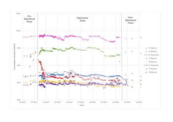 Figure 3, right:
 Groundwater elevations in the Moira Breccia.
Hi res version
Generally, groundwater flow within the Moira Breccia was directed towards the SE, controlled by the sub-horizontal dip of the strata, striking NW-SE.
Within the Coal Measures, groundwater (at between 9.5 and 20m down) was controlled largely by the old workings, though here too the general flow direction was south-eastwards. Regionally, as deep mining has ceased in the South Derbyshire Coalfield, groundwater levels have been rebounding (though there was no sign of this at Minorca). This means that generally, poorer quality, metal-rich, saline groundwater has of late been coming into contact with overlying aquifers.
Abstraction plan
The Environment Agency and Natural England were concerned about deteriorating water quality in the Gilwiskaw Brook. Additionally, because of the hydrogeological connection between the alluvium,Moira Breccia and surface water, they feared that dewatering the excavation could lead to the base flow reversing and the Gilwiskaw Brook being drained. Clearly, abstracted water from the site could not be allowed to pollute the River Mease, so it would have to be pumped to Water Treatment Areas (WTAs) for settlement and, if required, additional treatment, before being allowed into the Gilwiskaw Brook.
Figure 4: Groundwater elevations in the Coal Measures
Hi res version
During the planning process, Wardell Armstrong provided enough evidence (through groundwater and geochemical modelling) to satisfy both the Environment Agency and Natural England that neither scenario was likely, and that they could be avoided by careful monitoring and management of both groundwater and surface water at the site. In 2011, we developed an operational Water Management Plan (WMP) to allow this monitoring and management to be put into action at the site. This detailed the data relating to groundwater and surface water-levels, flow and quality that would be collected throughout the mine’s operation and restoration phases.
Flow-monitoring was needed to detect any impending reversal of groundwater flow, within the Moira Breccia or alluvium, well before it had time to affect the Gilwiskaw Brook. Quality monitoring was needed to give advance warning should the hydrochemistry of groundwater abstracted from the Coal Measures start to differ from the baseline in the geochemical model (and thus potentially negatively affect the quality of water in Gilwiskaw Brook when discharged).
Figures 5 & 6, right: Groundwater elevations in the Moira Breccia
Hi res version F5.
Hi res version F6
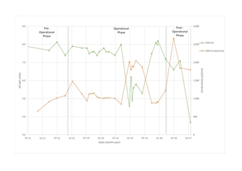
The Coal Authority worried that the Minorca pit could act as a sump for regionally rebounding deep groundwater, thus ‘sucking in’ poorer quality groundwater. Groundwater modelling, undertaken during planning, had suggested that this was unlikely; but just in case, two ‘sentient’ boreholes, CM2 and CM8, were installed on the western site boundary, equipped with continuous level, pH and conductivity meters, to provide ample warning of advancing poorer quality groundwater.
Data
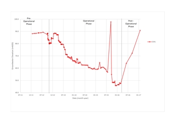
So, our modelling done, contingencies identified and with monitoring in place, UK Coal were ready to begin the operation. Groundwater level data from the Coal Measures clearly shows the start of dewatering, in July 2013, as levels begin to fall in the monitoring wells installed in the Coal Measures (Figure 4). Excavation progressed generally from west to east, and CM2 (on the western site boundary) first registered drawdown from resultant dewatering. As the excavation moved east, groundwater levels in this borehole began to recover, from November that same year.
Flow from the excavation was measured continuously, and found to be generally about 10 – 15 litres per second (L/s) - a combination of groundwater inflow and rainfall. Numerical models made during the planning phase had predicted groundwater flows of 5 – 10L/s, and with rainfall, of up to 20L/s on average. Occasionally, higher flow-rates (40 and 41L/s) were recorded; but these were all the result of particularly heavy rainfall (once, over 37mm of rain was recorded at the site in a single day!).
Groundwater levels in the Moira Breccia showed no change as a result of mining operations and, when compared to water levels in the alluvium and Gilwiskaw Brook, we detected no reversal of flow from the Brook to the alluvium. Alluvial deposit data showed that groundwater there was strongly influenced by rainfall. During the winter, the alluvium provided significant baseflow to the Brook along its entire length.
All these data on groundwater levels were collected and reviewed monthly, and supplied to the Environment Agency every quarter, enabling UK Coal to demonstrate that its activities were having no detrimental effect on surface water level or flow in the sensitive Gilwiskaw Brook.
Quality
So what of water quality? Fearing that fish in the brook might be harmed by green algae, an annual average water quality standard of 0.06 milligrams per litre (mg/l) of phosphate is applied for the Gilwiskaw Brook, lower than would be applied for other water bodies. However, in the vicinity of the site, before 2008, the Gilwiskaw Brook already recorded annual average phosphate content of approximately 15 – 20mg/l. This was coming mainly from a Water Treatment Works further upstream. The introduction of a phosphate-stripping unit at the works reduced phosphate levels to c. 0.5mg/l in 2009 – 2010 - which was better, but still too high.
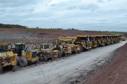
Image, left: Mining fleet. Red marls of the Moira Breccia overlying the Coal Measures clearly visible in background.
The possibility that phosphate might be present in the Coal Measure groundwater was a key concern for both the Environment Agency and Natural England – as were high chloride and metal loadings, particularly from old mineworkings and possible groundwater rebound, as mentioned above. Phosphate had not been detected in groundwater samples from the Coal Measures before operations began. However, when the site was operating, phosphate was detected in groundwater in the Coal Measures; but the annual average limit of 0.06mg/l was never exceeded, either there or in any discharges from abstracted groundwater from the sumps.
Comparing water-quality data upstream and downstream of the mine, we found that concentrations of phosphate in the Gilwiskaw Brook entering Minorca were now significantly greater than those leaving it: in other words, the site discharge had a positive effect on water quality in the Gilwiskaw Brook, by dilution.
Sump
By mid-2013, we were recording poorer quality groundwater in the excavation sump than in the surrounding Coal Measure boreholes (including in the sentient boreholes CM2 and CM8). Concentrations of chloride, sulphate and nickel were rising, while pH showed a corresponding fall. This suggested that poorer quality, deeper minewater was beginning to enter the excavation through the old mineworkings encountered, as well as by upflow through the base of the excavation.
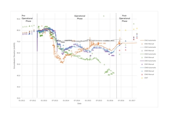
This trend continued throughout 2014 and 2015. Only in one borehole, CM4 to the north of the site, did we encounter any similar deterioration. At the end of 2014, with groundwater levels at c. 59.7m above ordnance datum (AOD), a drop in three pH units was recorded (from pH 8.0 to pH 5.0) in CM4 (Figures 5, 6). At the same time, we observed a spike in conductivity and an increase in nickel concentration.
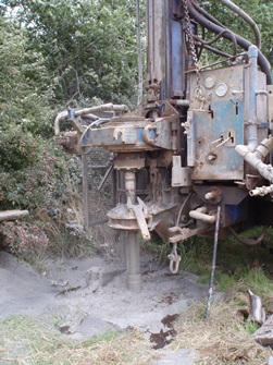
Image right: Drilling in pogress.
A review of the borehole log indicated that high inflows, possibly associated with old mineworkings, were encountered at 61m AOD. We went on detecting poorer quality water until September 2015 when, with groundwater levels now at 54m AOD, quality improved - as suddenly as it had deteriorated. We concluded that, as dewatering reduced the water column in this borehole, poorer quality water (associated with previously unknown old mineworkings) began to dominate; but that as groundwater level was drawn below those workings, their influence ceased.
The quality of abstracted groundwater from sump to discharge into the Gilwiskaw Brook was carefully monitored in the various WTAs along its flow-path. Additional measures, such as dilution with cleaner water and installation of straw bales into the WTAs, were implemented - with the aim of reducing the influence of poorer quality water on the overall discharge, as well as retaining suspended solids. Monitoring of discharges and of the brook showed that despite slight downstream increases in boron, dissolved iron, sodium and conductivity (compared to upstream), these were insignificant when compared to background water quality.
Successful
Minorca operated successfully, without detriment to the Gilwiskaw Brook, until March 2016 when mining ceased. In May 2016, the discharge permits were surrendered. Restoration had been undertaken progressively, and was complete by November 2016. Wardell Armstrong were asked by UKCSMR to review post-operational water monitoring data, and liaise with the Environment Agency to confirm that there had been no long-term effect on groundwater, and that conditions were returning to pre-operational ones.
The data reviewed and analysed during operation showed that there had been no reduction in groundwater quality either in the alluvium, the Moira Breccia or the Coal Measures - except for the short-term deterioration detected in CM4. When the short-term nature of this trend and its link to old mineworkings were made, we predicted that when groundwater rebound occurred, the same trend would be seen once again.
Sure enough, as groundwater in CM4 passed up through the relevant elevations, pH fell and conductivity rose once more. With time, concentrations are expected to return to pre-operational conditions as the groundwater in the Coal Measures reaches pre-operational levels.
Nearly a year since entering the post-operational phase, groundwater levels in the Coal Measures have rebounded generally to within one metre of where they were before we started. Groundwater level monitoring continues (albeit at a much reduced frequency). Once Coal Measure groundwater reaches pre-operational levels, monitoring will cease.
Through the three years of Minorca’s operational life, and into its restoration period, flows and quality of ground and surface waters were measured both manually and automatically. The experience has proved, to my satisfaction at least, that it can indeed be feasible to operate a surface mine in an environmentally sensitive site, as long as whoever undertakes the task is prepared for the arduous business of monitoring the water environment fully.
* Lauren Ballarini is Associate Director, Wardell Armstrong LLP. E:
[email protected]