Jones, D & McCormick, T., Strengthening Geoscience in Developing Nations. Geoscientist 30 (5), 14-17, 2020
https://doi.org/doi: 10.1144/geosci2020-087, Download the pdf here
Darren Jones and Tim McCormick on how the BGS is partnering with geoscience organisations across the world
 In the UK, we are fortunate to have access to world leading geoscience research institutions. But many international students from low-income countries return home with a toolbox full of geological skills and knowledge, only to find themselves frustrated with a lack of investment in geoscience in their home country due either to economic or political factors. For many years, the British Geological Survey (BGS) has been working with counterpart surveys to help mitigate these impacts; most recently as part of a multi-million pound project called Partnerships for Development (P4D) funded by the UK Department for International Development (DFID).
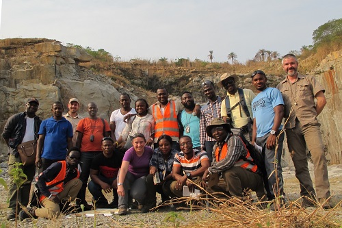
Above: BGS geologists with partners from the National Minerals Agency, Petroleum Directorate and Fourah Bay College during fieldwork training in Sierra Leone
Natural resources
The extractives industry still provides the largest demand for geoscientists across the world. Utilisation of natural resources offers an opportunity for developing nations to enhance their economic development, with demand unquestionably high; the population in sub-Saharan Africa, for example, is expected to double over the next 30 years.
Many factors, whether the passage of time, lack of necessary investment or staff retention, have led to some low-income countries losing geological knowledge and data, or failing to keep up with the latest developments and techniques in the Earth sciences. For any country to successfully exploit natural resources in an environmentally acceptable manner, a geologically skilled workforce and a detailed understanding of its own geological make-up is key. Geological data is the essential foundation on which natural resources are governed. It is paramount, then, that those government organisations responsible have the capability to acquire, manage and understand the data.
Partnerships
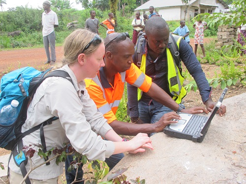 Right: BGS working with the National Minerals Agency in Sierra Leone providing training using the BGS Sigma digital field mapping kit
Throughout its history, BGS has had a global presence, collecting geological data across the world. Since 2017, we have been providing a development role in strengthening geoscience through partnerships with geological institutions across Africa and Asia; specifically in Ghana, Kenya, Sierra Leone, the Kyrgyz Republic and Tajikistan. These partnerships form part of the P4D project, which aims at leveraging skills and expertise from UK public sector institutions and supplying them to public sector counterparts in developing countries. In our case, we are working with countries which have prioritised developing the extractives sector of their economy and identified the need to build capacity and skills in acquiring and managing geological data.
The project has involved providing in-country geological training, IT/database system development, strengthening facilities like laboratories, engagement on developing natural resource policy, and supporting acquisition of new geological data to underpin strong extractive governance.
BGS also collaborates with other international aid donors and the World Bank. In Sierra Leone we have been tailoring our training to align with a recent World Bank-funded country-wide airborne magnetic survey and a hydrocarbon licencing round. We are collaborating on best practice procedures in laboratory facilities and on developing national geological and geochemical surveys. Facilitating the transfer of geological knowledge to these geoscientists supports them in developing an impartial understanding of their natural resources and promoting their development.
In the Kyrgyz Republic our activities have focused on developing a digital workflow for the delivery of key geological datasets required for mineral exploration and the assessment of landslide risk in mineral rich areas. Peer-to-peer working alongside more formal training is helping to develop a co-designed workflow that will be sustainable into the future.
Data Management
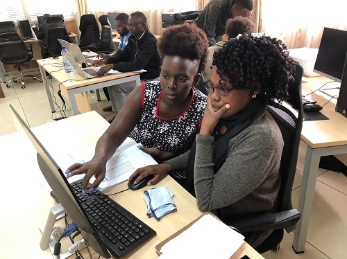 Left: Computer training in the Kenyan Directorate of Geological Surveys (DGS) Geo Data Centre
Another key aspect of our work is capacity building in geo-data management. In Kenya and elsewhere, we have been working on constructing a national ‘geo-data centre’; an integrated database of geoscience data and information which stores and delivers the national geoscience knowledge base. Such data centres are essential for demonstrating a country’s resource potential.
In many cases, the partner organisation is starting from a low-level of capacity in digital data management, and may not have a central data repository or networked computers. In these cases, part of our work is to help the partner install the IT infrastructure required to implement the geo-data centre. In some cases, capital funding for the hardware is provided by the national government of the country where we are working, or an international donor like the World Bank, and BGS advises on procurement. As well as obvious things like servers, PCs, and software (both open source and, where necessary, commercial) BGS advises on network setup, trains local IT administrators, and implements procedures for data back-up and disaster recovery. Once any new IT infrastructure is in place, staff members at the partner organisation are asked to read and sign an Acceptable Use Policy. This outlines what constitutes acceptable and unacceptable use of the IT facilities and helps to ensure the long-term usability of the systems put in place.
There are now many available open source options for GIS and databases. The advantages of free and open source software are obvious for government departments in low-income countries, with many finding it difficult to budget for ongoing licence and update fees for proprietary software.
Training and resources
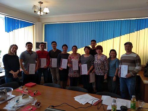 Right: Certification presentation after delivery of a GIS training course with geologists from the State Committee for Industry, Energy and Subsoil Use (SCIESU) in the Kyrgyz Republic
A key element of the programme, across all partner organisations, is training. BGS trains counterpart staff to make the best use of the new equipment, to increase their software skills and to interpret and use digital geological data and information. Knowledge gained by our counterparts during formal training is reinforced through one-to-one knowledge transfer.
We also work with partner organisations to develop data resources – for example, helping to scan and catalogue geological maps and reports. This ‘Documentation Centre’ protects the knowledge base against loss by fire or flood (or insect: termites love eating geological reports!), and makes that knowledge more easily discoverable and therefore useful. The searchable catalogue can then be published on the web, subject to approval by partner organisations. The ability for third parties to discover reports and maps which they can request to purchase provides potential revenue for the partner organisation.
Data resources are developed following ‘FAIR’ data principles (Findable, Accessible, Interoperable, and Reusable; https://www.force11.org/group/fairgroup/fairprinciples). This is achieved by making standards-based human- and machine-readable metadata catalogues, and by basing databases on published schemas and vocabularies; for example, those developed by the Commission for Management and Application of Geoscience Information (CGI; http://www.cgi-iugs.org/), and BGS’ own published vocabularies like the Rock Classification Scheme (https://www.bgs.ac.uk/bgsrcs/).
The importance of a geological map
In 1815, William Smith’s geological map of England and Wales represented the most advanced geological data of its day. Since then, the UK has been fortunate to have had the resources to develop multiple updated iterations of Smith’s map, and to store large amounts of geological data.
Transferring geological knowledge is essential, whether through traditional fieldwork, using remote sensing, lab and sampling techniques or using geoscience software. The importance of an accurate geological map cannot be underestimated. Imagine if we were still working with those original maps – it really would be impossible to get to where we are today. This is the issue faced by developing countries, and why the development of partnerships based around geological skills and data is so essential.
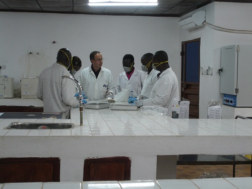
Below: BGS discussing lab procedures with National Minerals Agency staff in Sierra Leone
Authors
By geologist Darren Jones and geoscience data specialist Tim McCormick from the British Geological Survey
Acknowledgements
Thanks go to the partner country organisations mentioned above and the UK Department for International Development for supporting this project
Further reading
Goodenough, K.M.; Jones, D.; Ford, J. 2018 Geological mapping of Sierra Leone: baseline assessment and next steps. Nottingham, UK, British Geological Survey, 19pp. (OR/18/004). URL
http://nora.nerc.ac.uk/id/eprint/519869
Partnerships for Development (DFID). 2020. https://devtracker.dfid.gov.uk/projects/GB-1-205191