Dan Bosence, Peter Burgess, Arnaud Gallois, Estanislao Kozlowski, Ian Billing and Bernie Vining explore the predictability of carbonate mounds in Dorset’s Jurassic coast and the implications for petroleum exploration and production.
 Are Jurassic microbes predictable? Why would you want to know?
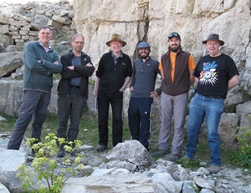
BIThe “Modelling Mesozoic Microbialites” team in quarry exposure on Isle of Portland. Left to right Dan Bosence (RHUL), Peter Burgess (formerly RHUL), Bernie Vining (formerly Baker Hughes), Estanislao Kozlowski, Arnaud Gallois (RHUL) and Ian Billing (formerly BP).
For many years there has been limited academic research into microbialites; however, their time has come! The giant oil discoveries offshore Brazil in the last decade has resulted in a renaissance of interest into how microbial communities construct microbialites, and how we might predict their genesis, distribution and character as oil reservoirs.
This has significant implications for the petroleum life-cycle from exploration through development to production. For example, in offshore Brazil in excess of 50 billion barrels have been discovered in what have been interpreted as microbialite reservoirs. There is further potential in other parts of the world: e.g., on the conjugate margin in West Africa. The drilling of each well can cost upwards of US$ 150M. Better prediction of microbialites will have major economic consequences.
Setting the scene
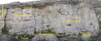
Fig. 2. Quarry faces like this one (Isle of Portland) allow facies to be mapped out in 2-D and lateral and vertical facies relations to be studied. The microbialite mounds are bounded, bottom and top, by paleosols and constructed mainly by thrombolites that nucleated on trees and branches (preserved as cylindrical holes in quarry face).
Currently, microbialite mounds, unless stacked one upon another, may not be resolvable on seismic data. In addition, there is only limited core material, given the possible geographic extent of the play. Is this core material representative? How would the perceived potential of the play be influenced by drilling through a highly productive microbialite mound, in contrast to drilling through the relatively low producibility of the inter-mound facies? If the latter were drilled first, would there be any incentive to continue exploring for mound reservoirs?
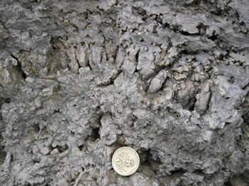
Fig. 3. Thrombolites are the major mound-building facies and preserve a large amount of primary framework porosity. Here, partially filled with geopetal sediments (centre of picture) and later fringe cements (23mm coin for scale).
In exploration, having an understanding of the environment of deposition and the distribution of facies within a time-slice is critical. Can a map be constructed to show the distribution and size-range of the microbialite mounds in a lateral sense? What are the controls on their location, concentration and growth? In addition, using a sequence stratigraphic approach, what are the vertical stacking patterns; aggradational, progradational, retrogradational?
Lateral and vertical variations in facies have a profound effect on reservoir continuity and connectivity. In field development, a better understanding of microbialite distribution and characterisation can enable the optimal location and spacing of these expensive wells and, in some cases, reduce the number of wells drilled. In production, this acquired knowledge may be applied to well planning; deviated, S-shaped and horizontal well-designs to target the highly productive mound facies. There are many unanswered questions and many challenges!
 An approach, and a possible answer to some of these questions is to ‘go back to the rocks’. Detailed field outcrop studies, integrated with state-of-the-art numerical forward modelling techniques, have provided some new insights into microbialite predictability. This was the catalyst for the recent research at Royal Holloway, University of London sponsored by Baker Hughes and BP (Fig. 1).
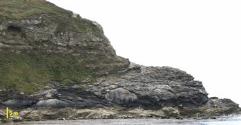
Fig.4. Rare examples of extensive bedding plane exposures provide valuable evidence for plan-view shapes of mounds; their sizes and spacing. East Point, Lulworth Cove. Here, the upper surface of the Hard Cap mounds are partially exhumed on the bedding surface dipping to the foreground. The upper cliff comprises the Broken Beds, currently widely regarded as an evaporite collapse breccia.
Field-based studies
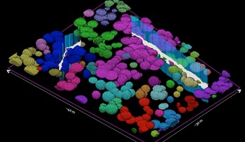
Fig. 5. Static modelling using Petrel software enables a 3-D visualisation of mound size and spacing when conditioned by two adjacent vertical 2-D quarry face exposures (shown in grey). Different colours indicate mounds that are touching, and therefore likely to have connected pore systems.
Our research has established that the lowest units of the Purbeck Limestone Group (Mupe Member) are characterised by microbial mounds that occur in three cycles, or depositional sequences, each separated by an emergent soil horizon or paleosol (Fig. 2; Gallois et al., in press). Together these are locally known by their traditional quarrying terms as ‘Caps’ and ‘Dirt Beds’ respectively. The absence of marine fossils, primary evaporites and freshwater algae indicate that these accumulated in brackish lakes on the western margin of the Wessex Basin.
The paleosols and their fossil trees, extensively studied by Jane Francis, formed forested landscapes around the Purbeck lakes and were flooded in three periods of lake expansion. Brackish-water tufas (microbialites) formed around the bases of trees, or independently from trees, and these form the nuclei to microbial mounds, up to four metres thick and 20m across.
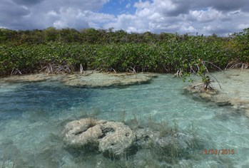
Fig. 6. The fresh-water Laguna Bacalar, in Quintana Roo region of Yucatan, Mexico - a valuable analogue for microbial mounds of the L. Purbeck Limestone Group. Here, in lake margins, mounds develop initially around shoreline trees (mangroves that form part of an ecological succession through to more mature vegetation and soils, background). Together these facies are accumulating in a regressive highstand succession from lake floor, through lake margin mounds, to emergent soils.
The tufas are complex vuggy lithologies but are principally constructed by thrombolites (microbial limestones with a clotted texture) with minor stromatolites, but also invertebrate burrow boundstones that form initially around the trees. This unusual facies is formed of peloidal muds that are bound by burrow walls to form collars around the trees. Microbial filaments trap, bind and cement the locally produced peloidal, skeletal and intraclastic grains to form a framework that is itself cemented by early calcite cements.
Framework pores are partially filled with internal sediments and early cements (Fig. 3). The resulting microbialite preserves a large amount of original primary porosity, which makes such lithologies of interest as potential reservoir rocks. Surrounding intermound areas accumulated rudstones, grainstones and packstones comprising peloids, intraclasts and skeletal fragments (ostracods and molluscs) in moderate-energy, shallow, lacustrine waters.
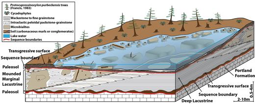
Fig. 7. Facies model for microbial mounds of the L. Purbeck Limestone Group accumulating between two emergent soil horizons. Trees assisted in mound development by providing localised relief and hard substrate for microbial mound growth.
Following lake flooding and mound growth, lake level fell and the deposited limestones were subjected to subaerial erosion to form a microkarstic surface. This represents the sequence boundary prior to the development of the next paleosol (lowstand and transgression) and the overlying microbialite bearing sequence. The close association of microbial mounds with soils indicates that they formed in shallow lacustrine settings.
Brackish waters are inferred by the absence of in situ primary evaporite minerals and also freshwater algae (Charophyta) and by the presence of brackish-water molluscs and a mixed-salinity ostracod assemblage. The sulphate evaporites of the Purbecks (well known through the work of Ian West) are now accepted to occur after the earlier brackish-water phase that contains the microbialites.
 Numerous natural cliffs and quarry sections expose 2-D vertical sections through these classic outcrops and a small number of outcrops show plan views of the mounds, illustrating elliptical to circular morphologies (Fig. 4). However 3-D outcrops are largely absent.
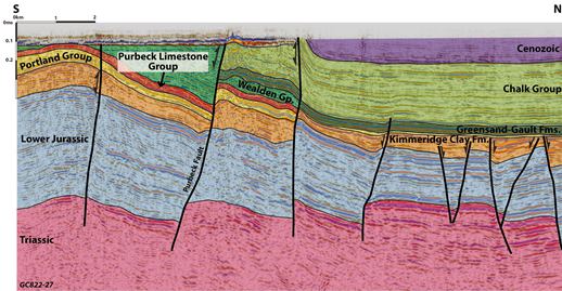
Fig. 8. North-south commercial seismic sections indicate accumulation of Purbeck strata in hangingwall depocentres to the S. of E-W oriented extensional faults (e.g. Purbeck fault). The faults are subsequently inverted (double arrow symbol) during Cenozoic compression (seismic profile courtesy UKOGL).
3D from 2D
Visualising 3-D morphologies and sizes of the mounds, and their possible connectivity, is challenging because of the 2-D nature of the outcrops. This aspect is commonly of importance in palaeoenvironmental analysis but also when assessing such structures as hydrocarbon reservoirs in the subsurface. Two approaches have been used.
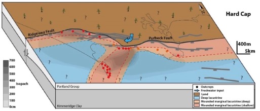
Fig. 9. Tectono-sedimentary model for the Hard Cap division of the L. Purbeck Limestone Gp., based on seismic and well data, and outcrops (circles) along Dorset coast including Portland. Isopachs (in cm) indicate thickening of the Hard Cap in areas central to faults and adjacent to central relay ramp area that accumulate the shallow, mounded marginal lacustrine facies.
Firstly, Lidar surveying of vertical quarry faces and outcrops has provided data on shapes and sizes of mound and intermound areas in 2-D vertical cross-sections and in a number of different orientations. These confirm that the mounds have irregular, interfingering relations with intermound sediments and that there are no preferred shapes or orientations of the mounds. Secondly, static modelling has been undertaken in Petrel to reconstruct mound distribution in 3-D when constrained by adjacent 2-D quarry faces of varying orientations (Fig. 5). This allows us to predict the likely arrangement of mounds, and their connectivity in 3-D.
While there are no known precise analogues for these brackish-water mounds, some western Australian coastal lakes have similar, small thrombolite buildups in a ‘Mediterranean’ climate setting (e.g. Lake Clifton). However, Laguna Bacalar in Yucatan, Mexico has more similar microbial mounds and relationships between mounds initiating around trees and subsequent soil development - albeit in a freshwater setting (Fig. 6).
The combination of outcrop-based data on facies, their vertical and lateral relationships, 3-D visualisation and the Laguna Bacalar analogue have all been used by Gallois et al. (in press) to erect a new facies model for the accumulation of the lowest part of the Purbeck limestones (Fig. 7). This provides a qualitative prediction for the establishment of microbial mounds in shallow lacustrine settings.
Sub-surface data
 To establish the basinal setting for the accumulation of the Purbeck Limestone, we need both subsurface and outcrop data. Because of the hydrocarbon prospectivity of the Wessex Basin, a large amount of seismic data exists (albeit of variable vintage and quality). These data indicate that the Purbeck Limestone Group accumulated in, and is now preserved within, hangingwall sub-basins to the south of the E-W oriented Purbeck-Wight and the Ridgeway faults that were subsequently inverted during Cenozoic compression.
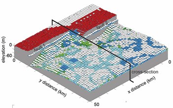
Fig. 10 (above, below). 3-D stratigraphic forward modelling of accumulation of lower Purbeck Limestone Gp for the same area of south Dorset shown in our tectono-sedimentary model in the previous figure. Modelling includes the evolving Ridgeway and Purbeck extensional faults with hangingwall subsidence and footwall uplift (emergent areas-red). Depocentres and facies (In situ microbial carbonate production (blues) and transported facies (greens) are predicted for the relay ramp and hangingwall basin. Note increased areas of in situ carbonates in relay ramp and shallow areas of the hangingwall dip slope.
Formation tops, tied to wel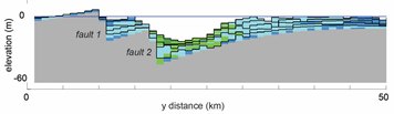 l data, identified in N-S oriented seismic sections indicate that strata thicken progressively from the footwall to hangingwall sub-basin sites, thus indicating the Late Jurassic extensional movement on the major E-W faults (Fig. 8). This evidence confirms the syntectonic setting of the Purbeck Group and the existence of E-W elongate lakes in the hangingwall areas to the extensional faults - as proposed earlier by Underhill.
The facies model has been integrated with isopachs and traces of active extensional faults so that facies can be displayed on a palaeogeography of the study area in a tectono-sedimentary model (Fig. 9). An example is given for the main microbial mound-bearing unit, the Hard Cap. This shows thicker strata near the centre of the Ridgeway fault and thicker and shallower waters with microbial mounds to the south of the relay ramp between the Ridgeway and the Purbeck faults.
 Fig. 11. (Above, below) A comparison between two reservoir models derived from data collected in the field. “Blobs” represent microbial mounds and mound complexes and colours identify connected mounds. Mound/intermound ratios and mound sizes are used to calibrate both the classical static model (left) and the stratigraphic forward model (right). In the former, the grid is populated with geobodies (microbial mounds) using a geostatistical approach. On the right the grid and microbial mounds are generated by modelling geological processes, allowing a process-based 3D modelling of the reservoir. The fences indicate locations where field data was collected.
Rel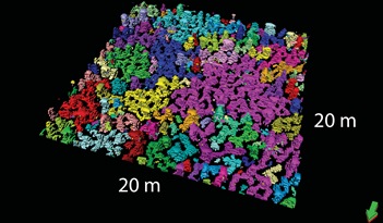 ay ramps are expected to be favourable sites for carbonate sediment accumulation, as they provide extensive areas for areas of shallow-water for carbonate production. In addition, greater concentrations of dissolved carbonates would be supplied to the lake waters through drainage channels funnelled through the ramp from the carbonate-rich footwall area undergoing erosion at this time. The location and NE – SW orientation of this shallow area is similar to that interpreted previously by Townson and by West as a ‘swell’ that influenced accumulation of the Portland and Purbeck limestones.
Forward modelling
An independent approach to the problem of predicting where facies will occur is through forward numerical modelling. Process rates taken from modern depositional settings and fault-related subsidence are used to simulate carbonate stratigraphies in successive, geologically realistic time-steps. This allows us to bridge the gap between detailed outcrop-based observations and facies models with larger, basin-scale reconstructions. The 3-D modelling of sedimentary and tectonic processes, and the ability to interrogate multiple-scenario simulations, enables us to recognise the relative importance of the major controlling parameters in tectono-sedimentary models (Fig. 10).
A modified version of Carbo-CAT (Burgess, 2013) was used to study the growth, erosion and redeposition of microbialites as controlled by supply of dissolved carbonates, depth-related microbial carbonate production with varying hydraulic energy, subsidence rates, lake level changes and a fault-related topography. The 3-D model illustrated (Fig. 10) is based on the same study area in south Dorset as our tectono-sedimentary model (Fig. 9).
Predominant elements include the two extensional faults, the erosional footwall and the hangingwall depocentre and the relay ramp. Modelled strata are compared with stratigraphic logs from the same location to compare the thicknesses and broad facies classifications (in situ-produced versus transported microbial facies) in order to determine model parameters that best replicate observations.
The object of this exercise is to not only to find a good match, but also to understand the effect that different model parameters have on the resulting facies occurrence. This enables the program to make predictions in other palaeogeographic and temporal settings. Therefore multiple model-runs following systematic variations in the initial conditions and the parameter values are performed so as to refine the prediction of the controls on facies occurrence.
As well as basin margin-scale modelling (to assist with large-scale facies predictions), forward stratigraphic modelling can be used to model the local distribution of mounds and intermound facies (Fig. 11). Comparisons of classic static modelling in Petrel are made with predictive forward numerical modelling, both informed by outcrop data from quarries with faces of varying orientation.
Conclusions
Predicting the occurrence of microbialite mounds can be achieved in this setting though detailed fieldwork when combined with mapping the syndepositional tectonic setting using subsurface data. This prediction can be extended to other basin settings, using forward stratigraphic modelling based on known environments and growth rates of microbial communities, controlling process rates for extensional basins and interpreted rates of lake-level change.
However, predicting whether or not microbialite mounds might occur in other lacustrine basins is a much harder nut to crack as lake hydrology is extremely variable and localised, being dependant on climate, fluvial architecture and hinterland geology. Despite these scientific questions, for which we still await answers, progress has been made in predicting mound distribution; with important implications for hydrocarbon exploration and production.
Outcrop analogues and forward stratigraphic modelling can help reduce uncertainty in exploration risk for the enigmatic lacustrine carbonates of the South Atlantic. Understanding likely facies belt distributions is critical in chasing an optimal exploration trend, especially when several opposing depositional models may exist.
The iterative testing of different solutions using stratigraphic modelling can improve our predictive capability; capturing the range of possible outcomes; reducing uncertainty and achieving a better understanding of risk.
Further Reading
- Bosence, D.W.J. 1987. Portland and Purbeck Formations of the Isle of Portland. In: Riding, R. (ed.) 4th Symposium on Fossil Algae, Excursions Guide, Cardiff.
- Burgess, P. M. (2013). CarboCAT: A cellular automata model of heterogeneous carbonate strata. Computers & Geosciences, 53:129 – 140.
- Francis, J.E. 1984. The seasonal environment of the Purbeck (Upper Jurassic) fossil forests. Palaeogeography, Palaeoclimatology, Palaeoecology, 48, 285-307.
- Gallois, A. 2016. Late Jurassic lacustrine carbonates; a multi-scale analysis of the Mupe Member (Purbeck Limestone Group) of the Wessex Basin, UK. Unpublished PhD thesis, Royal Holloway University of London.
- Gallois, A., Bosence, D.W.J. and Burgess, P. (in press). Brackish to hypersaline facies in lacustrine carbonates: Purbeck Limestone Group, Upper Jurassic-Lower Cretaceous, Wessex Basin, Dorset, U.K. Facies.
- Gischler, E., Gibson, M.A. a Oschmann, W. 2008. Giant Holocene Freshwater Microbialites, Laguna Bacalar, Quintana Roo, Mexico. Sedimentology, 55, 1293-1309.
- Kozlowski, E.N. 2017. Multi-scale forward modelling of microbial lacustrine carbonates. Unpublished PhD thesis, Royal Holloway University of London.
- Townson, W.G. 1975. Lithostratigraphy and deposition of the type Portlandian. Journal of the Geological Society, 131, 619-638.
- Underhill J.R. (2002) Evidence for structural controls on the deposition of the Late Jurassic-Early Cretaceous Purbeck Limestone Group, Dorset, southern England. In: Milner A.R. and Batten D.J. (eds) Life and environments in Purbeck times, Special Papers in Palaeontology, 68, Palaeontological Association, London, 21-40.
- West, I.M. 1975. Evaporites and associated sediments of the basal Purbeck Formation (Upper Jurassic) of Dorset. Proceedings of the Geologists' Association, 86, 205-225.
- West, I.M. 2013a. Purbeck Formation - Facies and Palaeoenvironments. http://www.southampton.ac.uk/~imw/purbfac.htm
Authors
Prof. Dan Bosence1, Prof. Peter Burgess1,2, Dr Arnaud Gallois1,3, Dr Estanislao Kozlowski1,4, Dr Ian Billing5, and Prof. Bernie Vining1,6.
1: Department of Earth Sciences, Royal Holloway University of London, Egham, Surrey, TW20 0EX, [email protected]. 2: Department of Earth, Ocean and Ecological Sciences, University of Liverpool, Jane Herdman Building, Liverpool L69 3GP, [email protected] 3: [email protected] 4: [email protected] 5: GeoScience Department, University of Derby, DE22 1GB, [email protected] 6: Vining Geoscience Ltd, Guildford GU1 2JN, [email protected]