Stuart Archer* explains how the UK voted to ‘remain’ 150,000,000 years ago.
Long before the U-kipper evolved, the North Sea had a lively debate about whether the UK should remain part of the European continent.
It all started in the Triassic with early musings around a split, but nothing materialised - except widespread division. In the Middle Jurassic, a thermal dome rose up to question the North Sea’s tectonic status quo, resulting in widespread upheaval stretching as far as the Inner Hebrides. This uprising was followed by an outpouring of lava that sent a very clear signal regarding the intention to ‘split’.
 However, the Rattray Volcanic Party was from the centre ground (of the North Sea’s triple junction) and the volcanism turned out to be nothing more than geological sabre-rattling. The uprising - and the heated debate about the viability of lava in the North Sea - was finally quashed as a major marine transgression poured cold water on the movement.
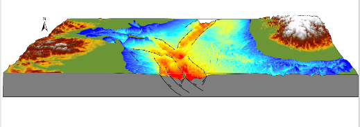
Fig 1. 3D perspective view of the North Sea’s Jurassic rift, revealing the seismically interpreted top of the Jurassic (Base Cretaceous Unconformity).
Then, 150 Million years ago, in the Late Jurassic, a geological referendum was finally held, after a seismic scale “should-I-stay-or-should-I-go-now”-themed geo-political Clash. With an almighty rift between the two camps, the political process, that geodynamicists call ‘crustal scale Hokey Cokey’, finally ended. The political outcome that the dinosaurs in Jurassic Park woke up to on Friday 24 June, in the Late Tithonian, was a narrow majority vote to stay. The North Sea lithosphere had spoken, the settled will was that the UK would remain in Europe and the rest, as they say, is geological history.
But where exactly was this geopolitical battleground? The North Sea is a world class laboratory detailing the evolution of a sedimentary basin, and seismic data have allowed geoscientists to (remotely) re-visit the site of the disruption. The signature of the failed rift, where the evidence for incipient breakup is clearest, is in the South Viking Graben - an asymmetric graben bounded by a large master fault to the west (Fig. 1).
At the time, this rupture would have experienced numerous large earthquakes, and these seismic events led to the creation of a deep half-graben on the Late Jurassic sea floor. Although other faults would have no doubt been involved in the extensional mosaic, this bounding fault of the East Shetland Platform would have taken up a large component of the cumulative Beta factor. If the rift phase had continued, the South Viking Graben Fault would have been the most likely candidate to become the master structure on the passive continental margin. This is surmised because it has the largest downthrowing, seaward dipping fault plane in the region before a polarity switch to smaller west-facing faults on the Norwegian rift margin (see Fig. 2).
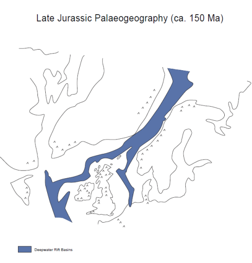
Hit the hypothetical fast-forward button, allowing extension to ensue, and Late Jurassic syn-rift faulting would have been followed by more extreme crustal thinning, dyke emplacement, the development of oceanic crust and – break-up. As time-served geological imagineers, we can conceive of the East Shetland Platform representing the North American continental margin, and the South Viking Graben Fault the newly created shelf-edge. Do remember that all this was taking place with North America still watching closely from the sidelines as the incipient Atlantic Ocean was then nothing more than a narrow seaway - more ‘Gulf of Corinth’ than ‘Gulf of Mexico’, in terms of scale (Fig 2)!
Fig 2. Decision Day. Paleogegraphic reconstruction at the end of the Jurassic, when the North Sea and the proto-Atlantic Margin were both undergoing rifting.
Along strike from the South Viking Graben, it is less clear exactly where the final tectonic failure and break up would hypothetically have taken place. Here, I postulate that the line of breakup would have extended south through the Central North Sea triple junction, where the Rattray Volcanic Province had already been erupted at a site of major crustal weakness, and down along the Central Graben (Fig. 1); although the exact position and possible extension south into mainland Europe are beyond the scope of this parochial offering.
Eventually, after millions of years of doorstep canvassing and letter-box choking initiatives, the North Sea Brexit campaign trail finally goes cold in the Early Cretaceous. Following the tumultuous decision to stay, the North Sea enters a post-rift phase, hailing a period of tectonic quiescence; but the struggle continues, and a new geo-political front now opens up West of Britain, on the Atlantic Margin (Fig. 2).
Following the ubiquitous Triassic - Jurassic rift phases, Cretaceous and Early Tertiary stretching eventually leads to more outpourings of hot air (and associated lava) which intensifies towards yet another ‘polling day’. As voter-fatigue sets in, continental break-up is ultimately precipitated by the creation of a new political party, called Oceanic Crust, in the Early Eocene at around 50Ma. It is the arrival and subsequent growth of this new entity that eventually leads to the departure of the North American continent from the European scene.
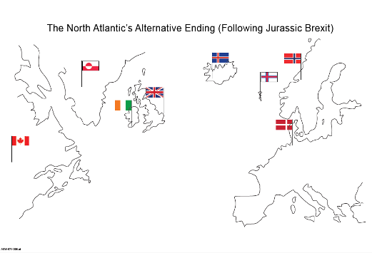
But “take a look at what you could have won”, if the North Sea had actually progressed to become the Atlantic Ocean (Fig. 3). From my desk here in Copenhagen, it is clear that the Danish would now get all the dreich weather off the Atlantic that the west coast of Scotland currently enjoys. Would the Danes now have the same political relationship with the UK as they currently have with Greenland, or would Nova Scotia now be bolted tae Auld Scotia (which has to have had fewer midges than the real Scotland)? Moreover, Donald Trump’s mother might have been born in Halifax rather than Stornoway……and the Presient’s ‘crazy golf’ ideas may never have blighted Scotland!
Moving on swiftly…..
 If you feel that I have left you short-changed, with the scientific cliffhanger unanswered (namely, why the geological tug-o-war in the North Sea ended and why the concept of the Mid Atlantic Proto-Parliament moved the location of its debating chamber via long boat from the Viking Graben to Thingvellir on Iceland) – consider this. Put simply, the European crustal bond was just too strong.
Fig 3. Imagineer’s impression of how the North Atlantic might have looked geopolitically if the UK had voted for Jurassic Brexit.
So what does the future hold in terms of neotectonic machinations? Well, they say that history (and sometimes geology) repeats itself. In this case, rather than staying co-joined as we did in the Jurassic, new seismic activity has recently been detected by the BGS – not between the Rock of Gibraltar and mainland Spain, but along the western margin of the Viking Graben - for the first time in (as far as we know) 150Ma! It’s true folks, we can at last now say, using scientific evidence, that the Brexit vote has had seismic ramifications.
Finally, let us quickly examine some other well-known geo-political linkages that exist in the UK. Politicians often try to look back into geological time to support ideologies; such as Scottish Independence – easily justified by the Iapetus Suture. The Highland Boundary Fault provides an elegant geological explanation for the topographic and therefore cultural divide that exists between Teuchters and Sassenachs (see footnote). After much research on my part, The Purbeck Disturbance, although it sounds serious, actually turned out to be a small scale breach-of-the-peace offence after one or two libations were taken following a hot day in the field on the Jurassic Coast. And last, but not least, as we are all aware, the good people of Cornwall have been strongly affected by The Variscan Front.
Maybe it is time for us to turn the tables and use the newly heightened interest in politics to help the man on the street grasp geological concepts. We could be on the verge of a new era of geoscience communication and public outreach. Or not.
 Stuart Gordon Archer (pictured piping in the Lower Library, Burlington House), Copenhagen, 2 April 2017
Acknowledgments
Thanks to friends, family, colleagues and former colleagues for their help with the text and for drafting the figures.
Footnote:
- Teuchters - those Scots who live north of the Highland Boundary Fault.
- Sassenachs - those who have never even heard of the Highland Boundary Fault!