Product has been added to the basket

Metal mining - who pays for the clean-up?

Discharge point on Saltburn beach (under bridge), with Cleveland Ironstone Formation exposed in cliffs.

Richard Lord* and Don Mason# report on iron-rich minewater issuing from an abandoned Cleveland Ironstone mine, and find a hole in the legislation


Geoscientist 20.06 July 2011


Saltburn Gill is a narrow wooded stream valley, leading directly off Saltburn's famous surfing beach, near to the historic pier, hydraulic cliff railway and other tourist attractions of this popular Victorian resort town. Much of the Gill is a nature reserve, designated a Site of Special Scientific Interest as a relict of postglacial native woodland. It is a popular walking area, and wildlife attractions include kingfishers and visiting otters. But there was trouble brewing under this paradise.

Ochreous minewater appeared overnight in the Saltburn Gill Beck on 18 May 1999, and quickly turned this otherwise high-quality watercourse bright orange, devastating the downstream ecology. At around 1200 milligrams per litre of dissolved Fe, this was reputedly the second highest concentration of any UK minewater. At the emergence point (directly above the shallowest workings) a spectacular terrace of ochre sludge formed, destabilising the stiff clays filling this pre-glacial valley.


Map of worked area of Cleveland Ironstone and localities referred to in text.
The mine water emergence point in Saltburn Gill. The discharge is related to former ironstone workings in the area, but as the mines were abandoned well before 1 January 2000 no legal responsibility rests on current landowners or former operators to treat the problem, even if operators could be identified. Metal mines were excluded from the Coal Authority’s duty to remediate similar water pollution emanating from coal mines - a position established under their Memorandum of Understanding with the Environment Agency in 1999.

Surprisingly, minewater contributions to river and sediment contamination are also excluded from the Mine Waste Directive, which does nonetheless include measures to identify any significant risks from solid wastes at the 86,869 known UK mine and quarry sites. Yet together, such diffuse pollution sources from mining activity and point-source discharges from “orphan” mines threaten to prevent the UK meeting the 2015 first-cycle deadline of good and improving status set by the European Union Water Framework Directive. In England and Wales, the Environment Agency estimates that 6% of surface water bodies are at risk from pollution arising from abandoned non-coal mines. This includes 1650 workings for iron, and at least 1969 for other metals or gangue minerals.


Impact of minewater on Saltburn Gill Beck approaching Saltburn beach.

ACTION GROUP


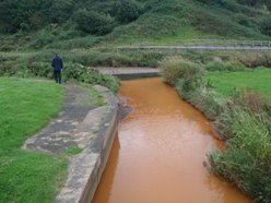
Following a series of academic investigations the Saltburn Gill Action Group (SGAG) was formed in 2005. It is a community-based organisation, comprising local residents and representatives of local Parish and District councils, Tees Valley Wildlife Trust, local Environment Agency officers, Groundwork and geoscientists from Teesside University. Its aim is to address minewater pollution and its consequences within Saltburn, with the ambition to return Saltburn Gill and Saltburn Gill Beck to their pre-1999 condition.

By 2006 the Group had raised enough money to commission environmental consultants Entec UK Ltd to conduct an initial scoping study in 2007, followed by feasibility studies. These included investigating the condition of a nearby open shaft (2008), seasonal groundwater and hydrogeochemical monitoring (2009), and a regional review of interconnected mineworkings (2010). With funding from the Environment Agency, DEFRA and assistance from the Coal Authority, two monitoring boreholes and a larger abstraction well were drilled (2009-10), leading to the outline design and costing of likely “pump and treat” options.

HISTORICAL WORKING


Although worked for centuries, industrial underground mining of Lower Jurassic sedimentary Cleveland Ironstone Formation began around Teesside in the 1850s, following the discovery (by John Vaughan and John Marley) of the Main Seam outcrop in the Cleveland escarpment, so establishing today’s tradition of iron and steel making. Iron ore production peaked at 6.5Mt in 1883, dominating UK production until 1912 (with a total of 371Mt extracted). The last surviving mine, North Skelton, ceased production as recently as 1964.

Four principal seams were worked in this area: Avicula, Two Foot, Pecten and Main Seam. This last was the most important, stratigraphically highest, and, at typically 2.5-3m, thickest. The gently dipping seams were worked by stall and pillar methods on a rectilinear plan. Typically, two 3.6m-wide parallel roadways were driven, 9m apart, to the full height of the seam. Perpendicular tunnels or “boards” were driven for ventilation at 9m intervals. Passages were also driven at right angles to the roadways at 4.5 to 9m intervals, also with perpendicular “boards”, until the limit of working was reached. Away from villages, pillars were subsequently reduced to 1.5m2 columns as temporary support, then either allowed to collapse or removed by “goafing” (extracted and replaced with props) as mining retreated back towards the shaft.

Partial extraction rates varied from 30-60% where pillars remained, to 85-90 % for total extraction. Although in theory unmined barriers were left between different mines, abandonment records show that these were also often partially removed or cut by later drainage or ventilation drives connecting the shafts of the original mines. The result today is an interconnected area of higher permeability collapsed workings extending over the entire orefield.


Conceptual model for minewater breakout in Saltburn Gill.
Cleveland Ironstone mining (reproduced by permission of Teesside Archives and the British Steel Archive Project)

ORIGIN OF IRONSTONE


The ironstone seams were formed in shallow marine conditions and comprise ooliths of the iron silicates chamosite and berthierine, set in a matrix of siderite. Crucially, the upper part of the Main Seam was highly pyritic and was even mined separately and sold for sulphuric acid production (perhaps providing a clue to the probable origin of the minewater issue). In any mine with this gangue mineral, oxidation of pyrite upon exposure to air or oxygenated water – often catalysed by microbes – is what creates acid mine drainage. Pyrite is especially reactive if fine-grained and framboidal, as it commonly is in many sedimentary rocks or coal seams. Yet in most cases, Cleveland minewater discharges are only weakly acidic where they emerge.

Professor Paul Younger (University of Newcastle) suggests that any acid formed is neutralised by the dissolution of iron carbonate, a process that also further increases dissolved iron concentration. As evidence of this process, many discharges, including one at Saltburn, are slightly frizzante, and effervesce with dissolved CO2. However, so high is the iron concentration that the formation on oxygenation of oxy-hydroxide “ochre” precipitates can then lead to significant acidification in surface watercourses.

FIRST INVESTIGATIONS


Initial studies of the Saltburn Gill minewater problem focused on causes and impacts. Don Mason confirmed the presence of shallow workings immediately below the emergence point, as recorded on mine abandonment plans from the North Skelton Mine. These were at their northern limit and sub-crop of the main seam ironstone, which formed a shallow basin surrounding the North Skelton shaft. At this point the mineworkings rise gently northwards, whereas the land surface and incised valley of Saltburn Gill respectively slope and cut downwards in that direction, making this an entirely logical minewater emergence point. Only the staple shaft and horse drift in the valley of the Kilton Beck at Skinningrove (four kilopmetres to the east) presents a lower elevation emergence point.

More puzzling however was why minewater should appear 35 years after the mine closed and pumping ceased. Mine flooding and outflow of a “first flush” of contaminated water usually takes only a few years (as was the case in the Loftus and Carlin How mines around Skinningrove). Records of the sinking of the North Skelton shaft in 1870 show that cast iron “tubbing” (shaft casing) was required to penetrate saturated sand lenses in till, and the sandstones of the unconformably overlying Middle Jurassic Saltwick Formation - a local aquifer. With abandonment and collapse, this aquifer would eventually provide a hydraulic head to drive minewater through the flooded workings when the tubbing failed.


The outbreak also closely followed the completion of the Skelton-Brotton bypass, which runs only 500m south of the emergence point. Here, two minor historically active minewater sources were known to have emerged from an exploration borehole and a failed ventilation shaft, both just outwith the outcrop of the Main Seam workings. The new seep had appeared in wheel ruts from recent forestry activity in a location where landowners recalled seeing collapses into open workings.

The minewater flows into a tributary, some 60m above its confluence with the Saltburn Gill beck, which from this point is discoloured over its two-kilometre course towards Skelton Beck and the sea. Fortunately, although heavy metals were known to be abundant in black shales within the Jet Rock Member (Whitby Mudstone Formation, immediately above the Main Sean), Rob Helyard’s stream-sediment survey of the affected length showed only trace amounts of Cr, Cu, Ni or Zn in the Mn-bearing, Fe-rich ochre precipitates.

Mine abandonment records of the Cleveland Archives illustrated the probable interconnection between workings of different mines. A physical connection between the North Skelton and Carlin How mines could be shown, suggesting that minewaters could actually have flowed to Skinningrove under hydraulic pressure before the collapse of the intervening workings, or penetration to the surface from crown-hole collapse in Saltburn Gill. Furthermore, the workings beneath the seepage point were originally part of the Longacres Mine (800m to the south), which later coalesced with the deeper North Skelton Mine over a kilometre further south. Teesside University researchers were surprised to discover that one of the two shafts at Longacres had been left open - presumably for ventilation - when worked from North Skelton, where both had been backfilled at closure.


Pumping test results.
The Coal Authority’s passive treatment scheme, Hockery Brook, Wigan

GETTING ORGANISED


Although a forerunner Saltburn Action Group was formed in the immediate aftermath of the pollution incident and a public meeting held, this had failed to achieve popular support or local cross-party political agreement. The SGAG’s first task was to raise the money for the scoping study and to identify and cost possible treatment options. Its two-stage approach was taken from the Environment Agency’s recent work on metal mines in Wales, and was in turn based on the series of successful investigations of coal minewater issues completed by the Coal Authority. This phased approach proved advantageous to the group, as it favoured incremental fundraising. With £4500 from Skelton Marske and New Marske Parish Council and the Environment Agency, the scoping study was put out to tender in 2006. In 2007 a further £10,000 from the Agency and £16,000 from the Impetus Environmental Trust allowed SGAG to commission Entec to perform a shaft condition survey and begin seasonal groundwater and minewater monitoring. In 2009 a further £35,000 from the Environment Agency itself and £300,000 (originally from DEFRA) meant that drilling, pump-and-treat tests could be completed, together with the regional hydrogeological study.

The CCTV survey of the open Longacres mineshaft approximately one kilometre from the minewater discharges assessed it as a potential location for dewatering and treatment. The survey confirmed that fresh groundwater was entering the mine workings through the shaft walls and (worryingly) indicated that a head of 8-10m was driving the nearby discharges. Disappointingly, it also revealed that the shaft was blocked with debris only a few metres below the water table, so could not be used for pumping.

Although the Environment Agency had monitored the stream and discharge compositions after breakout, the scoping study identified the need for more comprehensive data on minewater flow and contamination (including seasonal variation) so as to allow treatment needs to be assessed. The Coal Authority installed v-notch box weirs in the receiving tributary, while nearby shafts were fitted with data-loggers. This allowed Dirk Liss of Entec to compare minewater levels and physio-chemical parameters with flow and precipitation. Water samples were collected regularly for comparative full analyses.

Results over one year showed that discharge rates remained relatively constant, with little no or response to seasonal recharge or rainfall events. The minewater temperature was also quite steady (2-3°C warmer than the expected shallow groundwater temperature, which was consistent with deep-source minewater). The total discharge volume into Saltburn Gill was only 1.5-2 litres per second, but due to the extremely high dissolved iron concentration (1100-1200 milligrams per kilogram) this relatively low flow still meant that the Saltburn Gill beck was exposed to an iron load of about 180kg per day.

The Entec study of the main mining region revealed regional hydraulic interconnection between the different mines. The Longacres-North Skelton group extends over an area of 36km2 south of Saltburn Gill and eastwards to Skinningrove. The Loftus-Whitecliff group extends over 13km2 of workings to the east of Skinningrove.

With the necessary funding in place, a limited drilling programme intersected flooded open mine workings between shaft and seep to confirm water levels and conduct a pumping test. The final arrangement (of one pumping shaft and two monitoring wells) provided the infrastructure and confirmed the regional hydraulic connection and that the minewater was coming from regionally interconnected workings. As a result, we determined that before flow would stop, a substantial volume of water would need to be removed in order to reduce the piezometric ‘driving’ head behind the polluting discharges. A two-phased approach was proposed. First, an initial de-watering phase and high volume abstraction for up to two and a half years, followed by operational pumping, at lower volumes, indefinitely.


The Coal Authority’s active treatment scheme at Horden, Co Durham.

TREATMENT


The methods proposed are similar to successful schemes operated elsewhere, at former coal mines by the Coal Authority. The options range from “passive” methods (reed beds, settlement ponds), to a fully active chemical dosing plant. Whole-life costs for these treatment options at Saltburn range from £3.3m to £7.4m, respectively. A cost-benefit analysis by RPA Consultants found that the minewater’s impact on the local economy over a 25 year ‘life-cycle’ period amounted to £10.4m. On this basis, even at the expensive end, such a treatment scheme would represent value for money and meet the Water Framework Directive targets by 2015.

All well and good. But - who is going to pay for this in the current economic climate? Even if one-off capital funding were found for a treatment scheme, the recurrent costs of operating it will also be required indefinitely. The Coal Authority was established under the Coal Industry Act to clean up discharges from coal mines abandoned before 1994, working to a ‘priority discharge list’ under the 1999 Memorandum of Understanding with the Environment Agency. To date, the Authority has completed more than 55 operational minewater treatment schemes.

The absence of a similar organisation responsible for ‘non-coal mine’ discharge has prompted DECC to include clauses in last December’s Energy Bill to allow the Coal Authority to use its experience to assist others - a move also intended to reduce the burden on the public purse. With a technical solution for Saltburn now identified, albeit at a price, local residents and SGAG members hope that DEFRA and DECC can now agree and allocate the necessary funding to allow this community-led example to spearhead a new era of UK minewater remediation within the coalition Government’s “Big Society”.


Author affiliations

  • Lord: Reader in Environmental Geochemistry & Sustainability, Teesside University, Middlesbrough
  • Mason: Environment Agency

Further reading

  • Atkinson, J Lord, R A and Lane, A (2005): Saltburn Gill mine water study – Geology & origin of mine water impacts on the Beck. Unpublished report for Tees Valley Wildlife Trust.
  • Helyard, R (2000): Investigation of acid mine drainage at Saltburn Gill, Cleveland. Unpublished BSc thesis, University of Sunderland.
  • Liss, D, Thorley, R and Gandy, C (2010): Cleveland Ironstone hydrogeology study. Conceptual model and options appraisal report. Unpublished report by Entec UK Ltd for the Coal Authority. www.environment-agency.gov.
  • Mason, D B (2000): The Saltburn “Red River” incident – An investigation into the causes, effects and remediation of mine water pollution within Saltburn Gill, Cleveland. Unpublished MSc Thesis, University of Durham.
  • Don Mason (2010): Saltburn Gill. The River Legislation Forgot. www.youtube.com
  • Mayes, W M, Johnson, D, Potter, H A B & Jarvis, A P (2009): A national strategy for identification, prioritisation and management of pollution from abandoned non-coal mine sites in England and Wales. I. Methodology development and initial results. Science of the Total Environment 407, 5435-5447.
  • Paulumboe-Roe, B and Colman, T with contributions from Cameron, D G, Linley, K and Gunn, A G (2010): The nature of waste associated with closed mines in England and Wales. British Geological Survey Open Report, OR/10/14. 98pp.
  • Younger, P (2002): The importance of pyritic roof strata in aquatic pollutant release from abandoned mines in a major, oolitic, berthierine-chamosite-siderite iron ore field, Cleveland , UK. In Mine Water Hydrogeology and Geochemistry (P. Younger & N.S. Robins, eds.) Geological Society Special Publication 198, 251-266.