Kit Hardman unravels void formation and collapse during seismogenic slip in the Canisp shear zone, North West Scotland
Hardman, K., Cracking Canisp: Deep void evolution during ancient earthquakes.
Geoscientist 29 (1), 10-15, 2019
https://doi.org/10.1144/geosci2019-003; Download the pdf here

Above, View of Achmelvich bay on a rare sunny day, looking south.
The Lewisian Complex—a suite of Precambrian metamorphic rocks outcropping in the NW highlands and has long-held the interest of many in the geological community. So much so that you could be forgiven for thinking there is little more to learn from this region of the North West Highlands. But the truth is, as our understanding of sub-surface processes develops and our analytical tools and methods improve, we continue to uncover a wealth of knowledge hidden in those well-weathered outcrops.
The processes that occur during earthquake slip at different depths are still poorly known. So, in the hope of gaining new insights, I am investigating a variety of different rock outcrops to assess how fracture-hosted cavities, or fault voids, develop and evolve during deformation at a range of depths throughout the upper crust. The Canisp shear zone (CSZ), which is part of the Lewisian Complex, represents rocks that were deformed at depths above and below the brittle-ductile transition zone. So, I ventured to the Scottish Highlands to investigate the CSZ, which is exposed in Achmelvich Bay and Clachtoll. These rocks represent the oldest and deepest of all my study areas.
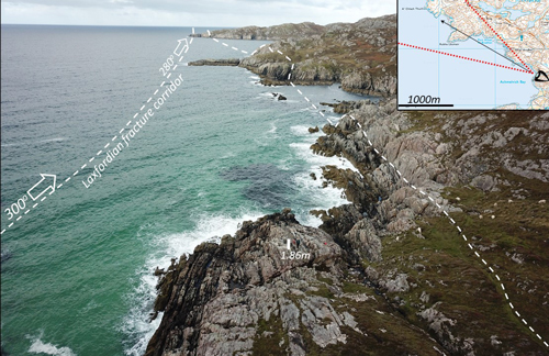 Right, Annotated aerial photo of the North side of Achmelvich Bay. Taken with a DJI Mavic pro UAV. Annotations show the trace of the largest of the mapped fracture corridors in the Laxfordian brittle shear zone.
Specifically, I wanted to assess how fault voids develop, fill and collapse in crystalline basement that deformed at depth. Rocks in the CSZ have undergone a long and often intense deformation history that includes a phase of coeval seismogenic-fluid circulation, frictional melting, hydrothermal mineralisation and complex brecciation. Using detailed mapping, microstructural characterisation, kinematic analyses and fracture-attribute analyses, I wanted to develop a better understanding of the processes controlling fault-void evolution.
I worked together with Bob Holdsworth, Eddie Dempsey, Ken McCaffrey and Tom Utley to use the latest photogrammetry techniques to develop terrain and perspective-corrected fracture and outcrop maps from aerial imagery. We collected these data using a newly-acquired unmanned aerial vehicle (UAV) quad-copter. Despite the predictable problems flying a brand-new drone for the first time on the Sutherland coast in September, the resulting imagery and models are exceptional. The photogrammetric techniques enable us to develop ultra-high-resolution maps and 3D virtual outcrop models, which, when combined with detailed field observations and field maps, allow easy collection of fracture attribute and topological data, and give an excellent view of the contemporaneous interlinked systems of faults, fractures and fills of the CSZ.
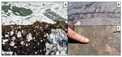
Left, Faul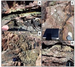 t breccias and cataclasites. A collection of epidote and quartz mineralised fault breccias and cataclasites from foliation perpendicular faults, formed during the late-Laxfordian tectonic episode.
GEOLOGICAL HISTORY
Wikipedia summarises the Lewisian Complex as “…a suite of Precambrian metamorphic rocks that outcrop in the northwestern part of Scotland, forming part of the Hebridean Terrane and the North Atlantic Craton. These rocks are of Archaean and Paleoproterozoic age, ranging from 3.0–1.7 Ga and form the basement on which the Torridonian and Moine Supergroup sediments were deposited”. Whilst undoubtedly an over-simplification, this is an excellent starting point to summarise 3 billion years of Earth History in a few hundred words.
 Right, Plan view of the Lewisian Gneiss. Well-developed schlieren textures were formed during the Badcallian orogeny. Lens cap for scale.
The Precambrian geology of the Lewisian Complex in the North West Highlands has been debated in one form or another for over 100 years. There is no consensus on the absolute timings of the various deformational and metamorphic episodes recorded in these ancient rocks (Butler, Geol. Soc. London SP 2010), but here I present my interpretation of the geological and structural history of Achmelvich, based on my field observations and the published literature.
Left, Annotated map of Achmelvich Bay. Map shows the collected structural data, field photographs and mapped boundaries.
The earliest discernible geological events in the CSZ of the Lewisian Complex are shallowly-dipping foliations, small intrafolial folds and streaky textures, or schlieren, around ultramafic pods or boudins. These are best seen on the northern limb of the Lochinver monocline (see “Annotated map of Achmelvich Bay” in the beautiful water-washed exposures either side of Achmelvich beach. These granulite metamorphic textures are products of the Badcallian orogeny, formed about 2.5 billion years ago (Park, Scottish J. Geol. 1970), at great depths under extremely high temperatures and pressures.
The next major event was the Inverian orogeny, which is post-dated by the emplacement of the many NW-SE trending Scourie metadolerite dykes 2.4 billion years ago. Thus, the orogeny occurred somewhere in the 100-million-year window between 2.5 and 2.4 billion years ago (Park, Scottish J. Geol. 1970). The Inverian here is expressed by the development of a strong sub-vertical foliation and steeply-plunging mineral lineation forming the 1.5 to 2-km-wide ductile CSZ immediately north of the Lochinver monocline. Characteristic features of the Inverian fabric are the development of tight minor folds and a regional NW-SE trending foliation. The Inverian orogeny is also responsible for the Lochinver monocline and regional amphibolite facies metamorphism (Attfield, Geol. Soc. London SP 1987). This is a lower-temperature and pressure metamorphism compared to the Badcallian event, suggesting a progressive regional uplift toward the brittle-ductile transition at about 15 km depth.
Scourie dykes are spectacularly exposed in the southern and northern headlands of Achmelvich Bay. These dykes cross-cut the Badcallian gneissic foliation fabric, but are reactivated along the margins in brittle-ductile centimetre-scale shear zones related to the next orogenic phase, the Laxfordian.
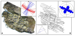 Right, Major fractures. A, Orthorectified aerial image of CSZ outcrop [58°10'33.3"N 5°18'17.1"W], with major fractures traced and manual structural measurements. B, Structural measurements isolated, with an equal area rose plot of fracture angles, and ITX fracture connectivity plot (calculated using Dave Healey’s FracPaQ module for MATLAB).
The 1.4 to 1.7-billion-year-old Laxfordian event has at least two distinct phases of deformation that track events across the brittle-ductile transition and into the earthquake realm. An earlier greenschist-amphibolite facies ductile fabric forms the centre of the CSZ, where it intensifies the pre-existing Inverian fabric in a zone 0.5 km wide. This is associated with a shallowly plunging mineral lineation, swarms of tight to isoclinal sheath folds and associated dextral shear criteria. A ‘late-Laxfordian’ event involving widespread brittle reactivation of the shear zone foliation sees a reversal to sinistral shearing. In the CSZ, a series of interlinked high-intensity fracture corridors were formed. 2 main fracture sets are recognized: sinistral foliation-parallel faults and dextral-extensional foliation-perpendicular faults. These coeval fractures are locally associated with significant volumes of frictional melt—pseudotachylite—which is injected into neighbouring dilational voids that follow the foliation-perpendicular fault set, often intermixed with well-developed fault breccias in zones up to 1 m wide and several metres long. The fractures are easily picked-out as they are stained a deep red colour by the percolation of iron-rich fluids. This Laxfordian transition from ductile-to-brittle deformation shows a continued shallowing/uplift history as the rocks cross the brittle-ductile transition at around 15 km.
The final phase of deformation comprises a series of tensile/dilational faults and fractures that opened close to the surface and were invaded by Stoer Group unlithified sediment. The best locality to observe this is in a small bay between A’Chlach Thuill and Rubha Leumair headlands. These fractures record the final arrival of the presently exposed Lewisian complex at the surface about 1.2 billion years ago, the age of the Stoer Group, where the gneiss has lain ever since (except for a few shallow burials and exhumation events during the last billion years).
FIELD DAYS
Like many undergraduate experiences of the NW Highlands, my field excursion was met with biblical winds and sideways rain, which started and ended on my first and last days in the field. Intermittent breaks in wind and rain allowed for brief flights of the UAV to collect photos for the detailed digital maps, but most work continued regardless of weather, alternating between notebooks to allow time for the other to fully dry. During the heaviest downpour, fieldwork was “briefly” suspended to seek shelter and prevent the loss of collected work. This method of stop-start fieldwork was almost successful, apart from the third day, when I watched the central half of my meticulously drawn, detailed field map rip from my mapping board and gracefully fly away across the North Minch, evidently heading back to the home of the Lewisian Gneiss on the Isle of Lewis. The fieldwork was mostly solitary except for a sea-otter, which followed me at a distance between coastal outcrops, and would observe with apparent interest my attempts at recording structural measurements at some of the less-accessible outcrops.
Given some of the meteorological-challenges, a return trip to the NW Highlands took place in the spring of 2018, where I verified and tidied-up some of the field observations and collected further data. I was also able to tie in some “Late-Laxfordian” field observations made in Achmelvich, with outcrops in Clachnessie and along the Loch Assynt fault. These outcrops featured very similar epidote/quartz breccias, kinematics, and deformational styles. I’m still investigating the hypothesised “Late-Laxfordian” event and, over the next few years, these observations will be compared and contrasted to observations and data collected from equivalent studies of fracture networks with fault-void fills formed across a broad range of palaeodepths; ranging from the near surface (Brixham SW England, Rona Ridge West of Shetland UKCS, Calabria, Italy), to other deep crustal settings (Adamello massif in Italy) as part of my larger PhD research goals.
VOIDS, FILLS AND FLUIDS
My core aim is to assess the influence of reactivation of the ductile CSZ fabrics on faulting and fault void development. I want to test a hypothesis that the fault voids and fills formed due to the rapid opening and partial collapse of large dilatant voids during ancient earthquakes. What mechanisms could open and fill fault voids at large depths and great pressure, and what are the impacts for short- and long-term fluid flow through the crystalline basement-rock?
The sinistral foliation-parallel and dextral-extensional foliation-perpendicular faults are thought to have formed simultaneously during repeated, and likely seismogenic, shear events under a regional ENE-WSW compressive stress. Despite being coeval, detailed observations show that the fault-sets are remarkably different. The foliation-parallel faults show significant offsets of several metres, with locally large volumes of generated frictional melt and the development of small drag folds in the wall rocks. The foliation-perpendicular faults show less slip, but have a much larger damage zone and complex shapes. Conceivably this makes sense: if I were to shear a block of wood it would be far easier to fault it “with the grain” as opposed to “against the grain”, and the resultant damage to the wood would be different in either case. In addition, the smaller foliation-perpendicular faults commonly connect the foliation-parallel faults like the rungs on a wonky ladder. As they grow, the ladder fill collapses into a dilatant cavity to form a heavily iron-stained, clast-supported breccia. The chaotic assemblage of wall-rock clasts shows no uniform rotation direction and no evidence of attrition. This implies that the cavities opened enough to allow wall rock collapse, with free rotation and displacement of the clasts, before the cavity partially collapsed, trapping the breccia clasts in place and propping open the fault cavity.
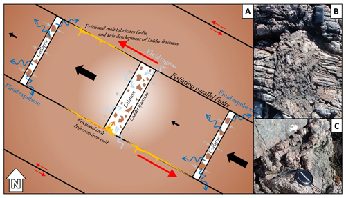 Left, Conceptual sketch of the “train-carriage” model. Demonstrates opening and partial collapse of fault voids in N-S tensile fractures. Voids rapidly open and dilate, leading to fluid, melt and fault rock infill followed by collapse and partial void closure. Wall rock clasts and fills act as props leading to the development of potentially long-lived fluid migration pathways. Also shown are field photographs of tensile fractures filled with erratically rotated breccia clasts (phone and lens cap for scale).
We initially thought that such a sequence of events might be caused by high fluid pressure widening the fracture aperture, before fluid pressure dropped and the cavity closed. But we have since discarded this idea. Instead, our work shows that the opening and closing of fracture cavities was controlled by seismogenic movement along the larger foliation-parallel faults that host friction melts with complex flow-lineation patterns. It appears that as movement along the foliation-parallel faults occurred, blocks of the adjacent wall rocks moved in the same direction, but at different times/speeds, causing them to move apart from and collide with one another, rapidly opening and closing the foliation-normal fracture cavities forming blocks. This model is conceptually similar to shunting the carriages of a train, with each of the carriages represented by adjacent fault blocks, bound by the different types of fractures. Thus, if one carriage were shunted, it would move away from one adjacent carriage, and collide with the next down the line, closing and opening the gaps between them. During opening, the cavity would be under a negative hydrostatic pressure and would draw in any fluid, bits of wall rock or frictional melt. When a cavity collapsed, larger clasts would be held in place, propping open the cavity, but anything mobile, such as fluid or any suspensions, would be driven out, circulating fluid (and perhaps melt) throughout the adjacent fracture network. The movement of these blocks is driven, we suggest, by seismic activity, and what we observe is a greater proportion of frictional melt along the foliation-parallel faults that surround these tensile fractures, compared to those that are not associated with foliation-normal ladder fractures. One possible reason for this is that during a seismic event, frictional melt is generated along the weak foliation-parallel faults, which lubricates the faults and facilitates the block shunting process.
The idea of seismically-driven fluids is not new. But, whilst we see many examples of fluids being expelled at the surface during earthquakes, the idea of seismic “pumping” at depth remains contentious (Sibson et al., J. Geol. Soc. London 1975; Muir-Wood & King, J. Geophys. Res. 1993; Matthäi, J. Geochemical Explor. 2003). The observations I made at the CSZ cannot settle the debate, but they can tell us that at this specific location we have coseismic percolation of iron-rich fluids through a deep-seated fault network in a crystalline basement rock, driven by the energetic formation and collapse of fracture cavities at significant depth (about 10 km or more). The fracture cavities here act as fluid pathways not just in the short term, but in the long term, providing a conduit for fluid to circulate through the deep basement over long geological timescales. This is counterintuitive because it is often thought that any faults or fractures in the deep crust will immediately close-up, offering only transient short-lived fluid flux. Yet, in Achmelvich, although the seismic activity is transient, we see evidence that fracture cavities never completely close-up, instead being held open by the infilling breccia material. This allows for the distribution of fluids across a large volume of rock deep in Earth’s crust.
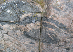
 Right, Psuedotachylite. In thin section, cross section (complete with “wing-crack injections”), and plane view (showing flow lineation patterns of injected melt); fingers for scale.
The mineralogy we observe in thin section is surprisingly diverse, with complex secondary mineral interactions. These secondary minerals include: prehnite, chlorite, epidote, clinozoisite, pyrite, quartz and chalcedony. In addition to veins, these secondary minerals frequently form both matrix and clast material in fault breccias, cataclasites and gouge (often with injection textures). The sections also show locally significant volumes of pseudotachylite, with lateral injections. Many are bubbly—consistent with rapid changes in pressure, perhaps associated with the seismic cycle and the proposed ‘block shunting’ process. The lack of universal cross-cutting relationships between the different secondary minerals and/or the psuedotachylite demonstrates the iterant, cyclical and broadly synchronous nature of these mineralisation episodes. Evidently during the Late-Laxfordian deformation there is a whole host of different fluid chemistries, local stress conditions and brecciated material migrating through these faults and fractures.
Statistical work was carried out in two fronts: analysis of the structural slip-data to generate a palaeostress field for the Late-Laxfordian-aged deformation, and topological and fracture attribute analysis of the ortho-rectified drone images of key outcrops. The palaeostress inversion was conducted using WinTensor (by D. Delvaux) and yielded a strike-slip compressive stress regime, with a major ENE-WSW compression and minor SSE-NNW extension. The ratio of principle stress differences was consistent across all Late-Laxfordian structures at around 0.30. The fracture topology and attribute analyses show that these faults networks are well-connected and orientated, with distinct fault sets separated by length.
THE UPSHOT
From this work, we can draw some significant conclusions that have real-world applications. We describe a mechanism by which cm-scale cavities have been generated and held open in an otherwise impermeable crystalline rock at extreme depths in the upper crust. Elsewhere similar cavities may be filled with economic minerals or hydrocarbons that lie unconsidered as an exploration opportunity due to their high formation depths. Going forward, a better understanding of the internal-architecture of fault and fracture cavities throughout the upper-crust can guide us to better utilise these resources.
ACKNOWLEDGEMENTS
My sincerest thanks to The Geological Society for deeming my self-funded PhD project worthwhile of financial assistance, the money and validation are of equal significance. The thanks also go to my supervisors, Bob Holdsworth: whose scientific contributions are too great to even begin listing, but most importantly taught me that sanity is overrated; Eddie Dempsey: whose careful eye and choice words made this project so fascinating and fun; and Ken McCaffrey: whose patient edits and discussion of analytical techniques were invaluable. In addition to my supervisory team the contribution of Tom Utley cannot be overlooked, since he was instrumental in helping me keep the drone airborne, and my models grounded. Thank you.
AFFILIATION
Kit Hardman is a PhD student at Durham University; e-mail:
[email protected];
https://www.dur.ac.uk/earth.sciences/research/res_groups/structural/;
https://www.dur.ac.uk/research/directory/staff/?mode=staff&id=15347
FURTHER READING
Park, R.G. (1970) Observations on Lewisian Chronology.
Scottish J. Geol.
6, 379-399.
Butler, R.W.H. (2010) The Geological Structure of the North-West Highlands of Scotland – revisited: Peach et al. 100 years on.
In Continental Tectonics and Mountain Building: The Legacy of Peach and Horne. Law, R.D.,
et al. (eds.)
Geol. Soc. London, Spec. Publ. 335, 7-27.
Attfield, P. (1987) The structural history of the Canisp Shear Zone.
Geol. Soc. London, Spec. Publ. 27, 165-173.
Sibson, R.H., et al. (1975) Seismic pumping--a hydrothermal fluid transport mechanism. J
. Geol. Soc. London 131, 653–659.
Muir-Wood, R. & King, G.C.P. (1993) Hydrological signatures of earthquake strain.
J. Geophys. Res. Solid Earth 98, 22,035–22,068.
Matthäi, S.K. (2003) Fluid flow and (reactive) transport in fractured and faulted rock.
J. Geochemical Explor. 7879, 179–182.
Healy, D. et al. (2017) FracPaQ: A MATLABTM toolbox for the quantification of fracture patterns. doi:10.1016/j.jsg.2016.12.003
WinTensor: http://damiendelvaux.be/Tensor/WinTensor/win-tensor.html