Jack Treagus tours the beguiling isle with the Reverend Professor Henslow’s Map and Memoir of 1822
John Stephens Henslow (1796 - 1861) is today a totally overlooked figure in the development of geological mapping in Britain. In the early 19th Century he was a Fellow of St. John’s College Cambridge, where he produced his map of Anglesey (1822), one of the first detailed geological maps ever published of any part of the UK. The British Geological Survey was not founded until 1832 and its first similarly detailed maps not published until 1835.
The results of his mapping of Anglesey were published in the first volume of the Transactions of the Cambridge Philosophical Society (1822), which he had helped found. Greenly (in 1919 – see also
Greenly and the Geological Map of Anglesey, Geoscientist 20.04 April 2010 ) said of Henslow’s work that: “the lines have already assumed the same general aspect that they have today” and “he recognised most of the leading lithological types of the Complex”. The accompanying Memoir consists of 447 text pages, accompanied by six pages of plates, some coloured, and a coloured geological map.
In the early 19th Century Henslow studied chemistry as well as mineralogy, and had accompanied Sedgwick in 1819 on a tour in the Isle of Wight, where he learned his first lessons in geology. He subsequently made contributions to an early geological map of the Isle of Man.
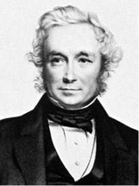
Picture: John Stevens Henslow 1796 - 1861, in about 1850
Anglesey
It still seems extraordinary, as indeed it did to Henslow, that there was at that time no topographic map showing an accurate configuration of either the coastline or the land surface of Anglesey. This must have been a major drawback for his mapping, since neither was there any accurate depiction of the few roads or tracks that existed. It is difficult to appreciate the hard work- especially the ‘field hours’ - that must have gone into this map’s production, considering the lack of any base-map at a scale suitable for geological mapping.
 Henslo
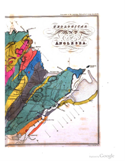 w acknowledges two available topographic maps of north Wales: one by Evans (1797), the other by Furnival, published in 1814. But there was no reliable map of the coastline, where the essential geological outcrop occurs. Evans’s map, he says, was useful in giving the relative position of towns, but “does not pretend to trace the indentations of the coast”. Transport must have been principally by horse but then by foot - especially around the rugged coastline.
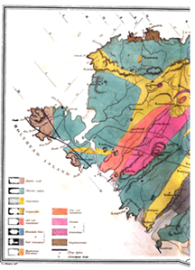
Maps (left and right): Henslow’s map of Anglesey. Colours: brown = quartz rock; green = chlorite schist; yellow = greywacke; red dotted on yellow = serpentinite; orange = Old Red Sandstone; red = granite, greenstone dotted; blue = limestone; grey = Coal Measures; pink = New Red Sandstone; brown dotted = conglomerates
Henslow’s map (left and right), published scale approximately one half inch to the mile, distinguishes eight sedimentary and metamorphic formations: Quartz Rock; Chlorite Schist; Greywacke; Old Red Sandstone; Mountain Limestone; Coal Measures; New Red Sandstone; Conglomerates. It also shows three intrusive igneous types – serpentine, granite and greenstone as well as major dykes. His geological mapping of Anglesey was extraordinary both in its detail and accuracy, using continuous lines for observed geological boundaries and dotted where they were obscured. Naturally, the boundaries of these rock types differs considerably in detail from those on the modern map, although the broad outlines are in good agreement. For a map produced over two years under difficult conditions the result is impressive.
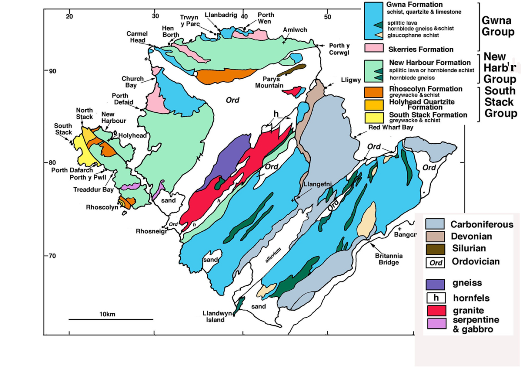
Map (right): A geological map of Anglesey (Treagus 2008)
Henslow’s Memoir
The text of his quarto-size, 452-page Memoir gives detailed accounts of the nature of the various lithologies, which I have attempted to summarise below. I have noted in brackets the modern formation and other names equivalent to some of the terms used by Henslow.
Quartzite. Henslow chooses the term Quartz Rock to differentiate two areas where we would now simply use the term ‘Quartzite’. These are both areas of prominent topography, he notes, one to the north of Porth Dafarch, around Holyhead Mountain, the other around the Rhoscolyn Headland. He notes that this rock contains some feldspar and a little mica and chlorite, resembling greywacke in some places. These areas in part comprise what we now call the Holyhead Quartzite, Rhoscolyn and South Stack Formations of Holy Island.
Chlorite Schist. Although Henslow says that the term Micaceous Schist might be used to include all the oldest schistose stratified rocks, he generally uses the term Chlorite Schist. This schist, he says, in some places succeeds the quartzite unconformably - an interesting early use of this term in the geological literature; but elsewhere, he says, there is a degree of intermixture. Henslow describes in detail the various combinations of chlorite and quartz in the schists and the transitions between rocks that he distinguishes as ‘mica slate’ and ‘clay slate’, in a lower metamorphic state. These areas principally comprise, in modern terms, the New Harbour Formation and Skerries Formation of northwest Anglesey.
Greywacke. These areas mostly comprise the areas of, in modern terms, the Ordovician. The descriptions of the rocks, although detailed, are rather muddled and incomplete. They include principally ‘slate’ and ‘greywacke’.
Structure and metamorphism. There are several points of particular interest in Henslow’s observations of the structure of the quartzite and schists. He notes, for example, that “the greater proportion of the stratified rocks has suffered considerable disturbance”. He illustrates the structure of the anticline in the South Stack quartzite with a very detailed and accurate drawing. This structure, he says, has the appearance of an artificial stone arch that might be produced “by applying a disturbing force to an unconsolidated mass”. The parallelism of the mica (in the quartzite), he says, gives rise to a deceptive appearance “like an imperfect form of cleavage, (sometimes) resembling stratification”.
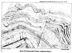 Picture: Henslow’s sketch of the anticline at South Stack
The resemblance that some strata bear to sandstone, he says, points to a mechanical origin; a crystalline force, assisted by moisture and pressure, was of sufficient power to produce the texture of these oldest stratified rocks (my paraphrase), so that they frequently occur with a character very different from that which they would have had in an undisturbed state.
Henslow notes that the “arrangement of the mica” in the schists is parallel to the stratification, whereas in the quartz rock it has “arisen later than the contortions of the strata”. He appears to be saying that the cleavage (not a term he uses) in the quartzite, in contrast to that in the schist, is either later than or contemporary with the folding.
He notes that some strings of white quartz (veins) partake equally with the contortions (folds) in the schists but elsewhere conditions are “more complicated”, where the folds of the veins are independent of (later than?) those in the surrounding mass. He appears to be deducing that there are two generations of quartz veins, pre-dating and post-dating the dominant deformation.
Henslow observes that the average bearing (strike) of the strata is between NE and SW, with dip generally to the NW; but notes some sections have variations and contortions. Much of the text reveals his understandable confusion as to the order of the various areas of schists and their relationship to the quartzite.
Cross-sections, diagrams
The Memoir is illustrated with 22 diagrams, and 13 parallel, NW–SE, cross-sections and two transverse cross-sections. Some of these sections are shown here.
Sections ( below, left) Examples of Henslow’s cross-sections; directed NW to SE. a. Holyhead Mountain (continued to b. below) b. Rhoscolyn (uncoloured schist to left and right; quartzite to centre) c. Llanbabo d. Llanerchymedd
a
b
c

d

Further reading
-
Henslow, J S 1821. Geological Description of Anglesea. Cambridge Philosophical Society XXV1 359 – 448.
- Henslow, John Stevens. Wikipedia
- Treagus J E 2008. Anglesey Geology - A Field Guide pp10 &11 GeoMon, Anglesey
Acknowledgements.
Thanks to Nigel Woodcock for providing a copy of Henslow’s paper in the Cambridge Philosophical Society (1822) and to Sue Treagus for critical reading and suggestions for improvement.