Involving non-scientists in research has a long pedigree in other fields, but uptake is slow and cautious in the Earth sciences. It can be done, says Jonathan Paul: here’s how (and why)
 In December 1900, the American ornithologist Frank Chapman proposed an alternative to Christmas ‘side hunts’ – a tradition in which Americans competed to kill the most birds, regardless of use, scarcity or beauty. What if, Chapman suggested, we count birds instead of killing them? On Christmas Day 1900, 27 observers participated, counting between them 18,500 birds belonging to 90 species. The count has since been held every winter – 2,615 ‘counters’ took part in the 2018-19 event. The Christmas Bird Count was one of the first of what have since become known as ‘citizen science projects.’
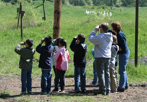
Right: Young bird watchers (wikipedia)
It’s not surprising that citizen science has taken off in recent years. The explosion of new technology following the internet of the 1990s has enabled people to feel more interconnected. In the context of multiple global crises, of which the climate emergency and fallout from the Covid-19 pandemic are arguably the most important, this connectivity has helped us regain a sense of agency over events that perhaps seem frightening, inchoate and difficult to control. Since the term first emerged in the early 2000s, citizen science was immediately recognised as having the potential to mobilise people’s involvement in social action and justice, as well as large-scale information gathering.
Global geoscience
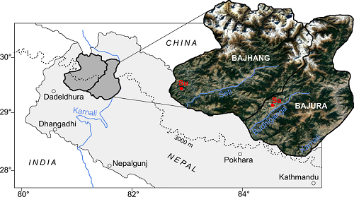 Left: Figure 1. Map of western Nepal, showing the location of two secondary schools for our citizen science interventions (Sa = Saraswati; Su = Sunkuda School).
To what extent does citizen science feature in geoscience? New technology including increasingly sophisticated smartphone apps has enabled citizen scientists to record millions of observations of, for instance, the occurrence of seismic activity (via accelerometers), landslides (from photos and videos), or even air and water quality. Non-scientist engagement in geoscience has perhaps been most pronounced in resilience-building efforts to geohazards. Their motivation for taking part is clear: I will help you take additional measurements to patch up your data gaps, and in return you will provide me with expert advice and information on how to stay safe, whether my family is exposed or vulnerable, and which courses of action I could potentially take in an emergency.
It is important to recognise that our skills as geoscientists are not necessarily sufficient to render such engagement successful and useful. Citizen science is widely considered to be a sub-discipline, to use a cliché, that is very easy to do badly but much harder to do well. Getting it wrong has consequences; it can lead to a lack of trust in the community towards the government or professional scientists.
These days, many large grants disbursed in geoscience by Research Councils assume an implicit high degree of transdisciplinarity. What is now a given – for instance, that geologists will work with social scientists to enhance research impact – was considered rather novel barely five or six years ago.
The challenges of setting up a successful citizen science monitoring programme are numerous. issues range from the need to provide incentives (often money) to participate, to the highly variable quality and fragmentary nature of citizen-collected datasets. The two greatest challenges for geoscientists are quite technical. First, we need to develop strict guidelines through which the uncertainty of data generated by non-scientists can be quantified. How can a lay person assess groundwater level or the clay content of a rock, for example? Such protocols could potentially address the second challenge: how do we convince decision makers (and indeed other geoscientists in academia and industry) of the viability and quality of these data, to the extent that citizen observations can have a real impact on our projects – such as a flood early-warning system or a hydrogeological groundwater model.
To date, relatively few of these projects have been conceived in developing countries, owing to a range of complex and interrelated hurdles including bureaucratic, financial and language barriers, hostile weather, and inaccessibility. There is rich potential in the geosciences to transcend a traditional view of the smartphone-equipped citizen passively feeding data to a central database. Working closely with groups of non-scientists throughout the duration of a research project requires more money, careful thought and intensive collaboration with social scientists. The potential rewards, though, are rich, and could include capturing hitherto hidden local knowledge, permanent reductions in risk against geohazards and improvements in community cohesion.
Lessons from rural western Nepal
 Right: Figure 2. Lesson plan co-developed with local teachers, translated into local Nepali dialect, for our ‘rainfall and rivers’ session.
Over the past five years, I’ve been involved in various citizen science research projects spanning seismology, flood and landslide risk reduction and irrigation management. In 2019, Scientists from Imperial College launched a new initiative that focused on two secondary schools in mountainous western Nepal (Figure 1). The goal was threefold: to enhance science, technology, engineering and maths (STEM) teaching in a developing country context, to produce new geoscientific datasets and to build greater environmental awareness (of, for instance, landslides, rivers and earthquakes) in the new generation of students.
These activities were intended to move beyond any form of ‘outreach.’ After working closely with local communities for several months, we found schools to be the most effective gateway to local people: teachers are often the most educated and respected community members, while students are enthusiastic receptors of new information, which is then transmitted to their parents. Also, schools offer ready-made organisation and a central forum to bring different local stakeholders together, which is comparatively rare, especially in developing countries.
Lesson plans
We started by developing lesson plans (Figure 2) with schoolteachers a priori, whose content would complement the government-prescribed STEM curricula while also introducing new material tailored for local relevance (e.g. determining the degree of cambering on local rice paddies as a result of nearby rotational slumping, or measuring changes in river cross-sectional area and discharge through the Monsoon season).
We worked with graphic designers in Kathmandu to generate visually appealing material such as posters on the water cycle and causes and effects of mass movements (Figure 3). Teaching and question-and-answer sessions were delivered by a mixture of local schoolteachers, European and Nepali scientists, as well as student representatives (Figure 4). Each day included an outdoor practical component where students collected data: in one such experiment, students were trained to collect rainfall data using simple measuring cylinders, which would then be validated against an existing co-located automatic tipping-bucket rain gauge. This exercise, and the students’ data, were used to forge a local link to the broader context of changing patterns of Monsoon rainfall due to climate change (Figure 5).
Throughout our intervention, we sought to treat local stakeholders (mainly students and teachers) as equal partners, producing data of objective scientific value. In so doing we were able to address to question of project sustainability, which is often a major problem in citizen science research. The typically fixed-term funding model in the UK places a constraint on the tractability of scientific questions that can be answered, which can only really be solved by ensuring that community-level monitoring and analysis continues after the funding runs out. In this instance, we attempted to secure this sustainability via weekly meetings with the teachers, and offering community ownership of the automatic rain gauges, new smartphones, and other scientific equipment.
Lessons learned
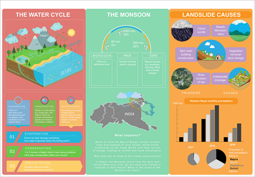 Left: Figure 3. Poster displayed at secondary school in west Nepal used to stimulate discussion about the water cycle and geohazards.
Of course, we learnt many lessons during our series of community interventions in western Nepal; many things that did not go exactly as foreseen or planned. We discovered the importance of being as humble as possible when liaising with local community members. For many this is not a trivial thing to do: academics in geoscience (and other fields) are increasingly accustomed to the necessity of sprinkling CVs with a dusting of h-values, impact factors, and citation metrics. In this instance, ‘humble’ translated to keeping one’s mind open regarding local geological conditions: it should not be so much a case of turning up with pre-conceived and concrete ideas of local environmental challenges (as we did: “you’re having all these landslides because of over-zealous road building”); rather, local knowledge should carefully be incorporated wherever possible.
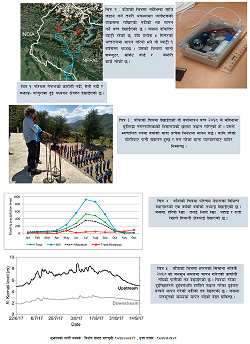
We were presented with shortlists of impossible-to-satisfy problems, such as a locally pressing need to monitor river water quality every 10 cm along a 50 km river (due to contaminant discharge of uncertain origin). We found a good compromise was to present very broad research aims, and scientific possibilities, at the very beginning; for instance, “we would like to understand how much of this river’s flow is fed by an aquifer. Using a lidar sensor is one way of measuring river level – like this – which can then be converted into discharge – like this.” (Figure 6).
Local relevance
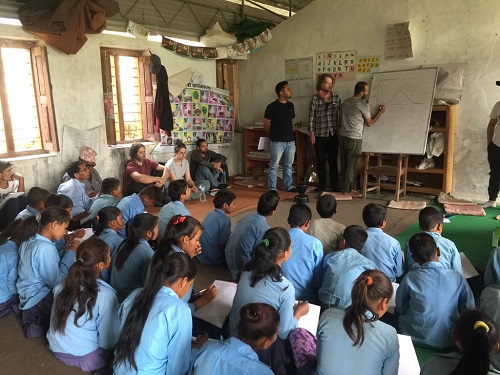 Right: Figure 4. Teaching 45 Nepali secondary school students about groundwater flow.
After the preliminaries and introductions, the next critical step was to understand the motivation of non-scientist participants: why should they care? How would ‘our geoscience’ affect their livelihoods? In geohazard research, the idea that a local community would somehow, vaguely, just ‘be grateful’ for the presence of professional scientists, is a misconception. In many areas that suffer multiple hazards like western Nepal, local people rated their effects very low on the list of priorities; well below more pressing livelihood needs such as ensuring good harvests or raising children. In this sense, we strove to make our research as locally relevant as possible.
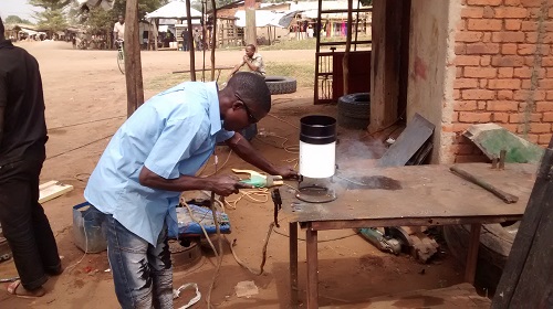
In practice, this was not a straightforward proposition, since our main scientific goal of generating new, spatially dense environmental datasets (e.g. of precipitation, which could then be used to benchmark satellite estimates) was largely irrelevant in the field. Nevertheless, we discovered multiple possibilities. As far as possible, our project team sought to become embedded in the local community: this took the form of using local suppliers or craftsmen to make certain pieces of geophysical survey equipment (Figure 7), having a PhD researcher living in the local community for several months, and even eating communally with the school students and teachers (and sleeping in the school hall). We then began to develop simple-to-operate, low-cost sensors that also had a practical, tangible use, such as river level sensors that reported in real-time to a centrally positioned LED display board. Moreover, in more remote regions where manual data collection was not feasible, we found that engaging local people with a monthly stipend to maintain equipment and/or download and transmit data was an acceptable compromise.
However, our intention was not passive data collection: multiple studies have demonstrated the benefits of involving citizen scientists throughout the entire lifecycle of a research project (i.e. from problem conception to the dissemination of results) in terms of retaining participants and boosting the sustainability of the science. We found that the schoolteachers in particular wanted to become fully invested in our research (to the extent of multiple unsolicited offers to write journal articles summarising our results!) How could it be possible to accommodate this level of engagement?
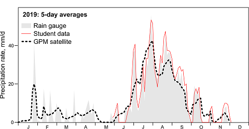 Left: Figure 5. Gauge and student rainfall data for 2019 Monsoon season in west Nepal, versus satellite estimates. The students’ data provides a superior spatiotemporal fit to automatic rain gauge data.
Geoscientists are physical scientists for whom the answer might seem rather imprecise or ‘fuzzy’. Identifying who makes decisions locally, or where local power lies (“institutional mapping”) is a good place to start, involving close and intensive collaboration with social scientists. At each of our study sites, we identified one or two significant people – often a headteacher, community or political leader, who acted as useful conduits to the broader community (often called “social mobilisers” or “community champions” in social science literature). By channelling our interactions through these people, and involving them in all our school activities, we were able to focus discussion on the specific needs and interests of disparate groups of other stakeholders like farmers, local government, or industry.
The future of participation
Delays in the growth of citizen science in the geosciences can be explained by the inaccessibility and complexity of many geological and geophysical datasets (e.g. seismic sections, gravity anomaly maps, borehole logs), as well as the relatively recent development of new technology such as internet connected smartphones. As we found in Nepal, the active involvement of citizen scientists through all stages of a project (rather than just data collection or passive ‘citizens-as-sensors’) can enhance local interest and uptake, therefore increasing the sustainability of the project and reducing its chances of collapse upon the (often inevitable and funding-constrained) withdrawal of professional scientific support.
However, relative to other disciplines like ecology or medicine, the uptake of citizen science has so far been rather limited in geoscience, largely restricted to the monitoring of geohazards like landslides and volcanoes. Geophysical data are often difficult to interpret intuitively, while measurements tend to be expensive (e.g. using proprietorial software), complex, spatially sparse and temporally dense (for instance, long time series of groundwater flow).
For these reasons, intensive scientific training and specialisation is still normally a prerequisite for data analysis and manipulation. However, new technological developments can, to some extent, circumvent these limitations, paving the way for the more rapid uptake of citizen science. On the other hand, geoscientists should recognise that the introduction of new smartphone apps is not a universal panacea: encouraging uptake of these apps is challenging, and many app-based projects have fared poorly as there are often few material incentives for participating.
Equal partners
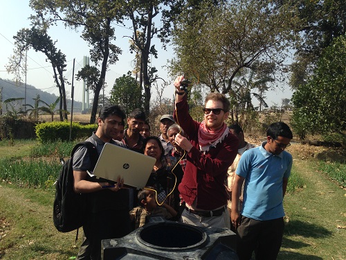 Right: Figure 6. Demonstrating a low-cost real-time water level sensor to village farmers, Chisapani, west Nepal.
While the exact form that citizen science takes varies widely – and there is some debate over whether all projects that include non-scientists in scientific work constitute citizen science – timely and accurate information can greatly assist geoscientists in completing research projects. Especially in developing countries like Nepal, the future of citizen science lies in moving away from monitoring campaigns for geohazards towards a new model, in which non-scientists are equal research partners who identify and help to solve local objects of research interest. These could involve observational campaigns (e.g. finding and documenting new springs, ore-bearing rock, or mass movements), community-level risk reduction and resilience building, or education (e.g. learning how to code while analysing locally collected seismological data).
The participatory approach has been shown to work best when there is active interest from the local community. That is, the benefits to local people must be highlighted. In our case in Nepal, this included enriched STEM teaching for local students, improved real-time monitoring of rivers and rainfall and the potential for predictive models that could decrease risk to landslides and flooding in the future. The best projects have their aims and objectives defined at the outset; project members have appropriate expertise (not just scientifically, but also in publicity and communication); and there must be a clear willingness to listen and adapt as necessary.
Author
Dr Jonathan D. Paul (FGS) is a Lecturer in Geoscience at the Department of Earth Sciences, Royal Holloway, University of London, UK (email: [email protected])
Acknowledgements
Funding is acknowledged from the UK Natural Environment Research Council (NERC) and Department for International Development (DfID) under contracts NE/P000452/1 (Landslide EVO project) and NE/P016952/1 (CARISMA project).
Suggestions for further reading
- Paul J.D., D.M. Hannah and W. Liu. Editorial. Citizen science: Reducing risk and building resilience to natural hazards. Frontiers in Earth Science, 7, 320, 2019.
- Editorial, Rise of the citizen scientist. Nature, 524, 265, 2015.
- Paul J.D., W. Buytaert, S. Allen, J.A. Ballesteros-Canovas, J. Bhusal, et al. Citizen science for hydrological risk reduction and resilience building. Wiley Interdisciplinary Reviews: Water, 5, e1262, 2018.
- Irwin A., No PhDs needed: How citizen science is transforming research. Nature, 562, 480–482, 2018.
Below: Figure 7. Community blacksmith making a tipping-bucket rain gauge stand.