Product has been added to the basket
Articles

Bruce Yardley appointed Chief Geologist

Bruce Yardley (Leeds University) has been appointed Chief Geologist by The Radioactive Waste Management Directorate (RWMD) of the Nuclear Decommissioning Authority (NDA).

Chartership news

Chartership Officer Bill Gaskarth reports on a projected new logo for use by CGeols, advice on applications and company training schemes

Climate Change Statement Addendum

The Society has published an addendum to 'Climate Change: Evidence from the Geological Record' (November 2010) taking account of new research

Cracking up in Lincolnshire

Oliver Pritchard, Stephen Hallett, and Timothy Farewell consider the role of soil science in maintaining the British 'evolved road'

Critical metals

Kathryn Goodenough* on a Society-sponsored hunt for the rare metals that underpin new technologies

Déja vu all over again

As Nina Morgan Discovers, the debate over HS2 is nothing new...

Done proud

Ted Nield hails the new refurbished Council Room as evidence that the Society is growing up

Earth Science Week 2014

Fellows - renew, vote for Council, and volunteer for Earth Science Week 2014!  Also - who is honoured in the Society's Awards and Medals 2014.

Fookes celebrated

Peter Fookes (Imperial College, London) celebrated at Society event in honour of Engineering Group Working Parties and their reports

Geology - poor relation?

When are University Earth Science departments going to shed their outmoded obsession with maths, physics and chemistry?

Nancy Tupholme

Nancy Tupholme, Librarian of the Society and the Royal Society, has died, reports Wendy Cawthorne.

Power, splendour and high camp

Ted Nield reviews the refurbishment of the Council Room, Burlington House

The Sir Archibald Geikie Archive at Haslemere Educational Museum

You can help the Haslemere Educational Museum to identify subjects in Sir Archibald Geikie's amazing field notebook sketches, writes John Betterton.

Top bananas

Who are the top 100 UK practising scientists?  The Science Council knows...

April 2012

Trendall

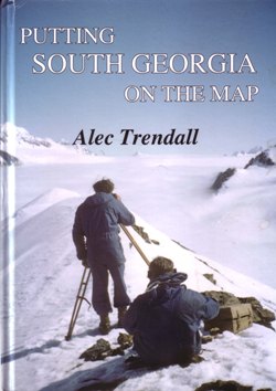
Putting South Georgia on the Map

Geoscientist 22.03 April 2012

The line “South Georgia rising out of the ocean, like a misplaced section of the Alps” epitomises this book, which it was intended should be written by Duncan Carse, who organised and led three private expeditions to South Georgia in the 1950s. On his death the task devolved on AlecTrendall. This is an important record, which otherwise might have been lost, of the island named by Cook, visited by Bellingshausen, and made famous by Shackleton’s epic boat journey and overland traverse.

The book commences with a historical introduction, leading on to a summary of Duncan Carse’s early life as an apprentice on Archibald Russell, Discovery II, RNVR service (WW2) and his ‘master plan’ to be a polar explorer and lead a trans-Antarctic Expedition. It covers the 1949 attempt to organise a small South Georgia expedition and its fruition (with RGS and SPRI support), leading to the 1951-52, 1953-54 and 1955-56 expeditions, with a primary object to map the entire island.

The next section is written by Walter Roots (pp38-66) and covers the 1951-2 expedition. It is emphasised that in such a little-known area, geological survey work had to be kept simple: recording information of rock composition and structure, in as much detail from as many localities as possible. The basic tools were hand-lens, compass, clinometer, notebook, camera, geological hammer. Collecting samples for laboratory study was important, especially fossils for dating. At the time, rock-dating meant superposition and biostratigraphy: radiometric methods were not yet available.

The second expedition (pp71-90) was bedevilled by Duncan Carse’s deterioration, due to the failure of his marriage and worries about the Trans-Antarctic Expedition, as well as his quarrel with Gordon Smillie. Keith Warbuton was ill and never contributed. But Alec, though still lame, performed much valuable geological observation - especially in the complicated developments at Wirik Bay. By the end of the second season they established that the island was largely composed of Mesozoic (Cretaceous) turbidites (greywackes); though there are also granitic rocks, gabbros, lavas and two sets of dykes cutting everything else in the south east. Trendall’s geological map contributed to the decision of the British Antarctic Survey to begin a detailed geological study of South Georgia in 1969.

The third expedition is described at second hand: the party completed the topographic survey of the island with no acrimony. Appendices cover ‘The men of the South Georgia Surveys’; sources; glossary; Shackleton’s route. This is a splendid, superbly illustrated, book and should be widely read.

Joe McCall

PUTTING SOUTH GEORGIA ON THE MAP
ALEC TRENDALL (WALTER ROOTS)

Published by the author, 2011. ISBN: 978-9870614-0-9 (hbk) 978-9870614-1-6 (pbk). 216 pp Price: Hbk A$50 in Australia (A$60 elsewhere). Pbk A$40 (A$50 elsewhere). Signed copies: A$80 in Australia (A$90 elsewhere).
www.alectrendall.com.au


G&G

Granite and Grit – A Walker’s Guide to the Geology of British Mountains

The large format of Granite and Grit and the quality of its colour illustrations make this book deserving of a place on anyone’s coffee table. Equally, the objective of giving the lay-walker a taste of the geology that he or she might encounter as they are striding out across Britain’s mountain wilderness is an admirable one. However, that commendable aim is only partially satisfied as the book ultimately is neither a walking guide nor a geological field guide. But it does say a lot about the foundation that provides such terra firma beneath the battalions of walking boots that cross hillsides and scramble over such famous rocky icons as the Great Slab of Langdale and even the Etive Slabs.

Therein lies the real substance of this work, for Turnbull pays homage to the umpteen types of rock that serious walkers will encounter during their upland explorations. From granite to gneiss, sandstone and shale, limestone, lava and grit - all are dealt with in Turnbull’s knowledgeable and sometimes humorous prose, drawing on his own walking experiences throughout the UK and around the world.

Along the way the geologically uneducated will learn why Cuillin gabbro is such a pleasure to clamber over, what befell the landscape when the volcanoes of Borrowdale and Glencoe were spewing out their molten innards, and which continents collided to crumple the metamorphic strata of the Southern Highlands. But rather than providing a step by step geological account, Turnbull gives us a broad sweep of the lithological brush, province by province, and colours his account with references to the mountains he has climbed – and there have been many – and the routes he has taken.

As a purist, I was a little disappointed that the telling is so geologically general; I wanted more detail and I suspect that much of the GSL readership will feel the same. After all, the underlying theme of the meeting of continents to bring England/Wales together with Scotland, and that new land’s subsequent geologic evolution is not new to most members. However, to the lay-person, and especially the lay-walker, for whom this guide was written, it is something new to add to the countless conventional guides and maps now gathering dust; something to inspire a new perception of Britain’s high ground perhaps.

Sean Mulshaw


GRANITE AND GRIT – A WALKER’S GUIDE TO THE GEOLOGY OF BRITISH MOUNTAINS
RONALD TURNBULL

Published by: Frances Lincoln Limited, 2009 (pbk 2011). ISBN: 978-0-7112-3180-1. 208 pp. List price: £16.99
www.franceslincoln.com