Gary Nichols* makes the case for field-based training in the oil and gas industry, and why it is integral to achieving and maintaining Chartered status.
 In 2014, this magazine’s ‘Soapbox’ column (and, subsequently, the Letters pages) hosted a kind of spontaneous flashmob discussion of the role of fieldwork in the teaching of geology. The attraction of working outdoors may not be for everyone; but the question of assessing the relative value of ‘seeing rocks in the field’ against seeing them via the medium of a computer screen, remains.
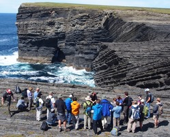
Picture: Examining a deep-water succession on a field course in County Clare, Ireland (Photo Nautilus Ltd: course N009)
There is no doubt that remote-sensing, virtual reality outcrops and rapid geochemical analysis have all significantly improved our ability to understand the Earth. This increasing use of technology in our science has started to shift the emphasis away from observational field studies, and thus the case for continuing to send geoscientists into the field has to be made with specific, tangible (and, yes, economic) arguments. This article will focus on petroleum geoscience; but similar points could be made about other strands of our science.
Employment
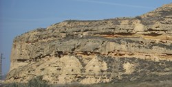 Picture, right: Fluvial channel sandstone bodies with a sheet-like geometry. Compare with pic below.
Every year, hundreds of students with BSc, MSci, MSc and PhD degrees from UK universities seek employment in the oil and gas industry. Their preparation for a job will probably include a first degree in which a number of weeks spent in the field were a compulsory element of the programme, providing them with awareness of a wide range of geological phenomena.
A specialised Masters degree will also have included some field courses, but few will have undertaken a field-based project. To help encourage more MSc students to include fieldwork, CASP (a research organisation based in Cambridge, specialising in field-based studies for the energy industry) offers an MSc student scholarship that includes a fieldwork bursary.
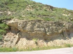 Picture, left: lens-shaped sandstone bodies formed by river channels. Both outcrops are from the Miocene of the Ebro basin and illustrate sandstone geometries that would behave quite differently as reservoirs. (Photos Nautilus Ltd: course N108)
The proportion of field-based PhDs has decreased over the years - partly due to funding pressures, but mainly due to trends in academic research, which have shifted in emphasis towards more instrument-based topics. However, the recent creation of the NERC Centre for Doctoral Training in Petroleum Geosciences (Heriot Watt University – see below) will help to ensure that students who do their PhDs under this scheme will have the benefit of a series of field courses as part of their training.
Industry training
What is important, when these students enter the industry, is that field training remains integral to their Continuing Professional Development. The oil and gas industry has a good record of providing on-going training to their professional staff (see Letters, p. ??). This has been made evident over the past year, during a period of falling oil prices. Most companies have maintained a programme for their staff (albeit scaled back). Very few have stopped training geoscientists altogether, while some have increased their commitments, despite having laid staff off.
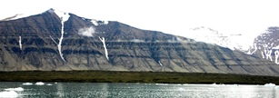 Picture, right: Stratal geometries from the Cenozoic of Spitsbergen (a) Mountainside clinoform exposure at Storvola. Compare with next picture.
To quote a particularly enlightened company: ‘We now have to operate with fewer people, so they need to be better trained’. Budget constraints have resulted in travel restrictions, so attendance on field courses across the Atlantic has become rarer; but many hundreds of oil and gas company geoscientists are still attending field-based training courses this year. The message is clear: despite all the uncertainty, doom and gloom of an oil price half what it was a year ago, CPD training is still valued in the industry, and field courses still have a place.
 Picture, left: details of slope facies (Photos Nautilus Ltd: course N298)
This raises the question of why field-based training is seen to be important for professional geologists in the industry – important enough to be paid for, even as budgets are being cut. The answer lies in the technological advances that have been made in the last couple of decades: not in what these new technologies can do but in what they cannot.
As a result of advances in data processing, 3D seismic now provides imagery of the subsurface in a degree of detail unimaginable just a decade or so ago. However, the resolution is limited to tens of metres vertically and horizontally, meaning that anything at the scale of metres cannot be characterised. The quality of down-hole data from conventional well-logs and borehole imagery has similarly improved and, along with core, provides detail at the sub-metre scale, but only in the vertical dimension.
Limitations
The limitations of seismic and borehole data become apparent when attempting to create a model, conceptual or numerical, of a body of rock that may be an oil or gas reservoir. The heterogeneities that will determine how a fluid will flow through it exist at a scale that cannot be resolved on seismic data, and horizontal complexities cannot be extrapolated between boreholes that may be kilometres apart. The only way to conceptualise reservoir characteristics is to use analogues from outcrops of comparable depositional setting.
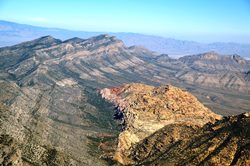 Picture, right: Large–scale structural relationships in Nevada (Keystone Thrust) (Photo Ken McClay, Nautilus course N016)
The problem then is deciding which analogue to use. Taking an example of fluvial channel sandstones: is it better to use the sheet-like sandstone geometries as an analogue, or assume that the sandstone occurs in lenses (see pictures)? Both of the examples shown are outcrops of Miocene fluvial strata from the Ebro Basin (N. Spain). Seeing these two outcrops, along with many others, on a field course focusing on the characteristics of fluvial depositional systems does at least provide a reality-check on reservoir models.
Seeing the units filling a sedimentary basin in the field, allows you to appreciate their geology at a wide range of scales. The sandstone units of a potential reservoir can be examined at a metre and sub-metre scale when standing in front of a rock face; samples can be viewed with a hand-lens, allowing characteristics at and below millimetre-scale to be observed.
Looking away, lithological units that are laterally equivalent, or stratigraphically above and below can be seen, and in areas of good exposure the geometrical relationships over kilometres traced, perhaps across large swathes of country.
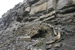
Where exposure is especially good, it is possible to make direct links between what can be seen on a seismic scale, and the scale of an outcrop. This is the case in Cenozoic strata on Spitsbergen where a spectacular mountainside exposure shows a clinoform structure (picture). Most importantly, it is possible to traverse the whole structure and see the clastic facies variations from marginal marine to slope deposits, with their small-scale soft sediment deformation.
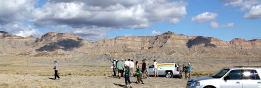 Picture, left: Extensively exposed shoreface facies in the Book Cliffs, Utah. (Photo Nautilus Ltd: course N011)
Deepwater successions are exploration targets in many parts of the world, so it is important to see large-scale facies relationships in the field - in places like the Karoo (South Africa). Other examples include the complex fold and thrust geometries in the Spanish Pyrenees and French Alps, and their controls on stratigraphic relationships; or exposures of shallow marine facies and their sequence stratigraphic relationships traceable for tens of kilometres in the Book Cliffs of Utah.
Any geoscientist who sees geological features in the field like this will come away with a better understanding of the processes that produced them, and thus better equipped to interpret subsurface data.
No stopping
Evidence of continuing training is an important criterion in attaining and maintaining Chartered status (CGeol). For petroleum geoscientists a widely-held consensus within the industry holds that field-based training is a fundamental element of CPD, from learning core concepts in graduate programmes, to advanced, specialist courses for those with a decade or more’s experience.
Trotting out H H Read’s dictum that the ‘best geologist is the one who has seen the most rocks’ (see Letters, p. ??) is no longer enough; but it is easy to provide tangible examples of how experience of seeing geological features and relationships in the field can significantly enhance a geoscientist’s ability to do his or her job in oil and gas. Seismic and borehole data can provide opportunities for sophisticated interpretations of the subsurface. Those interpretations, however, need to be reality-checked by comparison with rocks in the field and the scale limitations of these data recognised through seeing the complete picture - in outcrop.
*Gary Nichols is Managing Director, Nautilus Ltd (part of RPS Group). Nautilus is the largest single provider of field-based training for geoscientists in the oil and gas industry. The programme of geology, geophysics and professional skills development courses offered by Nautilus is accredited by the Geological Society and can form part of a development pathway to achieving Chartered status.