Product has been added to the basket

Glimpses of the past

John Powell*, Gemma Nash and Patrick Bell urge everyone to get logging with the new citizen science web site hosted by BGS

Geoscientist Online 19 October 2011

The geological community in the UK has long recognised that scientifically important information revealed in temporary exposures of bedrock and superficial Quaternary deposits is frequently lost to science. This is largely due to the ephemeral nature of the exposures and the inability of the geoscience community to respond at short notice.

The Geological Society Stratigraphy Commission has for many years recognised that geological information seen in temporary exposures may provide highly valuable information that is not recorded, archived and made available to all. In discussions at the Commission, we recognised that a vehicle was needed to expedite the recording and storing of information observed in pipeline trenches, shallow excavations, road cuttings and embankments.

This initiative was taken forward at the British Geological Survey (BGS), where the geological imperative coincided with a wish among the BGS web development team (Patrick Bell and Gemma Nash) to develop a ‘citizen science’ website – GeoExposures (Figure 1, below). Powered by the new ‘Ushahidi’ crowd-sourcing software that was developed to assist with communicating events during major emergencies such as the Haiti earthquake (‘ushahidi’ is Swahili for ‘testament’), GeoExposures is concerned only with the recording of temporary exposures. It is not aimed at documenting natural exposures (inland and coastal cliffs, disused quarries etc.), nor with the conservation of geological sites1. (The BGS Citizen Science website also incorporates reporting of landslides, flood events and soils.)


Figure 1. GeoExposures web page: britishgeologicalsurvey.crowdmap.com

Figure 2. The first GeoExposures record submitted by Andrew Hunn showing minor faults in the Upper Triassic Branscombe Mudstone Formation recorded in a pipeline trench near Tirley, Gloucestershire (Worcester Graben).

AMATEUR & PROFESSIONAL

Using the GeoExposures web site, amateur and professional geologists will be able locate a temporary exposure on a Google map, briefly log the site geology on a pro-forma , and upload .jpg photo images to the web site either via a smart phone or from their home or office computer. Some users may prefer more traditional methods to map, log and record - using notebook, hard copy Ordnance Survey maps or BGS geological maps - and subsequently upload at their convenience from a computer. The essential ingredients will be accurate descriptions and good quality digital photographs as a permanent record.

Image: Figure 2: The first GeoExposures record, submitted by Andrew Hunn, showing minor faults in the Upper Triassic Branscombe Mudstone Formation recorded in a pipeline trench near Tirley, Gloucestershire (Worcester Graben).

To assist recording, the web site provides the user with links to background information on the geology and stratigraphy of the UK such as digital BGS geological maps, the BGS Stratigraphical Lexicon and the BGS Timechart. In addition, there is a converter to transfer latitude-longitude locations gleaned from a Google image to British National Grid. The pro-forma site description can be supplemented by additional information such as a site sketch map and geological log - these can be drawn freehand, and submitted as scanned .jpg images.

Figure 3. GeoExposures web site example showing the Upper Triassic Branscombe Mudstone Formation exposed in the excavations for the William Smith Building, BGS, Nottingham in 2008.

FIRST RESPONSE

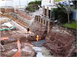
During development of a ‘beta’ test site we received an email from Andrew Hunn, an archaeologist, who was logging a pipeline trench near Tirley, Gloucetershire. Andrew’s images and site description became the first external GeoExposures record (Figure 2, above left). Coincidentally, the faulted Mercia Mudstone (Upper Triassic) exposure is the same age and formation as our example site based on exposures of the foundations of the William Smith Building at BGS Keyworth. We hope ‘the father of English geology’ would approve of the latest format for recording geological information. (Meanwhile, Andrew Hunn reports that he has 14 years of pipeline records that may be of interest…!)

Image: Figure 3. GeoExposures website example showing the Upper Triassic Branscombe Mudstone Formation exposed in the excavations for the William Smith Building, BGS, Nottingham in 2008.

We are keen to see this website as a geoscience community site, rather than an ‘official’ BGS site. Our vision is to deploy the software in a usable format for common access and as such, Geoexposures is made available under a Creative Commons licence. We hope that professionals in the civil engineering and quarrying industries will also be keen to submit records of short-lived exposures at their sites. BGS will monitor submissions for improbable records (dinosaur tracks in Cambrian mudrocks… graptolites in Carboniferous shales, etc.), but we do not intend to rigorously verify the records. Comments and suggestions can be sent in, and indeed we hope that GeoExposures will generate vibrant discussions. We envisage that any scientific publications arising from GeoExposures records will duly acknowledge the source material.

Finally – we would stress that permission to enter onto sites (actual, as well as virtual) remains entirely the responsibility of the individual, as is health and safety. So, please give it a go - and get logging!

REFERENCES

  1. For further information on natural exposure recording see Natural England (http://www.naturalengland.org.uk/), Scottish Natural Heritage (http://www.snh.gov.uk/), Countryside Council for Wales (http:/www.ccw.gov.uk/) and the GeoConservationUK (http://wiki.geoconservationuk.org.uk/).

*BGS and Geological Society Stratigraphy Commission [email protected]