520 million years ago, much of the Earth’s continental landmass existed as two large continents, Gondwana and Laurentia, separated by 7,000 km of ocean. What is now the UK was separated between them – the north of Scotland on Laurentia, and the rest on Gondwana. The two were joined during the Caledonian Orogeny.
During the Caledonian Orogeny several mini-continents (including Avalonia and Baltica) that had broken off from Gondwana were joined to Laurentia by tectonic plate movement, forming a new landmass. It was a long process, taking about 150 million years, and occured mainly between the late Cambrian (490 million years ago) and mid Devonian (390 million years ago).
The main ocean between the colliding plates, the Iapetus Ocean, was subducted. During the Cambrian, it was subducted to the north, beneath Scotland, and to the south, beneath Anglesey and North Wales. During the Ordovician, it was subducted beneath the Lake District.
Evidence in the UK
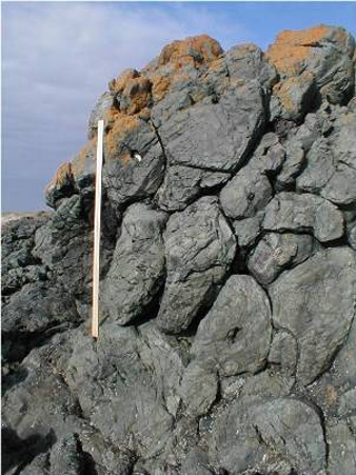
Fig 1: Pillow lava formed by an underwater volcanic eruption of lava at a mid ocean ridge and scraped onto the continental crust during subduction. (Anglesey)
Image courtesy of Pete Loader.
The subduction of the Iapetus Ocean formed volcanoes, whose ash deposits can still be seen in Anglesey and the Lake District.
Major plutonic intrusions (granites) are now exposed by erosion in Scotland, Northern England and Anglesey.
During the subduction, parts of the Iapetus ocean crust were scraped onto the continent, represented by pillow lavas in Anglesey and Ballantrae in Scotland, which had formerly been on the ocean floor. (See fig 1.)
At Girvan and Moffat (southern Scotland), fossil evidence including trilobites and graptolites, indicates a former shallow and deeper water environment. There is also evidence of this environment from the rock record - greywackes were deposited in the deep waters of the subduction trench, whilst black shales were deposited further out on the deep ocean floor (abyssal plain). In North Wales and Anglesey, underwater currents repeatedly deposited sands and clay in deep water.
These sands and clays were later regionally metamorphosed to quartzites and schists by the effect of heat and pressure as these ocean sediments were folded. Slates and gneiss are also evidence of the high pressure and temperatures that caused the clay to metamorphose as mountains were formed.
The collision resulted in a series of large mountain ranges, extending from what is now Scandinavia through much of north and west Britain and into North America. In Britain, the mountains have a NE – SW trend. Although much was eroded away by the end of the Devonian, evidence of these mountain ranges can still be seen in the Scottish Highlands, the Lake District and North Wales.
The plate collision also caused faulting of the rocks. In Scotland, the largest effect of the Caledonian Orogeny is the Great Glen Fault, a former transform fault over 300 miles long which now contains Loch Ness. Other Caledonian faults include the Moine Thrust, Highland Boundary Fault and Southern Uplands fault. It is the NE-SW trend of these faults and fold structures that provides the evidence for the collision of the plates from the NW-SE.