Recent Advances in Solar Park Geotechnics - 7 Sept 2016
 John Hall gave a presentation on Recent Advances in Solar Park Geotechnics developed by South West Geotechnical Ltd. The meeting was held at The Ley Arms, Kenn on Wednesday 7 September 2016 with a good attendance of 33 people
 The talk introduced the growth of the solar industry in the UK over the past 10 years, which was largely initiated in the South West of England, and in which South West Geotechnical became heavily involved with various frame manufacturers and developers at an early stage.
Geotechnical issues that are unique to solar parks were discussed, and highlighted the principle requirement to ensure that post-driven piles that support the frameworks are properly designed to resist downward, lateral and in particular, upward wind forces.
The various methods of estimating required depths to satisfy these requirement were discussed and their merits assessed.
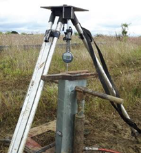
It was demonstrated that by carrying out full scale pile tests using controlled hydraulic test equipment, pile performances can be very accurately assessed, and pile depths can be optimised more precisely than by computer modelling using laboratory and in-situ strength tests.
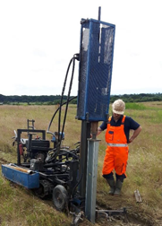
A case study of the 74MW Shotwick Solar Park on Deeside was presented, and used to highlight the general investigation and testing process adopted by SWG. The study also demonstrated the advantages of using the individual test pile’s ‘ramming time’ to monitor small changes in soil strength across the site, which was later adopted as the checking procedure for the acceptability of piles at construction stage. 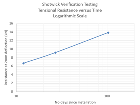
The size and scale of this 224 acre site allowed a testing exercise over a fifteen week period, enabling the observation of how pile performances increased with time, and a time/ strength relationship to be measured. The speed of most solar development projects does not normally enable the luxury of such time-dependant information.
The talk also showcased how short sections of post-piles can be installed and tested using an adapted window sampler rig, enabling likely pile performance to be cost-effectively assessed at site investigation stage, ahead of full scale pile testing.
Rosevale Mine Visit - 2 July 2016
Venue: Rosevale Mine, Cornwall
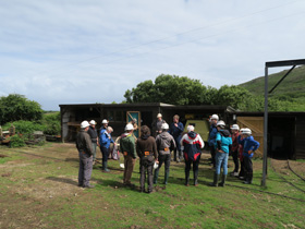 Society members headed to the far west of the region to visit Rosevale Mine near Zennor, to explore the old workings of an archetypal west Cornwall tin mine.
The site is privately owned by the Rosevale Historical Mining Society – former miners and volunteers who have worked to restore the underground workings. They also provide an excellent and comprehensive tour around the underground workings, explaining the history of the mine, how mining methods evolved throughout the mine’s life, and of course, the geology of the area.
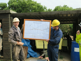
On arrival, Tony Bennett (of the RHMS) introduced the group of 18 whilst getting kitted out with lamps and hard hats. He explained that there are 18th and 19th century records of mining in the area, but they would have been only very small scale workings using primitive methods. Investment in the mine in the early 20th century brought about further exploration and the installation of a processing mill. However, work was suspended with the outbreak of WWI and never restarted.
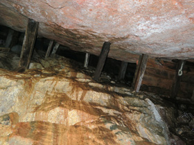
The tour began up the hill, entering the mine at the No.1 Level porthole, and following the drive until it intersected the lode. The mine is situated in the northern lobe of the Land’s End Granite, and the mineralisation is hosted by coarse grained biotite granite with K-feldspar phenocrysts up to 8 cm in length. The granite was quite kaolinised in places, especially where fluids from the mineralised veins had penetrated the surrounding granite. The mineralised veins followed fractures in the granite, trending ENE-WSW. They and are up to 1 m wide and contain 5-8% tin in places. The predominant visible minerals present are tourmaline, quartz and chlorite. Once the drives intersected these lodes, they followed them along strike for their duration.
As we followed the lode westwards along No.1 Level, markings on the wall were pointed noted, left behind from the miners who drilled and blasted the tunnel. The holes were hand drilled, using hammers and steels, and then black powder was used to blast away the rock face. This method saw approximately 6 inches of progress a day, which makes you appreciate the effort that went in to driving these tunnels 300 metres in to the hillside.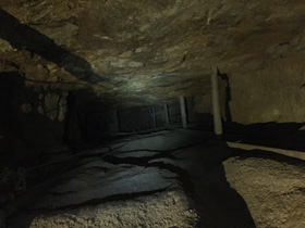
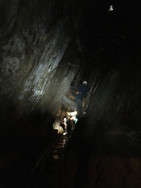
We then descended down the main stope using the ladderway. Stoping was the main method to extract the lodes. By driving a tunnel along the lode, the vein material in the roof above was then extracted. Waste material was dumped below as backfill, and the ore material was taken out along the drive to the surface. This method leaves a cavernous void in the mine, stabilised by pillars left during extraction and wooden beams.
After the two and a half hour underground tour, we exited the mine out of the No.2 Level porthole. Time was allowed for the group to look at the old dressing floors and the mine dumps for any mementoes.
Thanks to Tony Bennett and the volunteers at Rosevale Mine for accommodating this trip by the South West Regional Group and providing a brilliant tour of the mine.
Thanks also to Camborne School of Mines for providing the lamps for the group.
An Audience with Sarah Fray - 26 May 2016
Venue: Plymouth Lecture Theatre, Plymouth University
Sarah Fray, the new executive secretary of the geological society, gave the regional group an interesting and inspiring talk on 26 May at Plymouth University. After being told as a child that 'girls don't do geology' she went on to study engineering at Plymouth, when it was a small institution of just 3500 students.
A job, as essentially a geotechnical engineer, followed involving lots of site investigation. Subsequently, Sarah took up the role of director of engineering at the ISE where she realised that you could influence things and make a difference through professional bodies. When asked to apply for the Executive Secretary role she thought 'that sounds interesting!'
Sarah also gave us an overview of changes made and planned for the society, including changes to the council, my GSL, the new 2017 - 2027 strategy and diversity planning. We thank Sarah once again and hope to see her again in the SW soon!
Near Surface Geophysics as used in Geotechnical Site Investigations - 20 January 2016
Venue: Portland Square Stonehouse Lecture Theatre
Simon Hughes of Terradat came to the South-West and gave us a very thought provoking talk about the use of near-surface geophysics techniques for site investigation purposes. His talk was very much aimed at the industry professional as he talked the audience through the range of geophysical techniques frequently used by the ground engineering professional.
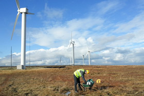
He gave a balanced overview of the techniques, as he weighed up the advantages, considerations and caveats of geophysics, and punctuated his entertaining talk with anecdotes and case studies of previous projects. His case studies included; foundations of windfarms, hidden mineshafts and ground investigations for a new highway.
Simon stressed the importance of the client-contractor relationship and that communication between parties is vital. He clearly showed the added value provided by geophysical techniques due to the rapidity and increased coverage that the techniques achieve
Dawlish Rail Slope Stability Works - 22 April 2015 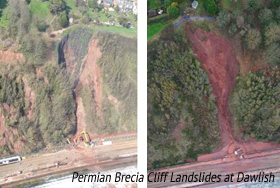
Venue: The Ley Arms, Kenn
Mr Nick John, Network Rail’s SW Route Asset Manager for Earthworks gave a talk about two failures of the Permian Brecia cliffs next to the railway track at Dawlish that occurred in 2012 and 2014.
The 2012 event was first identified in November 2012 after 208mm monthly rainfall, 152% of the long term average (LTA). This composite landslide comprised a series of small incremental slides topples and falls of very weak weathered breccia and overlying gravels around a pre-existing failure bowl on the the upper cliffs. The displaced debris accumulated in the floor of the bowl and following intense rainfall formed a series of debris flows down a gulley through the lower cliff to accumulate at the cliff toe next to the rail track. This resulted in limited line closure to clear the material.
Remedial measures included stabilisation of the bowl on the upper cliff by installation of 250 10m soil nails and 16 horizontal drainage holes. Ground water discharge and runoff is collected in a drainage system that discharges into the sea.
The 2014 failure was a 70m wide block slide of the cliff line just west of the 2012 failure.It occurred in February after 301mm monthly rainfall, 188% of the LTA. Initially creep and heave movements were noticed track side at the toe of the cliffs and subsequent aerial survey using a drone helped identify the extent of the failure.
A 5m high main scarp had developed below the cliff crest and ongoing creeping movements were recorded over the following month. Remedial measures comprised reduction of the failure mass by about 25,000 tons (some 50%) using china clay water cannon monitors to erode loose weak material. The landslide then stopped moving allowing the track to be reopened.
The long term stabilisation of the area was achieved by installing 20m soil nails through the failed block with continued monitoring. The talk was very effectively illustrated with slides and aerial video footage from the drone.
Chartership Talk for South West Regional Group - 4 March 2015
After the Geological Careers day at Plymouth University, Bill Gaskarth presented a comprehensive talk encompassing everything from the origins of the chartered geologist, to hints and tips on getting your chartership approved.
Key questions to ask before starting on the road to chartership are relayed:
- Are you a fellow?
- Do you have 5 years of practice?
- Are you ready?
- Which is more applicable to your career and background - CGeol or CSci?
He also strongly advocates talking to your line managers and arranging sponsors well in advance, so that they can read your application and give you advice that you can act upon.
Once you are ready and have found your sponsors, you will need to carefully select a maximum of 6 supporting documents for your application. Bill stressed that these did not need to be solely written reports but could encompass other material demonstrating your competencies – such as cross-sections, interpretative models etc. Your CPD is also important here and should be kept up-to-date not only with training courses, but other development activities like reading, presenting material, mentoring colleagues and on the job learning. All of which of course should be reflected upon in the record.
The final stage of the application consists of a 15 minute presentation and a 1.5 – 2 hour interview by the scruntineers.
Two interesting points arose from this last part of the talk; firstly, that if there are 12 + applicants from the region, a local interview (potentially Bristol/Exeter) could be arranged to save travel up to London. Secondly, the SW Regional group early careers meeting would be a prefect venue for practicing the 15 minute required presentation. If you are interested in either of these opportunities then please contact the SW Regional group committee.
Finally, Bill made us aware that there are travel scholarships available from the Geological Society for people trying to become chartered or just chartered.
Talk on Mass Extinction - 12 May 2011
Dr Richard Twitchett gave a fascinating talk on Mass Extinction at a new venue for the regional group - Torquay Girls' Grammar School. The school is a school affiliate of the Geological Society and has a vibrant Geology Club.
The talk looked at how we are able to define a mass extinction. This was followed by a detailed overview of the work that Dr Twitchett has undertaken on the "big one" - the Permian-Triassic extinction and recovery: The mass extinction event at the end of the Permian Period was the most severe such event of the Phanerozoic. Dr Twitchett explained how gaining an understanding of the causes and consequences of the end-Permian extinction event is crucial to understanding the evolution of the Earth's biosphere. He also discussed the work he has undertaken on the Lilliput effect: a term which describes the temporary appearance of small body size in animals in the aftermath of extinction events. This phenomenon is widespread, occurs after most biotic crises, but is relatively little studied. He explained that assuming that the Lilliput effect is not the result of bias in the fossil record, then it must reflect a real biological response to changing environmental factors.
Perhaps a message is not to be a specialist and don't get too big!
We are extremely grateful to the management team at Torquay Girls' Grammar School, who provided an excellent set of refreshments and we look forward to building on this new and exciting relationship.
Pictured are Dr Richard Twitchett (University of Plymouth), Mr Gordon Neighbour (Torquay Girls' Grammar School), Dr Mark Anderson (University of Plymouth) and Miss Bethany Dove (Torquay Girls' Grammar School).
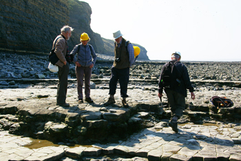
Lilstock Field Trip - 17 April 2011
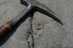 The South West Regional Group of the Geological Society ran a field trip to the classic fossil locality of Lilstock on the north Somerset coast. The locality is part of GCR site 0145 and is internationally renowned for its Triassic and Lower Jurassic fossil bearing strata. The Blue Anchor–Lilstock Coast GCR site exposes a greater thickness of Hettangian and Lower Sinemurian strata than is seen in any other correlative section in an onshore basin in Britain. Its basinal setting provides a valuable contrast with the basin-margin succession exposed on the southern flanks of the Mendip High and along the south Wales coast. This is a site recognised as being of clear international significance for Lower Jurassic chronostratigraphy.
We were fortunate in being able to play host to members of the Open University Geological Society (south-west branch) and members of both Somerton and Taunton U3A. 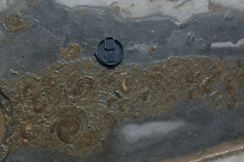
The site has been described as being rich in reptile remains and it is not uncommon to find bones at Lilstock on the foreshore and in the cliff. Complete skeletons are regularly found at the locality, although on this trip the finds were somewhat more fragmentary. Lilstock also yields ammonites, shells and fish remains. On the day, everybody was able to find a mixture of fossils, with the ammonite Psiloceras planorbis being the most common. A single Ichthyosaur vertebra was found in the lower part of the succession and many indeterminate fossil bones were also found. The site yielded many coprolites with examples containing fish scales, parts of bones and fish teeth.
 In the afternoon the group moved to the eastern section of the coast and looked at the exposures of the Westbury Formation, where many different fossils were found in the Triassic beds exposed along the foreshore.