Thames Barrier
London, England
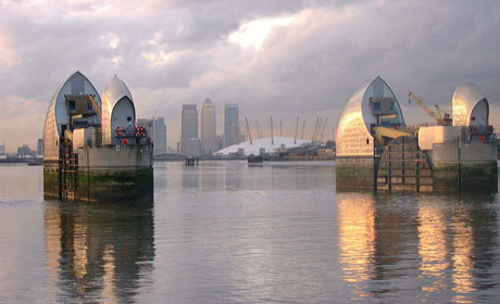
Opened in 1984, the Thames Barrier is an impressive civil engineering achievement. Extending across the river at Woolwich Reach, the barrier is part of London‘s defences against the risk of flooding and comprises a series of giant movable gates which can be closed when an exceptional high tide is expected.
 The level of high tides in the Thames Estuary has been steadily rising and since the severe east coast flooding of 1953 it has been recognised that there was a need to improve London’s flood defences.
The increasing flood risk is due to rising sea levels as a result of global warming combined with the fact that South-East England is slowly sinking leading to an increase in the tidal range. Tide records indicate an alarming 8 millimetre per year rise in the level of the Thames Estuary.
Design and construction of the Thames Barrier has been well documented. Because the design of the piers, sills, gates and machinery could not tolerate any movement in the foundations the ground investigations had to be extremely thorough. Seventy three boreholes were sunk which revealed that the northern half of the site is underlain by Thanet Sand and the southern half by Upper Chalk. Fortunately the chalk bedrock was below that affected by periglacial activity (i.e. permafrost conditions) during the Ice Age which has turned the surface of the Chalk elsewhere into an unstable rubble by frost shattering.
However, some difficulties were encountered such as minor faults with lateral and vertical displacements of up to 50 meters and 5 metres respectively. The Thames Barrier, in fact, sits astride the Greenwich Fault, a major fracture in the deep bedrock of the region.
The Greenwich Fault passes across the northern limb of the Greenwich Anticline and continues north-east into Essex where it is known as the Wickham Bishops Fault. This fault is thought to have been responsible for the Essex Earthquake of 1884 and so seismic studies were carried out as part of the investigations which concluded that there was insignificant risk of further tremors in the area arising from this fault.
The Thames barrier has a visitor centre and a terrace café on the south bank of the river.
Text courtesy of The Essex Field Club using the sources to the right.
Watch the British Geological Survey's video on the Geology under London:

Related Links:
Visiting information
References
Ellison, R.A. 2004 Geology of London. Special Memoir for 1:50,000 Geological sheets 256 (North London), 257 (Romford), 270 (South London) & 271 (Dartford). British Geological Survey. Page 80.
Fookes, P. 2006. Thames Barrier 21st anniversary. Geology Today. Vol. 22 No.2 (March-April 2006). Pages 48-50.
Gilbert, S. & Horner R. 1984. The Thames Barrier. Thomas Telford Limited. Pages 82-85
Images (top to bottom):
- Thames Barrier at low tide © Ken Brown (Source Geograph.org.uk) Creative Commons Attribution-ShareAlike 2.0 license.
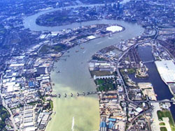
- Thames Barrier from the air
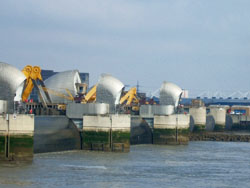
- The closed barrier © David Smith (Source Geograph.org.uk) Creative Commons Attribution-ShareAlike 2.0 license.

October 13 - 21
Theme: 'Earth Science in our lives'