County Clare, Ireland
 Spectacular Scenery
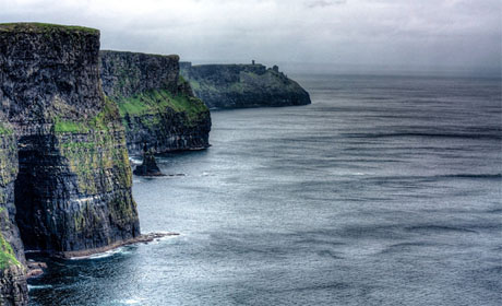
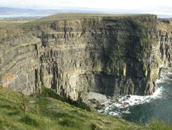
These vertical sea cliffs in Upper Carboniferous shales and flagstones are of iconic status as a tourist attraction. The site is of International importance and has been recommended for geological Natural Heritage Area designation under the Geological Survey of Ireland’s IGH9 Upper Carboniferous and Permian and the IGH3 Carboniferous - Pliocene Palaeontology themes. The site is listed as a County Geological Site in the Clare County Development Plan.
 Compared to the nearby rocks of the Burren, the shales, siltstones and sandstones that make up the Cliffs of Moher and the area south west of Lisdoonvarna and Kilfenora were formed much more rapidly from sand and silt being washed into the sea by a major river system which has long since disappeared.
Doolin to Hags Head.
The cliffs at Doolin that extend towards the southwest expose the uppermost part of the Clare Shale Formation. These rocks have yielded a rare neopteran pterygote insect, which possessed wings that could be folded over the insect’s body. These wings were a major evolutionary advancement allowing the insect to access confined spaces in plants and rocks for food and shelter. This is the earliest such example of this type of insect in the British Isles. The section has also yielded goniatitid ammonoids, important in dating their host rocks.
 The coastal section has a remarkable development of sand volcanoes in Carboniferous beds over-lying slumped shales and sandstones.
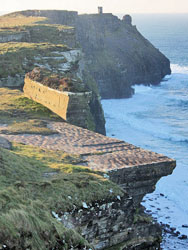
The ‘Fisherstreet Slide’ is a distinctive sheet, 30 metres thick, extending over some kilometres of the section. The entire sheet moved as a sedimentary slide, and now contains a wealth of soft sediment deformation features. It is part of the Gull Island Formation from Doolin southwards until the Central Clare Group comprises the bulk of the cliffs from O’Brien’s Tower southward.
The cliffs also illustrate cyclothems I and II (Tullig Cyclothem and Kilkee Cyclothem) of the five in the Central Clare Group. These cyclothems are repeated sequences of mudstone, siltstone and sandstone, formed by normal processes in the deltaic environment that created these rocks. They are normally separated by thin marine bands with distinctive goniatite fossils, allowing correlation of rocks and events across a wide area. They comprise a basin fill sequence with the greater depth and development of the basin in south west and central Clare.
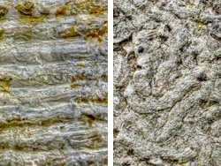
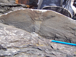
Accessible ledges of the sandstones also contain a wealth of trace fossils, apart from the very well known Liscannor Flags, which has the burrow Olivellites in abundance.
Continental Collision and Ice Ages
Shortly after these rocks were formed the entire continent collided with what is now Europe. This caused the rocks, which were originally horizontal, to become gently folded as we can see at Mullaghmore; in fact all the rocks of the Burren are tilted slightly to the south.
 The enormous forces that caused the folding are also responsible for the many cracks and fissures the run through the limestone now.
Much later, only about 1.8 million years ago the ice age started. Huge masses of ice over 200m thick came from the north and north east and scoured the surface ripping up soil and rock and carving valleys and then depositing the rocks and clay as the ice melted. We can see these rocks scattered across the Burren as glacial erratics today.
Along the coast there are many rocky beaches where it is possible to find rocks which are not originally from the Burren, these granites, red sandstones and others were carried by the ice from Connemara and east Clare and have been eroded by the sea from the glacial deposits left by the ice.
Text courtesy of Sarah Gatley (Geological Society of Ireland and Irish Geoparks Forum), and the Burren and Cliffs of Moher Geopark