Edmund Booth, who spoke yesterday at the British Science Association Festival in Aston University, is an independent structural engineer with many years’ experience in earthquake engineering.
He visited Haiti earlier this year to test out a new technique for post-disaster planning called “Pictometry” – a technique that allows large areas to be surveyed quickly. The system was developed in the US by a company called Pictometry International.
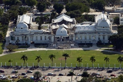
Aerial images are taken from low-flying aeroplanes, at an angle of forty degrees to the ground. Pictometry’s Electronic Field Study software allows a variety of measurements to be taken directly from the image - including height, distance and area, as well as elevation and bearing. Images can be overlaid with shapefiles and GIS information can be exported. In general, this approach results in much more visual detail than can be obtained with satellite photography, because it gives multiple perspectives with overlap, creating 12 to 20 images of each location. Speedy surveys for disaster relief, where such detailed oblique views are essential to detect the scale of damage in collapsed buildings, are one of Pictometry’s major applications, according to the company’s website.
Earthquake proofing
Nobody was very surprised that so large a proportion of Haiti’s buildings fell down. Earthquake-proofing is generally regarded as the preserve of rich countries like the USA and Japan. However this is no longer necessarily true, according to Booth. “Structural engineers have been confident for many years that they can design and build houses, offices, hospitals, even skyscrapers which are robust enough to protect their occupants from harm in devastating earthquakes” he said. But nowadays this was possible “at an additional cost, but one which adds only a few percent to the budget”.
“At slightly higher cost, some sophisticated engineering techniques have been developed to produce buildings that people not merely “walk out of” unscathed after a major shake, but which can even continue to function normally. Clearly, that is vitally important for a hospital that has to treat earthquake casualties, or for government or NGO offices from which a massive relief effort has to be planned and co-ordinated.”
Haiti’s earthquake produced a few examples of such buildings. The US Embassy, completed only last year and designed to the latest seismic engineering standards, was almost undamaged by the earthquake. Tragically, the vast majority of buildings in the epicentral area fared much worse. As much as 15% of the total population of Haiti were made homeless by the earthquake, with a much higher proportion in the capital.
“Compounding this was the fact that most official buildings fared no better; the loss of functioning office space and the knocking out of many key local and expatriate staff through death or injury dealt a major blow to Haiti’s ability to respond to the disaster” he told the Science Festival. “These difficulties were all fundamentally caused by the failure of structures; but subsequent investigations show that they failed because of well known, well established defects in design and construction.”
The wide scale destruction and pressing need for a massive relief effort led the Haiti Government and international community to embark on a Post-Disaster Needs Assessment (PDNA) process, and one of the first tasks was to establish the scale and nature of the damage. However, this too was fraught with difficulties; the same problems that prevented aid from reaching the country made damage assessment from the ground equally hard.
To counter these difficulties, a unique exercise was initiated within hours of the earthquake. Aerial and satellite photographs, similar to
Google Earth but of a quality usually only available commercially at considerable cost, were released without charge by a number of companies, including Google and Pictometry, and distributed via the Internet to an international network of 700 volunteer engineers and scientists called GEO-CAN.
Each volunteer was assigned photos covering a few square kilometres of the epicentral area, and reported back the extent of damage on their area. In this way, a very rapid and comprehensive picture of the damage was established.
“The technique has been in use for a few years now” said Booth, “but the use of a large volunteer army to carry out the assessments was unique, and the quality and sophistication of the images has also improved greatly since satellite images were first used for damage assessment in the early years of this millennium. UK company Cambridge Architectural Research Ltd was another key player in the Haitian exercise, which undoubtedly made a significant contribution to assessing needs, and therefore to directing and planning relief efforts.”
Further information