Product has been added to the basket
Articles

Bruce Yardley appointed Chief Geologist

Bruce Yardley (Leeds University) has been appointed Chief Geologist by The Radioactive Waste Management Directorate (RWMD) of the Nuclear Decommissioning Authority (NDA).

Chartership news

Chartership Officer Bill Gaskarth reports on a projected new logo for use by CGeols, advice on applications and company training schemes

Climate Change Statement Addendum

The Society has published an addendum to 'Climate Change: Evidence from the Geological Record' (November 2010) taking account of new research

Cracking up in Lincolnshire

Oliver Pritchard, Stephen Hallett, and Timothy Farewell consider the role of soil science in maintaining the British 'evolved road'

Critical metals

Kathryn Goodenough* on a Society-sponsored hunt for the rare metals that underpin new technologies

Déja vu all over again

As Nina Morgan Discovers, the debate over HS2 is nothing new...

Done proud

Ted Nield hails the new refurbished Council Room as evidence that the Society is growing up

Earth Science Week 2014

Fellows - renew, vote for Council, and volunteer for Earth Science Week 2014!  Also - who is honoured in the Society's Awards and Medals 2014.

Fookes celebrated

Peter Fookes (Imperial College, London) celebrated at Society event in honour of Engineering Group Working Parties and their reports

Geology - poor relation?

When are University Earth Science departments going to shed their outmoded obsession with maths, physics and chemistry?

Nancy Tupholme

Nancy Tupholme, Librarian of the Society and the Royal Society, has died, reports Wendy Cawthorne.

Power, splendour and high camp

Ted Nield reviews the refurbishment of the Council Room, Burlington House

The Sir Archibald Geikie Archive at Haslemere Educational Museum

You can help the Haslemere Educational Museum to identify subjects in Sir Archibald Geikie's amazing field notebook sketches, writes John Betterton.

Top bananas

Who are the top 100 UK practising scientists?  The Science Council knows...

East Anglia's buried channels


Stephanie Bricker, Jonathan Lee, Vanessa Banks, Anthony Morigi and Marieta Garcia-Bajo* uncover the past in 3D

Geoscientist 22.04 May 2012


As Quaternary glaciations gripped eastern England blanketing it in swathes of ice, torrents of subglacial Map of the study area showing the pre-glacial River Bytham and River Thames, Anglian glaciation limit, tunnel valleys as defined by Woodland (1970) and the underlying 1:625,000 bedrock geology. Geology data, BGS ©NERC 2011.meltwater carved a network of channels through the ice sheets and buried landscape, partially superimposing themselves on pre-glacial river networks. Reaching depths of up to 100m, these buried channels produced a significant scar in our subterranean environment - one that often has no surface expression but which is of considerable consequence to modern hydrogeological processes and our understanding of the dynamics of ancient ice sheets. Where these channels were once enveloped by a great thickness of ice they are now in-filled and buried beneath more recent superficial deposits.

We cannot claim to be pioneers in uncovering these glacial features since several geologists identified the existence of palaeovalleys in East Anglia in the late 19th Century. It wasn’t until 1970 though that Austin Woodland CBE PhD (1914 – 1990), while working at the Institute Geological Sciences (now British Geological Survey) collated information from water supply borehole records to map the distribution of the buried valleys in sufficient regional detail1.

Image:  Map of the study area showing the pre-glacial River Bytham and River Thames, Anglian glaciation limit, tunnel valleys as defined by Woodland (1970) and the underlying 1:625,000 bedrock geology. Geology data, BGS ©NERC 2011.

Austin Woodland Austin Woodland’s PhD (1939) was a study of manganese-bearing rocks in Meirionnydd, Wales - so why his interest in buried valleys? Woodland was born in Glamorgan, eldest son of a colliery carpenter. After graduating from the University of Wales, Aberystwyth he joined the Geological Survey. Not unusually in the Survey, his first assignment exposed him to completely different geology - a detailed assessment of water resources in Eastern England. This involved extending the known limits of the Crag - and deducing the presence of subglacial streams.

Woodland (picture) proved to be an effective science manager and went on to become the Director of the British Geological Survey in 1970. Now, with computer technology we are able to revisit his work and define the extent of these buried channels in 3D. In doing so, we are able to establish the inter-connections between the pre-glacial setting of central and eastern England, and the modern day hydrological regime.

Block model showing the sub-glacial and englacial tunnel valley formation along with the geological tunnel valley legacy upon deglaciation.

COLDER CLIMES

Image:  Figure 2: Block model showing the sub-glacial and englacial tunnel valley formation along with the geological tunnel valley legacy upon deglaciation.

Prior to the major glaciations of the Quaternary, the drainage patterns of central and eastern England were very different from the river systems we know today. It is only in the reconstruction of these older pre-glacial river systems that we understand the present day distribution of superficial deposits, some of which lie far from our modern river valleys2.

In summary, the region was drained by the easterly flowing Bytham River which joined the North Sea near Lowestoft while the River Thames discharged to the North Sea near Ipswich. The most extensive glaciation to affect the region occurred during the Anglian, some 450,000 years ago, and was responsible for destroying the Bytham River and diverting the lower reaches of the River Thames to their present course (FIGURE 1).

It is therefore possible to distinguish two types of buried valley in East Anglia: (i) relict pre-glacial river valleys – including the ancestral rivers Bytham and Thames and their tributaries, and (ii) subglacial ‘tunnel valleys’ that formed beneath the ice sheets. The latter are common features within glacial environments and research into the locations, orientation and geometry of the valleys is traditionally used to understand the subglacial hydraulic regime and assist in the reconstruction of former ice sheet development.

There has been considerable debate regarding both the genesis of the valley features and the name they are ascribed. The terms ‘tunneldale’ in Denmark and similarly ‘rinnentaler’ in Germany were coined to describe subglacial meltwater-eroded valleys not buried by ice. This was translated to ‘tunnel valley’ by Woodland, to describe all buried valley features in the UK. Accordingly, many use the term ‘tunnel valley’ for both open-channel and buried valleys of inferred subglacial origin.

Referring to buried tunnel features as valleys is not entirely appropriate either, as they do not always exhibit a falling head along their profile. Since subglacial drainage channels are formed beneath ice sheets, meltwater frequently flows under hydrostatic pressure and as such the water may flow ‘uphill’ along the hydraulic gradient. With subglacial drainage channels occupying space within both the overlying ice sheet (‘englacial’) and the underlying substrate, and emanating from the ice margins in fans, the subsurface expression of the subglacial channel upon deglaciation is rather inconspicuous and not akin to modern river valley form or pre-glacial river valleys. (FIGURE 2)


2D delineation of mapped buried valley along the modern day River Stour. Contains Ordnance Survey data © Crown Copyright and database rights 2011. The trace of tunnel valley deposits remaining within the geological succession may be patchy, undulating or anastomosing, depending upon the extent to which the channel carved its path through the ground as opposed to the overlying ice sheet. The absence of a buried valley deposit within a borehole record does not necessarily mean that the buried valley did exist at that point. For instance, its base may have become elevated into an englacial position, or its form may have been subsequently eroded from the geological record. Piecing together the buried valley environment is therefore a complex task.

Image: Figure 3 - 2D delineation of mapped buried valley along the modern day River Stour. Contains Ordnance Survey data © Crown Copyright and database rights 2011.

BURIED VALLEYS

Working on his own and with limited technology, Woodland’s efforts in mapping the buried valleys of East Anglia are commendable. Using only the geological borehole logs from the water supply well records, Woodland was able to mark the approximate, albeit perhaps over-interpreted, course of 16 buried valley systems, and attempted where possible to mark the level of the underlying bedrock. With access to nearly 30,000 borehole records held by BGS (and now available online at www.bgs.ac.uk/data/boreholescans/home.html), including over 8000 mineral assessment boreholes, we are now in a far better position to delineate the 3D form of the valley features and consider their inter-relationship with the underlying bedrock. We also have access to a superficial drift thickness model, bedrock surface model and the 1:50,000 digital superficial map (DIGMapGB50) to direct us to the most appropriate areas of search.

These datasets were used in combination to record the presence and thickness of buried valley deposits. At the same time other key geological descriptors were recorded, including the type of buried valley infill material, type of underlying geology and its engineering properties, for example evidence suggests that weathered or ‘putty’ chalk is often present beneath buried valleys. The contours of the buried valleys (relative to OD) were produced with Geographical Information System (GIS) software using the derived buried valley thicknesses and a digital terrain model provided by the Centre for Ecology and Hydrology (Morris and Flavin, 1990) to create the 3D form of the buried valleys.


3D visualisation of sections of the Bytham buried valley network. Contains Ordnance Survey data © Crown Copyright and database rights 2011. Contains Centre for Ecology & Hydrology data © NERC 2011. We identify several major buried valleys within our area of study in East Anglia (Figure 3). In general, we see very good agreement with Woodland’s work, with buried valley deposits identified along all of the major channels he identified. However, we suggest that the channel deposits are less continuous than he implied. There are intervals along the valley where channel deposits appear to be absent from the geological record and may represent sections where the channel narrowed or became englacial.

The observed buried valleys appear to take two forms. First, there are narrower valleys associated with modern day rivers and streams (e.g. Stour, Stort and Cam), plus isolated valleys that are unrelated to modern drainage. The narrower channels are the classic sub-glacial ‘tunnel valleys’. Typically they are just 0.5 – 1km wide and heavily incised, reaching depths of up to 100m. Viewed in plan they tend to be fairly linear in form, as seen in the valleys of the rivers Cam and Stour. However, there is also a suggestion that drainage within the Stour may be superimposed upon a fault system within the bedrock.

Image: Figure 5 - 3D visualisation of sections of the Bytham buried valley network. Contains Ordnance Survey data © Crown Copyright and database rights 2011. Contains Centre for Ecology & Hydrology data © NERC 2011.

Gravel workings near Swinford, showing gravelly boulder clay on flint-rich glacial gravels, possibly en-glacially deposited. P210030 BGS© NERC The second type of buried valley is much wider and more continuous, and includes those found within the Hitchin-Stevenage Gap and along the course of the buried Bytham valley in central East Anglia. These larger channels are over 2.5km wide locally, and tend to have an undulating base punctuated with scour hollows where the thickness of the valley fill varies from less than 15m to over 100m. We interpret these channels and sections of their infill as pre-glacial river systems that drained central and eastern England prior to the Anglian glaciation.

Image: Gravel workings near Swinford, showing gravelly boulder clay on flint-rich glacial gravels, possibly en-glacially deposited. P210030 BGS© NERC

Certain buried valleys appear to exhibit a polyphase history. The Bytham River valley, for example, contains sand and gravel deposits that include a number of discrete but mappable terrace aggradations. However, parts of the valley appear to have been reactivated, with a later, narrow and deeper subglacial channel scoured along part of the southern valley flank between Thetford and Diss. An interesting feature of the Bytham buried valley (Figure 5) is that greater scouring appears to occur where the buried valley crosses onto the Upper Chalk (stratigraphers please note – we are employing these terms in their colloquial sense). The scouring is linear in form, occurring at right angles to the main Bytham channel, coincident with the modern day Black Bourn – a tributary of the Little Ouse near Thetford.


Cross-bedded glacial outwash sands, photographed at a gravel pit near Costessey, Norfolk. P210925 BGS© NERC While the Black Bourn is a modest river, with flow some 100 times smaller than the Thames at London, its subglacial counterpart had enough energy to scour hollows 80m deep. Though no faulting is indicated on the geological map, it is highly likely, given the linear form of the scouring which follows the same orientation as several other river channels locally, that the subglacial valley follows the line of a fault or dominant fracture set within the underlying chalk. A zone of high transmissivity within the chalk beneath the valley offers further evidence for this.

Image: Cross-bedded glacial outwash sands, photographed at a gravel pit near Costessey, Norfolk. P210925 BGS© NERC

As the Anglian ice sheet advanced across the Midlands and East Anglia from the west, it eroded sections of the Jurassic clays and limestones, which were subsequently re-deposited as tills across the east of the region (Lowestoft Till), and created a topographic low within which the Fens lie. Contemporaneously, the chalk escarpment, which trends in a SW-NE direction across western East Anglia, was also eroded causing it to migrate in a south-easterly direction.

Curiously, some of the buried valleys terminate and appear to be absent across the Lower Chalk that occupies sections of the scarp slope. The exception to this is the Hitchin buried valley, which cuts a deep channel through the chalk escarpment at the Hitchin Gap. By plotting a geological section along the subglacial channel within the Cam valley we examine whether it is a lithological control exerted by the Lower Chalk, or the influence of the subglacial topography that determines the formation or otherwise of buried valleys in this setting. In fact, it appears that the Melbourn Rock (a hard bed of cemented chalk at the base of the Middle Chalk) is acting as a base level for buried valley formation and may explain the absence of buried valley deposits over the Lower Chalk.


Glacial sands and gravels within Frettingham Lime Co. Pits. Norfolk. P210935 BGS© NERC

IMPLICATIONS

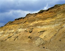
Image: Glacial sands and gravels within Frettingham Lime Co. Pits. Norfolk. P210935 BGS© NERC

Mapping the 3D form of buried valleys is not just of benefit to Quaternary geology - there is value for engineers and the water and aggregate industries. Our interest is the interaction of buried valleys with hydrological systems. Knowing the spatial distribution and form of buried valleys allows us to develop an idea of how these pre-glacial and subglacial channel systems have shaped modern river networks and aquifer characteristics.

For example, we observe that modern day rivers often follow the same course as the buried channels. Buried-valley infills may themselves form viable aquifer units. Though spatially restricted, their depth makes them an inviting prospect for groundwater resources, and countries such as Denmark and USA are already exploiting them.

Permeability of East Anglian buried valley infill deposits was calculated using grain-size distribution. Although there is incomplete coverage across the network, there are higher permeability deposits, associated with a basal sand and gravel unit within the Bytham River and River Stour valley deposits, occurring below a shallower, less permeable fill. The distribution of valley infill deposits is not unexpected for a valley of polyphase origin, with successive phases of pre-glacial, glacial and post-glacial erosion and deposition having given rise to a complex sequence of both layered and unsorted deposits of varying permeability.

In East Anglia, the superficial deposits in the north and west of the region are largely underlain by the Chalk Group - a principal aquifer supporting over 40% of public water supply locally. Consequently there is a drive to understand the hydrological characteristics of the chalk, including its resource potential and its vulnerability to contamination.

In mapping the buried valleys we see a potential control being exerted by the channels on the underlying chalk. Comparatively high transmissivity values appear to be associated with several buried valleys, the highest of which being coincident with the Bytham River valley and the modern day Black Bourn. With raised transmissivity provided initially by bedrock structure, chalk permeability is likely to have been enhanced by subglacial hydrostatic pressure and dissolution beneath the ancient river deposits. A zone of high transmissivity is also observed along the River Stour buried valley, which is also thought to be part of the pre-glacial Bytham drainage network.

Where hydrostatic pressures were sufficient, subglacial meltwater could have eroded significant sections of the pre-glacially weathered chalk, before the tunnel valleys were formed. The engineering properties of chalk beneath buried valleys tends to support this idea – soft, more weathered chalk occurring under the pre-glacial Bytham River, River Stour and the pre-diversionary Thames; harder chalk occurring under the tunnel valleys of sub-glacial origin.

In line with this argument we see the harder chalk hosting the more deeply eroded sections of the buried valleys where thicker buried valley deposits are recorded. The relationship between the buried valley and the underlying chalk and its influence on aquifer characteristics is not simple and would appear to depend not only on the chalk unit within which valley is eroded but also on the origin of the valley. Coupled with this, the buried valleys are highly heterogeneous both in form and nature of infill. It is the juxtaposition of higher permeability fill within buried valleys (particularly those of the Stour and ancient Bytham river) with zones of high transmissivity in the underlying chalk that arouses interest. While these zones provide a hotspot for preferential groundwater recharge and aquifer productivity, they also provide potentially rapid pathways for contaminants, leaving the chalk aquifer extremely vulnerable to polluting activities.

Delineating buried valleys in 3D does not by itself answer all questions with respect to the management of groundwater systems. It does however provide a focus for future research and is of benefit to other disciplines. Whether the interest is engineering, aggregates or offshore exploration, there is much to be gained from the 3D delineation of these buried valley features.

References

  1. Woodland, A W 1970: The buried tunnel-valleys of East Anglia Proceedings of the Yorkshire Geological Society 37: 521-578
  2. Rose, J , Moorlock, B S P and Hamblin, R J O 2001: Pre-Anglian fluvial and coastal deposits in Eastern England: lithostratigraphy and palaeoenvironments Quaternary International 79: 5-22
  3. Brenchley, P J and Rawson, P F (Eds) 2006: The Geology of England and Wales The Geological Society, London
  4. Morris, D G and Flavin, R W 1990: A digital terrain model for hydrology Proceedings of the 4th International Symposium on Spatial Data Handling: 1990, Zurich, Switzerland Publisher: [Zurich, Switzerland]: Dept of Geography, University of Zurich; ISBN: 3906254992; 250-262