Product has been added to the basket

The Christchurch earthquake: what happened?

A statue of William Rolleston (Superintendent of Canterbury, 1868–75) shaken from its pedestal. © D. Wilson

Engineering geologist David Boon (British Geological Survey) has been to see the effects of the February earthquake in new Zealand, and unpicks events leading up to and following the catastrophe.


Geoscientist Online Special 11 May 2011


On the 22 February 2011, New Zealand geologists probably got quite a surprise when the GeoNet, New Zealand’s Natural Hazards monitoring Platform, (www.geonet.org.nz) recorded a M6.3 earthquake just 10km from the country's second largest city, Christchurch. The epicentre was located as 43.60o S, 172.71o E, placing it in the Port Hills area, 5km west of Lyttleton Harbour, and the focus was very shallow at a depth of 5km. The 500m high, Port Hills are the resistant remnants of an extinct five million year-old volcano, which create a topographic high surrounded by the flat, low-lying and vast alluvial Canterbury Planes. The ‘quake was theoretically an aftershock from the M7.1 Darfield earthquake that had shaken the city on 4 September 2010; but its effects were far more devastating, causing major damage and loss of life in Christchurch and Lyttleton.

The ‘warm up’ event


Five months before Darfield earthquake had shaken the city at 4.35am on a Saturday morning, when most people were in bed. GeoNet located the focus at a depth of 10km, 40km from the city centre. The earthquake caused moderate building damage and liquefaction and, miraculously, there were no lives lost. Most New Zealanders were left feeling quietly confident that their earthquake building code had protected them. But some were less convinced, including a group of earthquake engineers at the University of Canterbury who warned that the shaking experienced during the 2010 earthquake had not been strong enough to fully test many of the city's pre-80s non-retrofitted buildings. Christchurch City Mayor, Bob Parker, now refers to the 2010 Darfield earthquake as just the ‘warm up’ event.

The fatal aftershock


After several large aftershocks including a M6 on Boxing Day, and a ‘textbook’ aftershock sequence, the probability of another large (>M6) aftershock in 2011 was looking very unlikely. But the city’s biggest test was yet to come; and the effects of the 22 February M6.3 aftershock were far more devastating than the main M7.1 Darfield Earthquake.


Fissures in the ground through which small mud 'volcanoes' had developed. © D. Wilson

The aftermath


The latest official figures (May 2011) reveal that there were 181 confirmed fatalities - 0.05% of the city’s population - and over 7000 injuries as a result of the February 'quake.  A month after the international media teams had left the scene, the country was still in a National State of Emergency, giving the authorities the power to 'lock down' New Zealand’s second largest city.

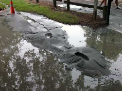
I visited the city three weeks after the 'quake to study the effects as part of the UK Earthquake Engineering Field Investigation Team (EEFIT). I joined one of the damage assessment teams, composed largely of volunteer engineers working tirelessly to ascertain the full extent of the damage. When I arrived, the entire city centre was encircled by fences manned by military patrols (for public safety and security). The streets were deserted and eerily quiet. The amount of damage is visually very obvious, with intensities reaching 9 on the Modified Mercalli intensity scale: un-reinforced masonry buildings crumbled under the strong shaking and many of the city’s historic buildings, including the tower of its famous cathedral, are now sorry piles of rubble. Extensive liquefaction of alluvial sediments has left a layer of fine sand on the streets, burying cars up to their doors. Post 1980s buildings were damaged, their columns shot through with X-shaped shear cracks, while several tower blocks have acquired a slightly uncomfortable lean. The streets are literally divided, having been torn apart by lateral spreading even on flat ground, but particularly along sloping ground on the banks of the Avon River.

Why so strong?


Several geological factors combined to make the M6.3 Christchurch Earthquake so much more destructive than the M7.1 Darfield Earthquake. Obvious reasons are that the epicentre was much closer to the city centre, the focus was also much shallower and the 'quake struck at 12:51pm when people were up and about. Even so, for a M6.3 earthquake the experienced ground-shaking in the city's Central Business District (CBD) was unusually strong, with vertical ground accelerations well in excess of 1g (1.42g) measured by GeoNet’s strong motion network – that is equivalent to the force required to lift 180 cups of tea! So what else was going on?

Hidden faults


As the damage inspection team entered an old building to make an internal inspection, our team leader, a Christchurch-born structural engineer, reminded me that “Christchurch is not meant to get big earthquakes, so this has come as a real shock to all of us”. In fact, in June 1869, a shallow earthquake of up to M5.8 was recorded under Christchurch, which caused damage to chimneys and masonry, and another possible M5.8 earthquake in 1870 occurred under nearby Lake Ellesmere. However, the fault segment that ruptured on 22 February 2011 was previously unknown to geologists. Russ van Dissen, geologist with the New Zealand Institute of Geological and Nuclear Sciences (IGNS), explained that the fault produced no surface rupture because it terminates 1km below the ground surface (a so-called ‘blind fault’). The national seismometer network deployed by GeoNet reported that it is an unusually steep reverse fault, orientated east-west with a southerly dip of 65 degrees. John Berrill, a Canterbury earthquake engineer who invented and installed the instruments that recorded the 'quake, suggested that the rupture started at 5km depth and then 'unzipped' upwards, generating multiple seismic waves aimed directly at the city.

‘Trampoline Effect’


Another contributing factor may be a phenomenon that IGNS seismologists call the ‘trampoline effect’, whereby soft, near-surface layers separate from stiffer underlying layers because they accelerate downwards faster. This results in a collision of layers, which generates additional energy. This effect may have contributed to stronger shaking and fueled the prolonged liquefaction.

The felt intensity generally diminishes with increasing distance from the earthquake epicentre but is also influenced by local soil conditions and topography. Christchurch sits on the edge of the Canterbury Basin, which is filled by up to 1500m of Quaternary alluvial and glaciofluvial sands and gravels, supplied by massive braided rivers that drain the eastern side of the Southern Alps. The upper 30m of sediment includes Holocene river alluvium, swamp peat, sand dunes and estuarine flats deposited during post-glacial sea level rise and recent river flooding. The soft/loose sediments under the city may have amplified the earthquake motions and caused them to liquefy. The lateral spreading of river banks caused many rivers channels to close-up and river beds to heave, leaving the many already low-lying areas now even more susceptible to flooding.


Landslides


The exceptionally high vertical and horizontal ground accelerations triggered around 170 landslides, affecting an area of about 150km2. The landslides were mostly rock falls, debris falls, and debris slides. Rockfalls crushed houses, blocked roads and left some buildings clinging to the cliff edge. Boulders rolled down slopes, bounced across roads, and crashed into houses. Tension cracks run along abandoned 9000 year-old sea cliffs and quarry faces, providing a warning of possible further instability that could be triggered by an aftershock or rainstorm. Rockfall debris continues to collect in gullies creating a debris flow hazard.

Recovery and resilience


With the immediate emergency relief effort now drawing to a close the recovery stage has begun. It is clear from extensive damage to the CBD that reconstruction of the city centre could take decades. Latest estimates predict that the rebuild will cost around 18 billion NZ dollars (£9bn). The 'quake has dealt a major blow to the city’s economy. Many businesses are unable to trade and many are going out of business. Then there is the massive physiological impact, harder to measure but just as painful. So, rebuilding the lives and livelihoods of Canterbrians will be one of the country's greatest challenges yet. As I climbed out from under a pub table after another emotionally-draining aftershock, a typically friendly Kiwi stranger asked me if I “want in on the sweepstake to guess how big the aftershock was”? A minute later, someone runs in clutching a seismic report from the GeoNet website- it was a 5.1 - and although I had lost the bet, I was consoled by how aware the Kiwi’s are of their own geology, and sharply reminded of how it unmercifully touches our lives.

I sank the remains of my half-spilt pint only hoping that we can apply the lessons learnt here in time for the next, sadly inevitable, ‘big one’.


Further reading

  • Forsyth, P.J.; Barrell, D.J.A.; Jongens, R. (compilers) 2008: Geology of the Christchurch area. Institute of Geological & Nuclear Sciences 1:250 000 geological map 16. 1 sheet + 67 p. Lower Hutt, New Zealand. GNS Science.
  • Hancox et al. 2011 NZ Earthquake Catalogue 2008
Editor's note:  The June print issue of Geoscientist will contain another BGS geologist, Dave Wilson's account of what it was like to experience the February Christchurch Earthquake, first-hand.