Product has been added to the basket

The Proof in the Puddingstone

Proof in the Puddingstone

The Proof in the Puddingstone: messages from a warm planet


Bryan Lovell*, sitting in a Hertfordshire copse, looks back on a life in sandstones and oil, and at the significance for Homo sapiens of events 55 million years ago.

Geoscientist 18.5 May 2008


Part One – the Pudding

Read Part Two

Read Part Three

This cautionary tale is, like all stories, based on imagination. That imagination is in turn guided and constrained by some implacable messages to be read in rocks 55 million years old: messages of great significance to our grandchildren and to the state of the planet we shall pass on to them. I write for the widest possible field of readers of Geoscientist, in the hope that those experts hungry for specialist technical meat will find nourishment in the References.


Not far from the road that the Romans called Ermine Street and we more prosaically call the A10, one can walk north across a ploughed field with a left foot on 85 Ma chalk and a right foot on 55 Ma pebble beds. Evidence from elsewhere suggests persistence of the chalk sea in this area until around 65 Ma, then land with sea breezes – and eventually the A10. A perfect location for lines from Tennyson previously favoured by geologists: “There, where the long street roars, hath been The stillness of the central sea”.

Above the field stands a copse. The farmer has not sought to bring it under the plough, and there’s a good reason. The line separating chalk and pebble beds is now obscured by thicker soil and well established trees growing between pits and mounds with relief of a few metres. Scattered on the surface between the roots lies evidence of the pebble bed below - rounded flint pebbles. These are mixed with a few angular fragments in which the rounded pebbles are firmly cemented together. Any fracture-surfaces in these angular fragments cut indiscriminately across both the flint pebbles and the cement that binds them. This is the Hertfordshire Puddingstone.

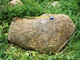
Hertfordshire Puddingstone artifacts discovered by Jane Tubb near 1. Hertfordshire Puddingstone artifacts discovered by Jane Tubb near Puckeridge, Herts. The main fragment is a failed attempt by a disappointed Roman to make a beehive quern. Over the years the farmer has been pleased to pass to an interested local geologist the larger fragments of puddingstone turned up by the plough on that path down the slope from the copse: Jane Tubb now has quite a collection (Figure 1). When the farmer’s plough meets a big lump of puddingstone, his plough breaks - but puddingstone does not. Our remote ancestors, shaping it for use as querns for milling grain, dug large concretions of puddingstone (Figure 2) out of the largely uncemented Paleogene pebble bed in which they occur, broke them up and shaped them in the copse - carrying or rolling the products down the hill to Ermine Street (Lovell & Tubb, 2006).

Looking down that slope from the copse to the ancient route below provokes some comparisons on technology. Grinding corn with puddingstone querns was more important to the survival in that area of our Stone Age and Roman ancestors than oil is to us today. You have to eat: you don't really have to consume hydrocarbons by driving up the A10 and then flying from Stansted to Malaga – although that could be fun in the company of at least some Fellows of the Geological Society.

Figure 3, a sketch I made in 1977, shows how land and sea in the area of Britain and Ireland were distributed some 80 million years ago. Hertfordshire is indeed under Tennyson’s central sea. Only bits of Scotland, Wales and Ireland form land; it is impossible to recognise anything resembling present-day coastlines. That map could only be sketched with confidence once we had information from beyond those familiar present-day shores, once exploration for oil and gas beyond the coasts of Britain and Ireland really got under way in the Sixties. That exploration led to some now-legendary early successes and provoked geological liaison across tribal boundaries that persists to this day.

Concretion of Hertfordshire Puddingstone, one of an outstanding collection made by the Parkins family of High Cross, Hertfordshire, during construction of the A10 bypass that cut through their farmland. Dr David Jenkins, Chief Geologist with BP in Aberdeen, was flushed with the company’s recent successful discovery of the giant Forties oilfield when, in November 1972, he came to Edinburgh to give a talk on North Sea exploration. I was his young host, then striving to be recognised as a specialist in sandstones formed in deep water, carrying out research at Edinburgh University. I had recently returned from my doctoral research with Raymond Siever at Harvard University, in an atmosphere where no one seemed snooty about either money or knowledge. Collaboration between geologists in universities and industry seemed there to be a natural part of everyday life, in a fashion then emulated in Britain only by a few pioneers such as (ex-Shell) Harold Reading at Oxford University.

A tyro is characteristically proud of his specialist abilities – in my case, to distinguish between different types of sandstone. Fresh from camping in a small green tent amidst the turbidites of the Eocene Tyee Formation of the Oregon Coast Range, I was certainly not snooty about applying knowledge to practical matters. After all, the oil industry had paid for the tent. I was also more than happy to supplement a junior lecturer's salary. I listened keenly to the Chief Geologist and offered what I considered to be some quite nifty ideas over dinner with David and Evanthia Jenkins at Denzler's Swiss Restaurant.

Jenkins told me that there was an unresolved debate within BP concerning the deposition of the Forties reservoir sandstones: deep water or shallow water? “The depositional environment… is still under study…” (Thomas & others, 1974, p.400). Although he did not discuss it in the restaurant that evening, Jenkins already had a line of evidence indicating a relatively deepwater setting. I first became aware of this at a remarkable conference convened in Bloomsbury in November 1974. At this now famous meeting, immaculately suited oil company men mingled with dishevelled British academics. For the first time the companies were sharing previously secret information and ideas about the North Sea.

3. Palaeogeography of Britain and Ireland around 80 million years ago (right), with areas of exposure of Late Cretaceous rocks shown (left) for reference. This sketch was made in the mid-1970s.

Shell had suffered a near miss with Forties, hitting only the eastern edge of the field in their own exploration acreage; but it was their man John Parker who spoke about the regional setting of this huge discovery. The rapt audience much appreciated being shown a seismic cross- section (Figure 4) (Parker, 1975): these were early days for what soon became the massive subject of seismic stratigraphy. From my brief view of the evidence flickering over the Bloomsbury screen, I could not be sure of the exact tracing of the key lines as they appeared to slope downwards from the Paleogene shoreline towards Forties, but the indications were that the reservoir had been deposited in relatively deep water.

A couple of months later, in January 1975, David Jenkins was back in Edinburgh. He was keen to recruit our better students from the Grant Institute of Geology into his team at Aberdeen, and into BP at large. We met in my room at the university and talked about graduate recruitment and about BP’s continuing internal debate on Forties sandstones. Two days later I found myself in a storehouse of cores of rock near Dyce Airport, ripping the lids off wooden boxes containing sandstone cores recently cut from Forties Formation, my excitement heightening on being told that I was the first “outsider” to look at these specimens of one of the most perfect oil reservoirs ever discovered.

4. Regional seismic cross section of rocks below the bed of the North Sea, extending from the east coast of Scotland into the Central North Sea where Forties oilfield is located. This section was first shown by John Parker of Shell.

Indeed the sandstones are almost too perfect to reveal their origin. They are mostly quite homogeneous, and so porous that they crumble readily (Figure 5). For me then - and now - a key part of identifying deepwater sandstones is the study of their relationship with interbedded mudstones. Not until late in the day did I open a box containing cores from the uppermost part of the main reservoir: at last - alternating layers of sandstone and mudstone. I delivered my verdict: Forties Formation was deposited in relatively deep water - proximal turbidites, so there was more sand away to the southeast (I said). I detected a thin smile on the face of the Chief Geologist. It was almost as if David Jenkins already knew the answer.

Later that year, when the proceedings of the Bloomsbury conference appeared in print, I could see why Jenkins had smiled. "You must have known what the seismic showed in detail when you asked me to look at those cores" I complained, when next we met. That thin smile again: "I wanted to see if it was possible to reach the correct conclusion simply from the evidence within the cores." It was. Two separate approaches had given the same answer, which in turn reduced BP’s risks in planning production from Forties, and guided new exploration.

5. Core of Forties Formation reservoir taken from c.2755-2765m depth in well Forties Delta 52 on 17th May 1982, as part of a programme to assess the feasibility of enhanced oil recovery using surfactants.

That crucial final box of cores of Forties sandstone in Aberdeen changed the life of my young family. Encouraged by this happy experience of the usefulness of both knowledge and money, my wife Carol and I formed a consultancy group with my Edinburgh University colleagues Brian Price and Terry Scoffin. Then in 1981 I accepted an invitation from BP to join the oil industry full-time and moved south, into Hertfordshire Puddingstone territory. So it was that, fourteen fascinating years later, in May 1995, I was visiting BP's Aberdeen office, enjoying talks on their research being given by Dr Nicky White and his young team from Cambridge University.

They explained that Scotland had first been lifted up some hundreds of metres out of the chalk sea around 65 million years ago, as a result of the intrusion of an underplate of magma a few kilometers thick at the base of the crust (Brodie & White, 1995). According to the Cambridge team, the classical geological history recorded in the glorious scenery of the Paleogene volcanoes of the Hebrides was only part of the story. Most of the magma had been trapped deep beneath the surface, like a permanent jack beneath a car, holding Scotland above the waves.

"How fast did that magma come in beneath Scotland?" I asked Nicky.

"About the speed of a Cambridge cyclist - to quote Dan McKenzie" came the reply.

"Did those cyclists arrive in batches?" I asked. "That is an odd question" replied White. "Why?"

"Because if they didn’t arrive in batches, your explanation cannot be entirely correct” I ventured. “We know that the sand-rich submarine fans formed episodically, with muds deposited between them. So there must have been a series of upward movements of Scotland, not just one big heave."

End of Part One. Part two of Bryan Lovell’s three-part essay will appear next month.

Read Part Two

Read Part Three