Product has been added to the basket

Peach and Horne - the memoir at 100

John Horne (left) and Ben Peach outside the Inchnadamph Hotel. Courtesy, BGS

January 2007 Vol. 17,1

Rob Butler* dusts down his copy of the North-West Highlands Memoir to find that it still talks to 21st Century geoscientists a century later…

On a small hill overlooking Loch Assynt in NW Scotland is a famous yet simple stone memorial to a remarkable geological double act: Ben Peach and John Horne. Generations of students have driven past this site, on their way to another, often rain-cooled day of field training, perhaps regaled by their lecturers of the exploits of their forebears and the golden years of NW Highland geology, at the end of the 19th Century.

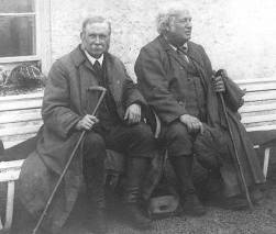
Much has been written over the years of these times and the exploits of the various protagonists. Visitors to the nearby Inchnadamph Hotel will have seen the famous photograph of the pair and perhaps posed on the bench outside the bar. This Bicentenary year also marks the centenary of Peach and Horne’s most remarkable publication, the Memoir The Geological Structure of the North-West Highlands of Scotland. Not only was it an instant classic, the 1907 Memoir remains a masterpiece of regional geoscience.

Famously Edward Suess, the Alpine tectonicist and synthesizer, remarked that Peach and Horne’s work had rendered the mountains transparent. The Memoir made key statements about structural geology, opening debates that remain unresolved and establishing NW Scotland as a key site in world geology. This importance continues today, with the recent designation of the region as a UNESCO Geo-Park. So what’s in the 1907 NW Highlands Memoir?

The geology of NW Scotland is highly varied, so the Memoir covers a lot of ground. The basic sedimentary units and their relationships are of course fully described. Perhaps I betray my background but it’s for the structural geology that I find the Memoir most perceptive. There are substantial discussions on the geology and evolution of the Lewisian complex, much of which we take for granted today. Peach, Horne and colleagues mapped out basic field relationships and used these to deduce a long and complex tectono-metamorphic history. The terms Scourian and Laxfordian were not coined until the 1950s by John Sutton and Janet Watson. But the Survey geologists had established that the meta-basic sheets within the Lewisian represented dykes and sills at different states of deformation and established the workflows for building tectono-metamorphic histories in basement rocks. What Sutton & Watson did was to make more detailed maps, but they followed essentially the same workflows.

Using the Survey maps for context, Peach and Horne’s colleague Jethro Justinian Harris Teall made detailed petrological studies to deduce links between deformation and metamorphism. This fired the starting pistol for research on reaction-related softening mechanisms in the continental lithosphere that continues today. By recognising that “the old lines of movement which existed before the Torridon Sandstone was laid down have in some places been used again in post-Torridonian time” (p. 251), the team were fully aware of the notions of structural inheritance, an issue again that is alive today.


The "zone of complication"

In his preface, Archibald Geikie predicted that the value of the Memoir lay in: “the full description and illustration which it contains of the remarkable tectonic structures, the discovery of which has made the north-west of Scotland a classic region for the study of some of the more stupendous kinds of movement by which the crust of the earth has been affected”. Geikie was referring to what we now know as the Moine Thrust Belt. Indeed it is for this that the Memoir is most famous, even though only about a fifth of it was concerned with thrust belt structures. John Horne’s introductory chapter to this part of the Memoir is a startling synthesis. For the first time it gave basic descriptions of imbricate slices, thrust sheets, the folds they contain and the thrusts that delimit them. There follows an account of the field localities that remains valuable today. The geometries were displayed on cross-sections, with text descriptions that outline the rationale behind the interpretations of structural geometry. Apart from structural geometry, the Memoir recounts the use of kinematic indicators to determining the direction of thrusting from the alignment of sheared worm burrows and related mineral fabrics. These insights build on the work on Peach and Horne’s contemporary Charles Lapworth in relating fault rocks, especially mylonites, to thrust evolution.

These interpretations were remarkable for the early 20th Century. But most of the thrust belt concepts were first published almost twenty years earlier by the team in their 1888 paper in the Geological Society’s Quarterly Journal. An expectant world had nearly a twenty year wait for the definitive article. Geikie commented that: “some geologists find literary labour more irksome and arduous than field-work, and would rather survey many square miles of complicated ground than write a few pages descriptive of them”. It is a sentiment since echoed, perhaps in more colourful language, by many a PhD supervisor.

It is a curiosity through much of science that apparently definitive statements on a subject commonly result in research activity moving elsewhere. So following publication of the 1907 Memoir there was scarcely any investigation of thrust system geometry in NW Scotland. In the middle of the century there were a few attempts to apply thrust-type interpretations in the complex world of ductile deformation in the Moine, notably by Kennedy and Watson, and much later by Geoff Tanner. Otherwise structural geologists focussed on detailed examination of deformation fabrics and indulged in labyrinthine numerations of fold phases.

Finally in 1980 things got going again, with Dave Elliott and Mike Johnson’s reinvestigation of structural evolution in the northern part of the belt. Elliott brought the balanced sections approach from the oil and gas industry exploring in the Rocky Mountain foothills. This represented new technology, with the interpretations of structural geometry shown on cross-sections tested geometrically through the ability to graphically restore the sections to pre-deformed state. But the application to NW Scotland relied heavily on the Survey’s century-old field observations. Jack Soper and Tony Barber took this further. Their geometric model for the deep structure of the thrust belt is arguably the first crustal-scale balanced section.

All the new ideas, together with the acquisition of deep seismic profiles (MOIST - BIRPS’ first profile was explicitly designed to image the Moine Thrust on a crustal scale) prompted a wholesale re-examination, by a team led by Mike Coward. This involved substantial new mapping of the region and, although the maps themselves were not published at the time, they are a key component of the new compilation of Moine Thrust Belt maps being published currently by BGS.

One of the key issues concerning those of us who have worked in the Moine and other thrust belts over the past twenty years has been the sequence and nature of tectonic contacts. It provides an illustration of how the Memoir retains topicality. The general challenge might be framed today as understanding the patterns of strain localization in continental crust. Deducing the relative activity of faults is a key part of this work. 21st century tectonicists might use sophisticated monitoring campaigns in tectonically-active regions to examine slip rates on faults, backed up with absolute dating using the multitude of geochronological tools at their disposal. 19th century field geologists used cross-cutting relationships displayed on maps and sections, and these still provide critical tests for modern data. It is not surprising, but none the less sobering, to find John Horne discussing the “Probable sequence of movements” in Chapter 32 of the Memoir. His general conclusion was that the structurally higher thrust planes moved last, slicing across earlier, more outlying structures. Consequently it was this style of structural relationship that appears on the cross-sections of the time.


Field slips

It is worth investigating where the notion came from. Carefully archived at Murchison House, BGS have retained Ben Peach’s notebooks and field slips. At an early stage in their investigations the Survey team sought an explanation for the repetition of stratigraphic units as encountered on transects across structural trend. In a world without thrusts such repetitions would classically be interpreted as due to folding. But Peach saw that this predicted a symmetrical alternation of rock units, not the asymmetrical pattern he found. So he proposed imbricate faulting. Field notes include a modern-looking sketch in which imbricate thrusts repeat stratigraphy, alongside the restored geometry. It’s almost the world’s first balanced and restored cross-section. The figure even illustrates how different erosion levels through the structure generate different outcrop patterns. No wonder his contemporaries held Ben Peach in such high regard.

Peach’s sketch from the 1880s is informative because it also shows the limitations, albeit viewed with 120 years of hindsight! For his restoration attempts to explain neither the relationships between the imbricate thrusts themselves, nor with any major thrusts that might contain them. And it is in these parts that the key lies in resolving the issues of fault sequencing. In the Memoir John Horne notes that imbricate thrusts are generally overstepped by whichever major thrust plane overlies them, arguing that this requires truncation. Thus higher thrust surfaces were believed to postdate the imbricates below. The duplex model applied by Elliott and Johnson in 1980 treated these relationships differently, arguing that the imbricate thrusts merge into the overlying thrust planes. This model, generally termed “piggy-back thrusting” is widely believed to be the more appropriate nowadays.

Horne’s Memoir chapter 32 indicates that there was no model of thrust sequences that worked universally in the thrust belt, hinting at debates between Peach on one side and Lapworth and Cadell on the other. A famous exception to the then-preferred overstep model is the Dundonnell structure, found just south of Ullapool. The Survey’s section shows higher thrusts, including the Moine, folded by what might now be called a detachment fold developed on the Sole Thrust. This part of the thrust belt was mapped by William Gunn somewhat later in the campaign than the classic Assynt and Eriboll sectors where the overstep model was erected. There must have been some interesting discussions convincing the more senior members of the team of the geometry. A century later Elliott and Johnson seized on the Dundonnell structure as their key representation of piggy-back thrusting, reinterpreting the fold at its core as a stack of imbricate thrusts. Given the subsequent fame of the Dundonnell structure, including being cited as an ideal demonstration of a specific duplex type, it is ironic that it lies in an area of perhaps the poorest exposure in the entire thrust belt.

The two models of thrust sequences make different predictions of how the stratigraphic units are distributed against thrust surfaces. In other words, different geological maps demand different structural interpretations. A common conceit is that field maps should be objective documents. Edward Bailey in his Tectonic Essays maintained that Peach and Horne “merely reproduced what they saw in Nature, and left it at that”, working in “an atmosphere of detachment”. Yet it is clear from Horne’s chapter 32 in the Memoir that thrust relationships had been a topic of discussion throughout the mapping campaign. And Peach’s hypothetical illustration of imbricate structures made clear predictions of stratigraphic relationships.

The mapping was by no means objective and free of hypothesis – of course it never is. No field geologist can ever hope to record everything. What is recorded depends on what hypothesis is being tested at the time. So it’s as well to have a hypothesis to test! Consequently it means that in areas of complex structure, new hypotheses making new interpretations generally require new mapping. Fortunately, attempts in recent years to generate standardised workflows and methods of field investigations, beyond the basics of recording simple data and observations are no longer fashionable as they stifle new ideas and fossilize perhaps erroneous hypotheses. Any objectivity they might provide is entirely illusionary.

Through the early 1980s Mike Coward, his students and colleagues set about remapping swathes of the Moine Thrust Belt. Like Ben Peach, Coward was a great one for developing ideas in the field, returning from regular forays in the thrust belt with new hypotheses and novel structural geometries. The mapping uncovered relationships between rock units that had gone unrecognised by Peach and Horne that were at least consistent with Elliott and Johnson’s notion of piggy-back thrusting, But there were entirely new geometries too, where higher thrusts were re-imbricated along with the rocks that underlay them. And Coward found sites where low angle thrusts truncated the imbricates below, as proposed by Peach and Horne. The reality is that there probably is no general sequence of thrusting. Indeed other thrust belts where there are stratigraphic constraints on timing show synchronous thrusting and that any strictly sequential models are illusionary.

Coward proposed that many low-angle, truncating structures such as proposed by Peach and Horne were actually extensional and found other such structures within the major thrust sheets. The debate still rumbles on as to the significance of truncating structures, so these debates are by no means settled. Indeed they probably cannot be resolved definitively in the Moine Thrust Belt where there is little direct evidence for the orientation of the rocks at the time of deformation nor synorogenic sediments. However the key point is that each new interpretation has been based on a new map the construction of which falsified the previous map interpretations.

Each interpretation has its own suite of relationships between the various geological boundaries, be they stratigraphic or structural (or igneous). The challenge facing each new interpreter is to create a topologically robust three dimensional model and then to show the outcrop pattern of this structure in the landscape. And even if Coward’s proposition of extension cannot be tested definitively using the 400 million year old structures of NW Scotland, the concept has been applied and tested successfully in other parts of the world. So the Moine Thrust Belt has continued to inspire structural research internationally, in the same way that Peach and Horne’s descriptions did.

The geometric and spatial distribution of geological materials remains a fundamental part of understanding geological processes, especially in tectonics. And these relationships, in three dimensions are important constraints on models for their formation. If we don’t understand the product, how can we understand the processes? So understanding structural geometry will remain a critical issue for solid earth science. The need to challenge geometries of previous interpretations suggests that field mapping will continue to be important too. However, in the 21st Century, with increasing use of 3D seismic and digital landscape data, there is a tendency to imagine that virtual world is the prime environment for developing structural geology understanding. Leading structural geologists in the oil industry, who routinely work 3D seismic, tend to disagree with this notion that field mapping is a thing of the past.

As Steve Matthews, Global Geoscience Adviser at BP told me: “Having worked in industry for over 23 years, I can think of no better training than field mapping projects for maturing ability in effective interpretation of 3D geological structure”. Field mapping, like seismic interpretation, rarely delivers a unique structural interpretation. Understanding the range of options is important, and attempting to map out structural geometry can quickly identify those hypotheses that are geometrically implausible.

The 1907 Memoir and the research it describes, portrayed in the spectacular series of 1” geological maps published by the Survey, is then a stunning achievement. It represents arguably the starting point for thrust belt research worldwide and established the international status of Peach and Horne. Above all it bears testimony to the importance of field mapping in areas of complex structure as the key tool for tectonic research. But field maps are highly interpretative. They illustrate hypotheses and marshal the spatial relationships between rock units that are explained by these hypotheses. This may sound horribly subjective, but at least the rocks remain to be visited. The experiments can be re-run to inspire new models and concepts. Within the NW Highlands Memoir it is the inspirational qualities of fieldwork that shines through the years.

  • Dr Rob Butler is Reader in Orogenic Geology in the Institute of Geophysics and Tectonics, The University of Leeds and continues to appreciate the cooling and rehydrating properties of Highlands fieldwork. Mike Johnson is thanked for comments on an early draft. E: [email protected]


Further reading and comments.

Belt or zone?

Many geologists use Moine Thrust "Belt" and Moine Thrust "Zone" interchangeably to mean all the thrust structures between the undeformed foreland and the sheets of Moine metasediments (what the Survey called the “zone of complication”). I prefer to use thrust "belt" for this – because that is what other thrust systems around the world are generally termed. Thrust "zone" to many conjures images of a single structure (e.g. shear zone). So in this regard it may be with using Moine Thrust Zone to refer to the Moine Thrust itself, perhaps with its associated mylonites.

There is no substitute for getting hold of the Memoir itself, the Assynt Special geological map (see below) or, for the northern part of the thrust belt, the preliminary report:

  • Peach, B.N., Horne, J., Gunn, W., Clough, C.T., Hinxman, L.W. & Teall, J.J.H. 1907, The Geological Structure of the NW Highlands of Scotland. Memoirs of the Geological Survey of Great Britain, p. 668.
  • Peach, B.N., Horne, J., Gunn, W., Clough, C.T., Hinxman, L.W., & Cadell, H.M. 1888. Report on the recent work of the Geological Survey in the north-west Highlands of Scotland, based on field notes and maps by Messrs. B.N. Peach, J. Horne, W. Gunn, C.T. Clough, L.W. Hinxman, L.W. and H.M. Cadell. Quarterly Journal of the Geological Society of London, 44, 378-441.
  • Otherwise the spectacular summary of Peach and Horne’s mapping is still available on the Assynt Special Sheet, published by BGS at 1” to 1 mile, complete with cross-sections (check out the BGS on-line bookshop). Historical perspectives are given by the entertaining account:
  • David Oldroyd’s 1990 “The Highlands Controversy: constructing geological knowledge through fieldwork in nineteenth-century Britain” (Chicago University Press, 1990), précised in Chapter 2 of Nigel Trewin’s “The Geology of Scotland” (4th edition, The Geological Society, 2002).
  • The first major re-interpretation of Moine Thrust Belt structure after the 1907 Memoir was:
  • Elliott, D. & Johnson, M.R.W. 1980. Structural evolution in the northern part of the Moine thrust belt, NW Scotland. Transactions of the Royal Society of Edinburgh, 71, 69-96.
  • The crustal-scale balanced sections appeared in:
  • Soper, N.J. & Barber, A.J. 1982. A model for the deep structure of the Moine thrust zone. J. Geol. Soc. 139, 127-138.
  • An account of Mike Coward’s researches, including a full reference list is in the following publication in his memory, which includes some modern papers on the Moine Thrust Belt too:
  • Ries, A.C., Butler, R.W.H. & Graham, R.H. (eds). 2007. Continental tectonics: a multidisciplinary approach. Special Publications of the Geological Society, No. 272
  • Many of the geological maps based on the 1880s work are still available for purchase from BGS (at 1:50,000 and 1:63,360). These include the classic Assynt Special Sheet – a real eye-opener!

A selection of Peach, Horne and their colleagues work, including cross-sections, images from field maps and note books is to be found on the Assynt Geology website