Iain Bews* reports on engineering geology and construction at a notorious bottleneck, and investigates the new exposures before they are covered forever.
Geoscientist 22.01 February 2012
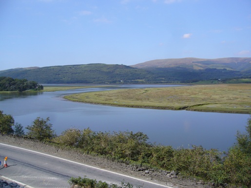
Estuary and mountains combine to create a beautiful setting at Glandyfi, on the Mid-Wales coast. Major civil engineering contractor Carillion is breaking-out the Silurian rocks and stabilising the slope, to realign the A487 trunk road on behalf of the Welsh Government
Picture above: Dyfi Estuary showing part of existing A487.
The A487 is an important N-S route in Wales, which narrows at Glandyfi, a hamlet on the southern flank of the Dyfi estuary. In the shadow of Snowdonia and eight kilometres SW of Machynlleth, Wales’s ancient capital, nightmare tailbacks can occur there as lorries and buses try to pass one another. The 1.3km section of narrow road is perched above the Cambrian Railway. A steep slope rises to the east, and several residential properties pin the narrow snaking road in its current location. Locals were rewarded for their years of patience when the Welsh Government employed consultants Parsons Brinkerhoff to design an improvement.
Gifford (part of global engineering and environmental consultancy Ramboll) is carrying the design forward, as technical advisers to the Welsh Government. Two retained cuttings were included as Contractor-Designed (Design and Build) elements in the Engineering Construction Contract, managed by consultants EC Harris. The £10m contract was awarded to Carillion in March 2011. Tony Gee was employed by Carillion to design the retained cuttings. Construction started in earnest in April 2011.
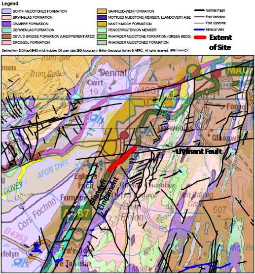
Above: Plan of site with BGS overlay. Derived from DIGMapGB-50 which includes OS open data 250k topography, British Geological Survey Copyright (c) NERC. All rights reserved IPR/144-44CY
EXISTING SLOPES
The slopes that currently confine the road alignment need cutting to allow for widening and straightening work. These slopes typically comprise colluvium above weathered bedrock, with fresh, intact bedrock beneath. Gradients are typically 1 in 5 (but steeper where bedrock is exposed). The colluvium is a granular-cohesive material, the strength and stability of which derive from cohesion of the clay matrix, and a degree of interlock from the included gravels and cobbles. The source material is weathered bedrock, comprising sandstone, siltstone and mudstone beds of the Silurian Devil’s Bridge Formation (DBF) and Borth Mudstones Formation (BMF. The exploitation of structural weaknesses by water and gravity has led to zones of relatively deep weathering, producing clayey gravel with cobbles and occasional boulders.
Late Caledonian (Acadian) folding has created a series of synformal and antiformal axes that trend obliquely to the slope. Through most of the scheme these lead to unfavourable bedding and cleavage orientations that could facilitate wedge and plane failure upon excavation of the new road alignment - an unacceptable risk to the highway as well as a maintenance liability. Two sections therefore require stabilisation: retained cutting RC1 is 15m high and 500m long, and was under construction at time of writing. Retained cutting RC2 is 12m high and 250m long, and was due to commence later in 2011.
The window on the geology exposed to view constantly changes as excavation and construction progress. A recent geological snapshot was observed by Geologists Rhian Kendall from the British Geological Survey, Dr Bob Mathews (Countryside Council for Wales) and Professor Bill Fitches (Central Wales RIGS group) who visited the site during construction of RC1. BGS mapping indicates that the bedrock consists of DBF, a multilayered turbidite sequence. The mudstone-dominated section at the southern end of RC1 closely resembles the partly coeval BMF, which interdigitates with DBF elsewhere in the area; whereas sandstone turbidites become more common in the northern part of RC1.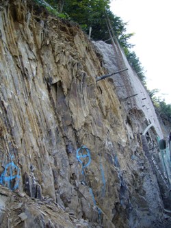
Left: Rock structure exposed, wall construction in background
The primary discontinuity set is the cleavage, which is very well developed, slaty and strongly oblique to bedding (bedding is also strong in sandy layers). Cleavage strikes parallel to the fold axes, and is typically unfavourable for the cutting slope, combining with sub-vertical joints and minor faults, could enable slabs and wedges to slide out. Stereographic analysis was carried out (by Parsons Brinckerhoff) during preliminary design, to inform slope stabilisation requirements.
Burrows and erosional features such as flute casts are preserved, and lustrous purple manganese oxides coat many bedding surfaces. A fault system is apparent within the sandstone-rich section; in the deformed fault zone the beds rapidly steepen and change in orientation. A 0.6m thick quartz vein, which may be part of an en echelon array, is prominent within the deformation zone. The quartz is strong and hard, as evidenced by damage to the teeth of the rock-wheel during excavation.
Other than a little sphalerite within the quartz vein, we encountered no lead, copper or zinc mineralisation - characteristic of the Central Wales Orefield. The deformation zone is probably associated with the Glandyfi Lineament, a composite structure that here marks a divide in the vergence of Acadian folds and cleavage.
RC2 was not yet excavated at time of writing, but we look forward to the exposures it will provide, particularly as the regionally significant Llyfnant Fault (a transverse normal fault of possible Variscan age) passes through the site. We will again be on the lookout for mineralisation, but sadly our experts have assured us that no gold can be expected here.
RETAINED CUTTINGS
The Contractor-Designed retained cuttings are complex geotechnical structures and subject to Geotechnical Category III checks and approval by the Technical Approval Authority (TAA). The Cat. III checks are being performed by consultant WhiteYoungGreen, and the TAA role is being performed by the Welsh Government. The geotechnical certification procedure is in accordance with HD 22/08 Managing Geotechnical Risk.
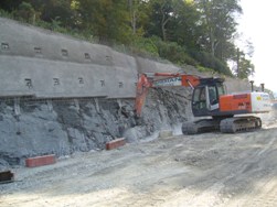
RIght: Rock wheel at work
Complying with the contract requirements set out in the Welsh Government’s Works Information, and with relevant standards, Tony Gee has designed a masonry-faced reinforced concrete wall. In order to prevent slope failure, the design includes a grid of double-corrosion protected and re-stressible rock anchors, using 36mm and 40mm Dywidag bars. Grout encapsulation within plastic sleeves ensures a 120-year design life. The anchors are spaced at intervals of two metres horizontally and three metres vertically, in up to four horizontal rows. The system has built-in redundancy, so if one anchor fails, the load is safely distributed to the surrounding anchors.
Gee’s analysis showed that the maximum stress occurred in the top row; the RC1 top row anchors are 11m long, with 5m bonded length. The bond length was designed to be grouted into moderately strong rock (12MPa Unconfined Compressive Strength), to give design anchor loads of up to 650kPa. Suitability tests were conducted on three trial anchors during the design stage. All installed anchors will be acceptance tested to 135% design load, and locked-off at 110%. The anchors are being drilled, installed and tested by specialist subcontractor CAN Geotechnical.
The anchored face slopes at 12° to the vertical. The slopes are covered by a mesh and sprayed-concrete wall, against which the anchors are stressed. Back-of-wall drains are installed before fixing the mesh.
Carillion elected to excavate the rock in benches using toothed buckets, peckers and rock wheels, rather than blast. GPS guidance is fitted to the excavator for the final trim, to achieve millimetre-perfect precision, where fracture geometry allows. A cleaner finish is achieved on the lower benches, as the fresher rock encountered at depth is less prone to overbreak.
Working area is extremely limited where steep rock slopes rise from the existing road, with large slabs (that look ready to slide if disturbed!). Dowels and rock-catch fences are being employed to stabilise these and protect workers and public.
REWARDING
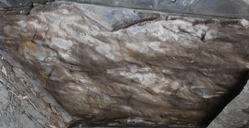
Left: Flute casts and burrows on base of cross-laminated turbidite sandstone. Photo courtesy, Bill Fitches
As a civil engineering project with significant geotechnical content in a challenging geological setting, Glandyfi is an interesting and rewarding project. Proven slope stabilisation techniques, clever programming, a strong emphasis on safety, and collaborative working within the project team are being successfully utilised to deliver a well-needed and long-awaited road improvement. I hope that this article has at least scratched the surface of the wealth of geological interest which a project such as Glandyfi can provide. This interest will continue as further exposures are created, and the engineering challenges which they provide are overcome.
Simplified Sequence of Operations to Construct Retained Cutting
- Conduct Suitability Tests and finalise anchor design
- Excavate bench for top row of anchors
- Drill top row of anchor holes, install and grout anchors
- Install back-of-wall drains, fix mesh and apply sprayed concrete
- Conduct acceptance tests and lock-off anchors
- Excavate next bench for second row of anchors... then back to step 3, and so on
- When all four rows of anchors are installed and spray concreting complete, erect masonry facing using locally sourced stone, and install crest drainage system to drain upper colluvial slopes.
* Iain Bews, BSc CGeol FGS is working for Gifford, part of Ramboll as Client’s Geotechnical Supervisor on the A487 Glandyfi Improvement.
Acknowledgements
Julian Wilson, Contracts Manager, Carillion, for initiating and reviewing this article. Austin Weltman, Chris Young and Tim Ngai of Tony Gee, who designed the retained cuttings. Tudor Roberts of the Welsh Government, for review. Rhian Kendall, BGS, for geological expertise. Dr Bob Mathews, CCW, for geological expertise and review. Professor Bill Fitches, Central Wales RIGS and Geoscience Wales Ltd, for geological expertise and review.